


Servicios Personalizados
Revista

Articulo
 Inglés (pdf)
 Artículo en XML
 Referencias del artículo
 Enviar artículo por email
Indicadores
 Citado por SciELO
 Links relacionados
-
 Similares en
SciELO
Similares en
SciELO
Compartir

 Permalink
Geofísica internacional
versión On-line ISSN 2954-436Xversión impresa ISSN 0016-7169
Geofís. Intl vol.48 no.1 Ciudad de México ene./mar. 2009
Article
Volcanic hazards and risk perception at the "Zoque" community of Chapultenango: El Chichón volcano, Chiapas, México
C. Limón–Hernández1 and J. L. Macías1*
1 Departamento de Vulcanología, Instituto de Geofísica Universidad Nacional Autónoma de México Coyoacán 04510, México City, México * Corresponding author: macias@geofísica.unam.mx
Received: November 9, 2007
Accepted: July 9, 2008
Resumen
Después de 22 años de la erupción de 1982 del Volcán Chichón, se realizó el primer estudio estadístico de los residentes de Chapultenango (10 km al este del volcán), para evaluar la percepción del peligro y riesgo volcánico. Se aplicaron dos métodos: entrevistas con 90 adultos que sobrevivieron la erupción y cuestionarios complementarios a 210 estudiantes que nacieron después de la erupción.
Durante las entrevistas los adultos reconocieron los fenómenos naturales de la erupción de 1982, aunque sólo el 50% estaba lo suficientemente informado sobre los peligros volcánicos, de hecho, sólo el 12% de los entrevistados cree que el volcán podría hacer erupción otra vez. Los cuestionarios muestran que los estudiantes están mejor educados e informados ya que la mayoría cree que el volcán podría hacer erupción nuevamente y están consientes de los peligros que representa. En caso de una nueva erupción, los estudiantes abandonarían sus casas para poner a salvo su vida; de éstos, el 66% conoce las rutas de evacuación.
Los resultados demostraron que los habitantes de Chapultenango, en particular los adultos, tienen una inadecuada percepción del peligro y riesgo volcánico. Encontramos que, no se han implementado programas gubernamentales de largo alcance para incrementar la concientización de la población sobre los peligros volcánicos ni se han desarrollado estrategias para su mitigación.
Palabras clave: Peligro volcánico, percepción del riesgo, preparación para emergencias, Chichón, Chiapas, México.
Abstract
After 22 years of the 1982 eruption of El Chichón volcano, we conducted a statistically based survey of the residents of the community of Chapultenango (10 km east of the volcano) to assess their perception of volcano hazards and risk. The survey used: interviews with 90 adults who survived the 1982 eruption, and completion of questionnaires by 210 students, who were born after the eruption.
While adult interviewees recognized the volcanic phenomena of the 1982 eruption, many remained poorly informed about volcanic hazards. Surprisingly, only 12% of the interviewees believe that the volcano could erupt again. The students are more educated and better informed, and most of them believe that the volcano could erupt again and are well aware of the hazards posed. In case of future eruption, of the students answered that they would abandon their homes to save their lives; 66% knew the evacuation routes.
The results demonstrate that people of Chapultenango –particularly the older residents– have an inadequate perception of volcanic hazards and risk, despite proximity to an active volcano. Unfortunately, no long–term governmental programs to increase public awareness of volcano hazards and to develop hazards–mitigation strategies have been implemented at Chapultenango or other localities surrounding the volcano.
Key words: Volcanic hazards, risk perception, preparedness, Chichón, Chiapas, México.
Introduction
During the 20th century, Mexico has been affected by several volcanic eruptions of varying magnitude and type. These eruptions include the 1913 Plinian eruption of Colima (Saucedo, 1997; Saucedo et al., 2005), the birth of Parícutin from 1943 to 1952 (Flores, 1945), the 1956 eruption of Bárcena in the Revillagigedo islands (Richards, 1959), the 1982 eruption of El Chichón in Chiapas, southern Mexico (Espíndola et al., 2002), the phreatic eruptions of Tacaná in 1950 and 1986 (Macías, 2007), the submarine eruption of Everman in Socorro Island (Siebe et al., 1995), and the reawakening in December 1994 of Popocatépetl, whose eruption continues to present (Macías and Siebe, 2005). Of all these eruptions, the 1982 eruption of El Chichón volcano set an important landmark in volcanological studies in Mexico. The volcano reawakened after 550 years of repose with a violent explosion that killed more than 2,000 people, representing the worst volcanic disaster in Mexico (Tilling, 1989; Espíndola et al., 2000; Macías et al., 2003) and killing more people by pyroclastic surges and flows than any eruption since the 1951 eruption of Mount Lamington, New Guinea which killed some 2,492 people (Taylor, 1958).
The eruption of El Chichón had tremendous local, regional and global impacts. Locally, nine villages, several hamlets, and 100 km2 of forest were destroyed and the region's hydrological network was abruptly modified (Sigurdsson et al,. 1984; Macías et al., 2004). Regionally, the eruption produced darkness during day time at the City of Villahermosa, located about 60 km NE of the volcano in the neighbor state of Tabasco, and ash fall in the Yucatan Peninsula (Varekamp, et al., 1984). Globally, the eruption emitted 7 megatons of sulfur dioxide gas into the atmosphere (Krueger, 1983; Matson, 1984), which produced aerosols that circumnavigated the Earth, causing measurable changes in the temperature of the Earth's surface. Collectively, these effects attracted the attention of volcanologists who studied the chemistry of the rocks (Luhr et al., 1984; Rose et al., 1984; McGee et al., 1987), the new formed crater lake (Casadevall et al., 1984), the pyroclastic deposits (Sigurdsson et al., 1984; 1987), and the presence of anhydrite in the magmas (Luhr et al., 1984; Carroll and Rutherford, 1987; Luhr, 1990). These works dealt primarily with physical aspects of the eruption, but a few social aspects of the eruption were also studied, including migration of the population, recovery or resettlement of towns, damage to crops and forest, and effects of the acid rain (Cervantes–Borja et al., 1983; Báez–Jorge et al., 1985).
During the past decade, several studies concerning risk perception and social aspects of volcanic eruptions have been conducted. Most of these studies were dedicated to understand resilience (Paton et al., 2001; Tobin and Whiteford, 2002), vulnerability (Johnston et al., 2000), preparedness (Gregg et al., 2004), hazards (Robertson, 1994; Chester et al., 2002), risk management (Meztger et al., 1999; Pareschi et al., 2000; Magill and Blond 2005a; 2005b), risk assessment (Pomonis et al., 1999), risk perception (Johnston et al., 1999), and disasters (Witham, 2005). Most of them employed questionnaires and interviews to survey people. Until recently these types of studies had been neglected in Mexico, but during the past decade such studies have been undertaken at: Colima volcano (Cuevas and Ceballos, 2001; Gavilanes et al., 2008); Popocatépetl volcano (Hernández, 2004; López–Vázquez, 2009); and El Chichón (Limón–Hernández, 2005).
In this paper, we present a social–science study of the "Zoque" community of Chapultenango, which is located about 10 km east of the volcano's summit. Using survey interviews with witnesses of the eruption and survey questionnaires with students who were not born until after the eruption but who now live within the volcano's reach, we assess the knowledge and awareness of the Chapul tenango villagers regarding volcanic hazards, risk perception (from a geographic point of view; Slovic, 1987), and preparedness to confront a future eruption of El Chichón. Results of the study are presented and discussed in terms of two sample groups according to age ("adults" and "students"). Finally, we compared these results with studies in other volcanoes in Mexico and elsewhere.
Geologic Background
El Chichón volcano (N17°21'30", W93°13'48"; 1,100 m above sea level) is located in the northwestern area of the Chiapas State in southern Mexico. El Chichón represents the northwestern–most active volcano of the Chiapanecan Volcanic Arc (CVA) (Damon and Montesinos, 1978), formed by the subduction of the Cocos plate beneath the North American plate, at the Middle American Trench (Stoiber and Carr, 1973) (Fig. 1). El Chichón volcano is built upon a late Jurassic–early Cretaceous marine sequence and Tertiary sedimentary rocks (Canul and Rocha, 1981; Duffield et al., 1984). On top of these sedimentary rocks were extruded a 1.1 Ma trachybasalt, whose outcrops are located in the vicinity of Chapul tenango (García–Palomo et al., 2004). The initial phases of volcanism at El Chichón began around 0.37 Ma ago (Layer et al., this issue), followed by the formation of the Somma crater some 0.21–0.27 Ma (Damon and Montesinos, 1978; Duffield et al., 1984) and the extrusion of peripheral domes 0.22 and 0.09 Ma and Holocene activity (Layer et al., this issue).
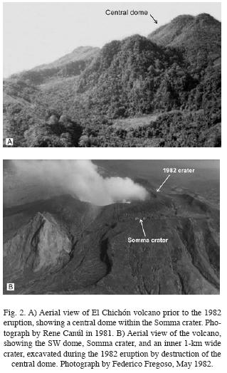
Prior to the 1982 eruption, the volcano consisted of a 2 km–wide Somma crater containing a 1,230 m–high central dome (Fig. 2A). The 1982 eruption destroyed the central dome and formed a 1 km–wide crater inside the Somma crater (Espíndola et al., 2000) (Fig. 2B); this crater holds a lake with active fumaroles, hot mud and small ponds of water (Casadevall et al., 1984; Taran et al., 1998; Tassi et al., 2003; Capaccioni et al., 2004; Rouwet et al, 2004). The pyroclastic surges and flows produced by the 1982 eruption stripped the vegetation cover from the volcano, revealing older pyroclastic deposits which were subsequently studied in the years following the eruption (Tilling et al., 1984; Macías, 1994; Espíndola et al., 2000; Macías et al., 2003). During the past 8,000 years, the volcano has erupted at least 11 times with eruptions occurring at 550, 900, 1250, 1500, 1600, 1900, 2000, 2500, 3100, 3700 and 7700 yr BP. These eruptions have been separated by dormant intervals varying form 100 to 600 years (Espíndola et al., 2000).
Summary of the 1982 eruption
Despite increased fumarolic activity of El Chichón in 1930 (Mullerried, 1933), and the volcano's violent Holocene record (Espíndola et al., 2000), inhabitants of the region in the months preceding the 1982 eruption were not really aware that El Chichón represented an active volcano, let alone a threat to their communities. However, an oral legend says that Piowacwe an old lady, visited the villages around the volcano weeks and days prior to the event announcing the eruption.
Canul and Rocha (1981) reported that residents heard explosions and felt earthquakes at El Chichón since late 1980, and more intensively during 1981. These occurrences were reported by local inhabitants to the local and state authorities in January 1982 (Báez–Jorge et al., 1985), many weeks before the climatic phases of the catastrophic eruptions in late March and early April, 1982. The frequency of noises produced by the explosions and earthquakes both increased during March and were recorded by seismographs located at the Chicoasen hydroelectrical power plant, under construction by the Comisión Federal de Electricidad. The seismographs indicated that on March 6, 30 earthquakes occurred during a 24 hour period. On March 27, 1982, the seismic activity peaked with 66 earthquakes over a four hour period. The first explosion of the 1982 eruption occurred on March 28 at 20:38 hr local time and ended at 23:22 hours (Espíndola et al., 2002). This eruption partially destroyed the central dome and produced an eruptive column that reached 27 km in height in 40 minutes. The volcanic cloud was subsequently transported by stratospheric winds to the NE. The dispersed ash fall covered 30,000 km2 of land, including several towns among which the most important were Francisco León, Volcán Chichonal, Esquipula Guayabal, Nicapa, Ixtacomitán, Chapultenango, Tectuapán, Ostuacán, and Pichucalco (Báez–Jorge et al., 1985). That same day distal ash fall also affected the states of Chiapas, Tabasco, Campeche and some areas of Oaxaca, Veracruz and Puebla (Espíndola et al., 2002).
This eruption surprised the scientific community, the local and federal authorities and the local population, despite the fact that they were all aware of the precursors to the eruption. At that time, Mexico neither had a Scientific Committee to evaluate the eruption nor a Civil Protection Program. Therefore, during the first hours after the eruption an atmosphere of chaos and disorientation prevailed among these groups. Early in the human response to the eruption, most people tried to escape by foot to the nearest towns and afterwards to larger towns and cities. People living on the western side of the volcano escaped towards Ostuacán and those living on the eastern side toward Chapultenango, Ixtacomitán, Tectuapán and Pichucalco. However, ash fall reached these towns and the displaced people moved by increments further northward to Villahermosa, Tabasco or southward to Tuxtla Gutierrez in the State of Chiapas. In contrast, many people remained at their homes close to the volcano during that first night of the eruption, despite the inherent dangers of doing so.
The next day (March 29), the Army secured a zone around the volcano and implemented its emergency plan against disasters called —DNIII (Desastres Naturales III; replaced by the current DN–III–E)— to manage the crisis (SEAN, 1983). The Army forced 45,000 people to abandon their homes and land (Macías and Aguirre, 2006). Between March 29 and April 3, activity at the volcano remained low, but increased dramatically the following day. On April 4 at 7:30 pm, the most violent of all of the 1982 explosions of El Chichón occurred, accompanied by an increase in seismic activity. This climactic phase of the eruption involved hydromagmatic explosions, which completely destroyed the central dome. Pyroclastic surges and flows swept outwards from the crater. These pyroclastic flows were followed by the development of a phreatoplinian column that reached 32 km in height and was dispersed to the NE by stratospheric winds (Carey et al., 1986).
Pyroclastic surges and flows reached as far as 10 km from the crater, affecting an approximated area of 100 km2, where everything was completely flattened and barren (Fig. 3A–B). Beyond this zone, another zone covering some 150 km2 was affected by falling ash, which caused roofs of buildings to collapse (Figs. 3C, and 4A–B). Collectively, these two zones included 35,433 hectares and 29,321 of them were severely damaged. Within the area affected by the eruption lived ca.approximately 6,000 people (INEGI, 1997), of whom about 2,000 were killed by the eruption. Water supplies in both zones were polluted and most animals perished (Báez–Jorge et al., 1985). The villages that were completely or partially destroyed within the two zones were: Volcán Chichonal, Esquipula Guayabal, San Pedro Yaspac, Guadalupe Victoria, Carmen Tonapac, and Vicente Guerrero in Chapultenango county; El Naranjo, Volcán, Francisco León, Trinidad, San Antonio, San Isidro Tanchichal, Agua Tibia and San Juan Bosco in Francisco León county (Figs. 3 and 4).

Most people living in the devastation zone were farmers and had agricultural lifestyles. They grew crops of corn, beans, cacao, and chile, and raised cattle on fertile pastures (Espíndola et al., 2002). Towns such as Chapultenango, Naranjo, Ostuacán, and Nicapa experienced the damaging effects of ash fall; the roofs of the town church and many homes collapsed (Fig. 4). Damage to roofs because of the weight of accumulated ash also occurred widely in the villages of Ixtacomitán, Tectuapán, and Pichucalco, which are located further away from the volcano than Chapultenango. Tephra fall occurred quickly, blocking main roads and paths and isolating many people who were unable to flee the volcano.
Pyroclastic flow deposits blocked the drainage of the Ostuacán–Magdalena River to the southwest of the volcano. These deposits formed a 25 to 75 m–thick natural dam that immediately afterward began to develop a temporary lake (SEAN, 1982; Riva Palacio–Chiang, 1983; Macías et al., 2004). In May 26, water of the lake began to spill over the top of the dam, causing its failure and the generation of two hot, debris flows, that diluted and merged downstream to become a single hyperconcentrated flow (Macías et al., 2004). This flow had a temperature of 90°C at Xochimilco, 82°C at Ostuacán, and 50°C by the time it reached the Peñitas Hidroelectric Dam 25 km downstream. At Pefiitas, the flow generated a large wave that killed one worker and seriously injured four others.
Location of the study area
Chapultenango is situated at a moderate elevation of 640 m above sea level (a. s. l.). It is bordered by the neighboring counties of Pichucalco and Ixtacomitán to the north; Solosuchiapa and Ixhuatán to the east; Tapilula, Pantepec, Tapalpa and Ocotepec to the south; and Francisco León to the west (SEGOB, 1989). Chapultenango county has 6,850 inhabitants (49.6% males, 50.4% females), dedicated to rural activities (INEGI, 2000). About 71% of the county's population is younger than 30 years, with a mean age of 16 years. Our study was conducted in the town of Chapultenango that has a population of 2,794 (48.92% males, 51.08 % females).
Methodology
This study began with semi–structured questionnaires completed by students who did not experience the 1982 eruption and the conduct of interviews with the adults who did. The adult group ranged in age from 26 to 95 years (average 55); the student group ranged in age from 10 to 22 years (average 14). The questionnaire was administered at the students' schools with the support of teachers and county authorities. To test the efficiency of the questionnaire, we carried out a pilot study involving only 1% of the population. Following the pilot study, the questionnaire was slightly modified before it was administered for the entire sample group. Both the questionnaires and the interviews consisted of two parts—one containing demographic questions, and the other containing questions specific to the volcano.
To obtain statistically valid results, we calculated the minimum sample to be surveyed using the equation (Duffau, 1999):

where:
• N = Total population (2,794)
• Za2 = 2.242 (with a confidence value of 97.5%)
• p = expected proportion (in this case 2.5% = 0.025)
• q = 1 – p (in this case 1–0.025 = 0.975)
• d = precision (we want 2%)
Thus, for a study with 97.5% confidence and 2% precision a minimum sample, n = 275, was calculated:
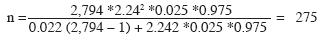
We exceeded this minimum sample by studying 300 people, 90 of whom were interviewed (see Appendix A for interview questions), and the remainder (210) answered questionnaires (see Appendix B). The percentage of participants completing questionnaires (70%) correlates with the percentage of young people (71%) out of the total population of Chapultenango. Then, the information obtained was processed in a spread sheet and graphically (Figs. 5–10).
Results
Questionnaire Survey of Students
All the student respondents were not yet born at the time of the 1982 eruption. The ages of the students range between 10 and 22 years old (14 average), of which 87% are Catholics, 9% are Adventist, and a minority (4%) not practicing any religion. Overall, 38% are bilingual; they speak the local Zoque language as well as Spanish. Some 28% have never visited the summit area of El Chichón volcano, with the lowest percentages among elementary school students. About 30% were aware of the 1982 eruption and its impacts in their surroundings. Among the 70% that did not, 12% knew some other details on the origin of the volcanic activity, 18% mentioned other types of information related to the volcano and its history such as legends, 22% described other subjects not relevant to the eruption, and 18% indicated that they do not know anything related to El Chichón volcano. Not surprisingly, comparing the results among the different education levels it is clear that high school students (44%) know more information about the eruption than do elementary and secondory school students.
Of the student respondents, 54% fear living close to the volcano, although elementary school students were the most fearful (67% said they feared the volcano compared to fewer percent in the other groups). A similar number (56%) stated not having been informed about the activity of the volcano (Fig. 5A), This latter percentage compares well with 65% of the group who believe they know who can help them to be better prepared in case of a future eruption. 39% of the students will turn to the county authorities, as they believe the county authorities are responsible for public safety and are aware of current state of the volcano (Fig. 5B). Surprisingly, 80% of the students sampled believe that the volcano will erupt again, and in such case, 91% will be ready to leave their homes when it occurs (Fig. 6A).
We assessed the levels of the respondents' knowledge of basic preparedness for a volcanic eruption, and 66% of them know the evacuation route, which is the paved road connecting Chapultenango with Ixtacomitán and Pichucalco towns. However, in case of a future eruption, only 40% of the students will bring along personal belongings such as important documents, radio, flash lights, and medicine. 28% of the students do not know which type of belongings they should have with them (Fig. 6B).
Interviews with adults who experienced the 1982 eruption
We carried out 90 interviews with the adults who experienced the 1982 eruption; these respondents ranged in age from 26 to 95 years (average 55), and they were born in Chapultenango or in towns around El Chichón. Overall, 79% of this group is Catholic and 14% Seventh Day Adventist; the balance does not practice any religion. About 48% are bilingual; they speak the local Zoque language as well as Spanish. Not surprisingly, levels of education in this rural area were not high. About half of the interviewees did not have the opportunity to study in a formal educational setting. Only 36% started elementary school, although most of them only attended the first few grades because: the schools were too far from their homes; the family had economic problems; or there was an absence or scarcity of teachers. In fact, only 4% of the interviewees finished formal schooling. Today, most people's livelihoods are dedicated to agriculture (48%), household (21%), small business (15%), and the rest to other economic activities (16%). Today, most houses of Chapultenango are built with concrete walls (75%), bamboo (22%), and wood (3%); and with metal roofs (83%), concrete (15%), and other types of materials (2%).
Of the total sample of those interviewed, 50% were born in Chapultenango, while 44% relocated there from other places after the 1982 eruption. Overall, 87% voluntarily fled the volcano to save their lives, while 13 % were forced to leave by the Army (Fig. 7A). This accords well with their statements about the intervention of authorities during the 1982 eruption, mostly involving the National Army (67%) and county government (15%). The displaced villagers became refugees in shelters located in Chiapas (50%), Tabasco (41%), and other places (9%) (Fig. 7B). Half of the population stayed away from their communities for months (49%), years (29%), or days (15%) following the eruption, while some of them never repopulated their villages (7%) (Fig. 7C). This latter number is related to villages that were completely destroyed by pyroclastic surges and uninhabitable after the 1982 eruption because the lands were no longer productive for agriculture (e.g., Esquipula Guayabal, San Pedro Yaspac, Francisco León, Tanchichal, etc).
One question was asked to help us understand the types of hazardous phenomena that were observed by villagers during the eruption. The interviewees described with their own words phenomena such as ash falls (33%. rain of sand), pyroclastic flows (20%, fire pouring out from the volcano), electric storms (11%, thunder and lightning), explosions (18%), lahars (1%, boiling rivers), 8% felt earthquakes, 6% considered other aspects, and the rest did not witness any phenomena (Fig. 8). The eruption caused severe problems for the interviewees, including the collapse of metal roofs (40%), destruction of crops (28%), loss of cattle and other livestock (24%), and, unfortunately, the death of family members during the eruption (4%) (Fig. 9A). In most cases, the bodies of the people killed were never found by the surviving relatives.
On average, 47% of the interviewees believed that the volcano will erupt again, but not at time soon—in hundreds of years rather than months, years or decades. Some 20% believed that the volcano will not erupt again, and 33% did not have an idea of what might happen (Fig. 9B).
Some interview questions were posed to obtain the people's perception of risk. For instance, 65% of the sample believes that they will be affected by a future eruption (because they live too close to the volcano), while 35% hold the opposite perception (because the volcano will not erupt again). If eruption should occur, 49% of the people said they will stay in Chapultenango, not because they do not fear the volcano, but because during the 1982 eruption their abandoned or evacuated homes and property were looted. The rest (51%) reported that they will immediately leave to save their lives and their families. However, these numbers do not correlate with the measures they will need to take to protect themselves during the time of an impending eruption, because 82% of the people do not know what to do. Some 7% indicated that they will follow instructions of local authorities while 11% indicated that they will take their own measures. Despite the high percentage (82%) reporting that they do not know what to do in an eruption, more than half of the respondents indicated that they have received volcano information from sources such as the local authorities (25%), geologists and volcanologists that periodically visit the volcano (10%), the media (3%), by their own means (13%), and by visiting the volcano themselves (12%) (Fig. 10). However, 37% said that nobody had informed them about the volcano, and a similar number (44%) did not know about emergency plans.
Finally, the interviewees in Chapultenango affirmed that, despite the adverse impacts, the 1982 eruption also brought several benefits to their community, including a paved road, services such as telephone, electricity, etc, as well as natural fertilization of soils by chemical nutrients adhered to the tephra and other socio–economics improvements.
Discussion
Analysis of results at El Chichón volcano
Our study presents the first data obtained from a social–science study of the community of Chapultenango after the 1982 eruption of El Chichón. One of the most interesting aspects of the survey was to evaluate the volcanic hazards and related phenomena witnessed by the adult group that experienced the eruption. During the March 28, 1982 eruption, this group recognized ash fallout and earthquakes as the main hazards. This observation correlates fairly well with the stratigraphy described for this particular eruption, which emplaced a single fallout layer designated "A" by Sigurdsson et al. (1984). However, it is possible that the adult group at Chapultenango did not recognize other phenomena during the March 28 eruption (i.e., lightning, thunder, and explosions) because the town does not have a direct line of sight to the volcano and also because of the complete chaos that ensued during the eruption in all towns around the volcano. In fact, 87% of the adults were trying to escape by foot to the nearby communities of Ixtacomitán and Pichucalco. During the following day (29 March), 13% of the adults were evacuated by the Army, and most of them never returned to their homes. At the time of the April 3 explosion, which occurred at night and was the most violent event of the 1982 eruption (Yokoyama et al., 1992), most adults were at shelters in the town of Pichucalco. Even though this town is situated 20 km NE of El Chichón, it has a better view of the volcano than that from Chapultenango. Thus, people at Pichucalco, including most of the adults interviewed, were able to witness the 3 April explosion.
During the April 3 explosion, the adult group experienced earthquakes, thunder storms, explosions, ash fall, and pyroclastic flows. These hazards were also witnessed and reported by volcanologists of the Geophysics Institute of UNAM who were staying in the town of Ostuacan some days before this cataclysmic eruption (personal communication, Servando De la Cruz–Reyna). Moreover, days to months after the April 3 eruption, the adult group, other witnesses, and scientists observed the occurrence of lahars in several gullies around the volcano (personal communication, F. Fregoso).
As a group, the students are better informed about the volcano and related activity (82%) than are the adults (43%). About 80% of the students thought that the volcano will erupt again because volcanism is a natural phenomenon, and that the longer it takes to renew its activity, the greater the possibility of another eruption. In contrast, 53% of the adults thought that the volcano will not erupt again, perhaps assuming that volcanoes erupt only once during their entire life span. Some 54% of the students are afraid to live close to the volcano, because they believe that, in a future eruption, they will not have enough time to leave their community before being buried by ash. In contrast, 65% of the adults are conscious that their community will be affected by a future eruption, but they are not afraid because they survived the one in 1982. They now believe they will know what to do and how to react in a future eruption. It appears that their beliefs about what they should do are based more on their prior experience with the 1982 eruption or information that they obtained informally since the eruption; a minority of them (25%) indicated they had been informed about preparedness, emergency plans, and evacuation routes. Students, on the other hand, apparently had received more information than the adults (44%). Thus, it is clear that the adults' thinking reflected experience gained during the 1982 eruption, but that does not necessarily mean that their intentions are what would be desired by authorities. For example, while 91% of the students said they would evacuate the town in a future eruption, only 51% of the adults said they would leave. Perhaps the 49% of the adults who stated that they will not leave their homes in the next eruption reflects their worry that during the 1982 eruption they and others suffered at the shelters and their properties were looted while they were away from their homes.
Since 1982, little to no effective educational information or emergency plans have been given to the population of Chapultenango although some information has been presented at schools and people have obtained 'information' or knowledge through past experiences. Johnston et al. (1999) demonstrated that, when a population perceives its vulnerability to any type of natural phenomena, it is more likely that they will respond to warnings of danger and, therefore, respond to preventative measures. Thus, it is important that a comprehensive educational information program be started to increase the awareness of hazards of people among the populations around El Chichón volcano to increase their ability to effectively respond to, or otherwise cope with, the next eruption. During the past 10 years, there have been some attempts by scientists to initiate a volcano– monitoring program in the State of Chiapas, to keep the populations and civil authorities around El Chichón informed of the volcano's activity, its hazards, and emergency response plans (Ramos et al., 2007). Unfortunately, these recent attempts do not represent a concerted policy of the Chiapas State to reduce the threat of volcanic hazards and risk posed by possible renewed eruptions of El Chichón. Underlying causes for the absence of such a policy is the lack of sufficient financial resources and trained personnel to carry out an effective program of volcano monitoring and public education.
Johnston et al. (1 999) reported that people's knowledge of a hazard is directly related to the degree of expected maximum hazard, the degree of damage from prior events, and the degree of information available about the hazard. For Ruapehu Volcano, New Zealand, these authors concluded that the perception of risk is linked to people's proximity to the volcanic center, the likelihood of a future disaster, the impact level, and past disaster experiences (Paton et al., 2001). If so, then Chapultenango and communities around El Chichón represent an excellent opportunity for such inquiry. These studies have increased during the last few years, in communities in Kona on the Island of Hawaii (Gregg et al., 2003), Santorini Greece (Dominey–Howes and Minos–Minopoulos, 2004), Arenal Costa Rica (Acuña and Varela, 2003), and Ruapeu New Zealand (Johnston et al., 2000).
Comparison with studies at other volcanoes
The study of the Chapultenango community at El Chichón volcano showed striking results. Some 43% of the sample surveyed did not even know that El Chichón was a volcano—especially a potentially active volcano— prior to the 1982 eruption. This finding is somewhat surprising given the few pre–1982 geological studies (Mullerried, 1933; Damon and Montesinos, 1978; Canul and Rocha, 1981) that classified it as an "active" volcano. In comparison, at Santorini, Greece, 93% and 60% of people surveyed knew that the islands of Nea Kameni and Monte Columbo represented active volcanoes, respectively (Dominey–Howes and Minos–Minopoulos, 2004); both Nea Kameni and Monte Columbo are island volcanoes and this may explain the people's perceptions.
Table 1 shows the volcanic hazards that the population of Chapultenango perceive as genuine threats to their community. These hazards, in order of importance as perceived by the people, are: tephra fallout and ballistics (33%), pyroclastic flows (20%), earthquakes (8%), electric storms (11%), and explosions (18%). If we compare the volcanic hazard considered the most dangerous (33 %) at El Chichón (tephra fallout and ballistic projectiles) with other studied cases, we note similar results for Colima volcano (34%). However, both these percentages are lower if they are compared to Nea Kameni, Greece (53%) (Dominey–Howes and Minos–Minopoulos, 2004). On the contrary, lava flows and gases are perceived as the most dangerous hazards at Monte Columbo and Santorini volcanoes in Greece, and Colima volcano, in Mexico (Cuevas and Ceballos, 2001). Such hazards do not represent threats to the Chapultenango inhabitants, because El Chichón is not a lava flow producer.
When people were asked if the volcano will erupt again, only 47% believed that El Chichón will erupt in the future. This figure contrasts with the higher percentages obtained at Colima volcano (80%), and Mauna Loa (71 %), Hualalai (66%) in Hawaii. Obviously, these percentages reflect the higher eruption frequencies at Colima (Cuevas and Ceballos, 2001) and Hawaii frequent eruptions (Gregg et al., 2003) during recent centuries or even decades.
People who live around active volcanoes perceive risk in different ways. For example, only 6% of the people surveyed in Hawaii consider that their community will be affected by a future eruption of Mauna Loa and/or Kilauea volcanoes (Gregg et al., 2003), this low percentage may be influenced by the fact that eruptions in recent centuries have been mostly non–explosive (personal comm. Robert I. Tilling). This number increases to 23% at Arenal volcano, Costa Rica (Acuña and Varela, 2003), 65% at El Chichón, and as high as 80% at Colima Volcano (Cuevas and Ceballos, 2001). In case of a future eruption, 49% of those surveyed at El Chichón will stay at their community analyzing the situation prior to evacuate; similar numbers were obtained at Nea Kameni (46%) and Arenal (49%).
In terms of public safety and emergency plans, 40% of the people at Arenal volcano and 44% at El Chichón volcano have not heard about evacuation plans, nor the location of evacuation routes or shelters. This finding also applies to the results obtained at Santorini, for a question as to whom the population thinks may inform them during a volcanic crisis: the county major (44%), the police (23%), the national government (23%), the army (20%), and the mass media (12%). At El Chichón, the answers also range widely, with 25% saying county authorities would alert them, 10% geologists and volcanologists, and 3% the mass media. Some (25%) said by their own means and 37% indicated that they do not know who will inform them. Surprisingly, at Popocatépetl volcano, 64% of those interviewed mentioned that the mass media, reflecting the attention posed by the mass media to the Popocatépetl volcanic crisis because its location nearby large metropolitan areas as Mexico City, Puebla, Tlaxcala, and Cuernavaca—with a combined total population of ca. 30 million people.
The 1982 eruption of El Chichón volcano represents the worst volcanic disaster that has occurred in Mexico in recorded history. Yet, twenty seven years after this catastrophic event, Mexico still has not been able to implement an effective national educational program, capable to operate in a consistent way, for people living around volcanoes. Such a program will be feasible, only if the local authorities in charge of the civil protection programs are not removed every three years by the county head in charge. Therefore, scientists and the local civil authorities need to assess the inadequacies of current policies and practices, to convince the federal government to modify and further improve efforts to reduce risk from volcanic hazards.
Conclusions
The March 28–April 4, 1982 eruption of El Chichón volcano, devastated the surrounding areas; nine towns were destroyed and more than 2,000 people were killed. People who lost property but survived the eruption migrated to other towns near El Chichón, damaged less by the eruption than their towns. One of these towns was Chapultenango. Our interviews with Chapultenango adults (> 26 years old) and questionnaires completed by its students (10–22 years old) evaluated their perception regarding volcanic hazards, risk, and preparedness to cope with a future eruption. The adult group experienced and survived the eruption and was aware of pyroclastic flows, tephra falls, and lahars as the hazards during the 1982 eruption. Nonetheless, they now largely believe that El Chichón will not erupt again in the near future. In contrast to the adults' beliefs, the student group perceives that another eruption may occur since the volcano is active. They seem better prepared to face the possibility of a new eruption than the adult group, because they know more information from the school, family, the community, and the mass media. Should El Chichón erupt again, the Zoque community of Chapultenango still remains highly vulnerable to the hazards of ballistic projectiles and tephra fall because most houses are made of bamboo walls and flimsy metal roofs.
From our study, we conclude that, since the 1982 eruption, little to no effective educational information or emergency plans have been given to the population of Chapultenango. Therefore, we recommend implementing a comprehensive educational information program for the populations living near El Chichón volcano to increase their ability to effectively respond to or otherwise cope with the next eruption. This program should include the county, civil protection and government officials as well as the scientific community involved in volcano monitoring and hazards studies. Finally, by comparing the results of this social science study at El Chichón volcano, with similar studies at volcanoes elsewhere, it appears that, regardless of the level of educational information provided or extent of response plans in Mexico and other countries, the general public's knowledge of volcanic hazards varies markedly.
Acknowledgments
This project was supported by grants from Consejo Nacional de Ciencia y Tecnología (27993–7 to J.L. Macías), CNR–CONACYT Bilateral Project to J.L. Macías and Dirección General de Asuntos del Personal Académico, Universidad Nacional Autónoma de México (IX101404 to J.L. Macías). We are indebted to Chris Gregg who provided a careful review of an earlier version of the manuscript and helped to clarify ideas. We thank the technical support of A. M. Rocha. We appreciate the thoughtful reviews of the manuscript by R. I. Tilling and an anonymous reviewer.
Bibliography
Acuña, O. and A. Varela, 2003. Análisis de la percepción de riesgo en la Fortuna de San Carlos y alrededores. Universidad de Costa Rica. [ Links ]
Báez–Jorge. F., A. Rivera–Balderas and P. Arrieta–Fernández, 1985. Cuando el cielo ardió y se quemó la tierra. Condiciones socioeconómicas y sanitarias de los pueblos Zoques afectados por la erupción del volcán Chichonal: México. Instituto Nacional Indigenista, Colección INI, Serie de Investigaciones Sociales, 309 p. [ Links ]
Canul, R. F. and V. L. Rocha, 1981. Informe geológico de la zona geotérmica de "El Chichonal," Chiapas: Comisión Federal de Electricidad, Informe (Unpublished internal report). [ Links ]
Capaccioni, B., Y. Tarán, F. Tassi, O. Vaselli, F. Mangani and J. L. Macías, 2004. Source conditions and degradation processes of light hydrocarbons in volcanic gases: an example from El Chichón volcano, Chiapas State of Mexico. Chemical Geology 206, 81–96. [ Links ]
Carey, S. N. and H. Sigurdsson, 1986. The eruptions of El Chichón volcano–Mexico (2): observations and numerical modelling of tephra fall distribution. Bull. Volcanol. 48, 127–141. [ Links ]
Carroll, M. R. and M. J. Rutherford, 1987. The stability of igneous anhydrite. Experimental results and implications for sulfur behaviour in the 1982 El Chichon trachyandesite and other evolved magmas. J. Petrol. 28, 781–801. [ Links ]
Casadevall, T. J., S. De la Cruz–Reyna, W. I. Rose, S. Bagley, D. L. Finnegan and W. H. Zoller, 1984. Crater Lake and Post–Eruption Hydrothermal Activity, El Chichón Volcano, México. J. Volcanol. Geotherm. Res. 23, 169–191. [ Links ]
Cervantes–Borja, J., F. Orozco–Chávez, M. Meza–Sánchez and J. Tricart, 1983. Determinación preeliminar de los daños causados al medio natural por las erupciones del volcán Chichonal, en 1983. El Volcán Chichonal: Ponencias presentadas en el simposio sobre el volcán Chichonal durante la VI Convención Geológica Nacional de la Sociedad Mexicana. UNAM, México. 100–120. [ Links ]
Chester, D. K., C. J. Dibben and A. M. Duncan, 2002. Volcanic hazard assessment in western Europe. J. Volcanol. Geotherm. Res. 115, 411–435. [ Links ]
Cuevas A. and E. Ceballos, 2001. Información a las comunidades. La clave en la mitigación del riesgo volcánico. In: Macías, J. M., eds., Reubicación de comunidades humanas. Entre la producción y la reducción de desastres. Universidad de Colima, México, 237–250. [ Links ]
Damon, P. and E. Montesinos, 1978. Late Cenozoic volcanism and metallogenesis over an active Benioff Zone in Chiapas, Mexico. Arizona Geological Society Digest 11, 155–168. [ Links ]
Dominey–Howes D. and D. Minos–Minopoulos, 2004. Perceptions of hazards and risk on Santorini. J. Volcanol. Geotherm. Res. 137, 285–310. [ Links ]
Duffau, T., Gastón. 1999. Tamaño muestral en estudios biomédicos. Rev. Chil. Pediatra 70, 314–324. ISSN 0370–4106. [ Links ]
Duffield, W. A., R. I. Tilling and R. Canul, 1984. Geology of Chichón Volcano, Chiapas, Mexico. J. Volcanol. Geotherm. Res. 20, 117–132. [ Links ]
Espíndola, J. M., J. L. Macías, R. I. Tilling and M. F. Sheridan, 2000. Volcanic history of El Chichón Volcano (Chiapas, Mexico) during the Holocene, and its impact on human activity. Bull. Volcanol. 62, 90–104. [ Links ]
Espíndola, J. M., J. L. Macías, L. Godínez and Z. Jiménez, 2002. La erupción de 1982 del Volcán Chichonal, Chiapas, México, in Lugo, H. J. and M. Inbar, eds., Desastres Naturales en América Latina: México, D. F., Fondo de Cultura Económica 37–65. [ Links ]
Flores, L. C., 1945. Cálculos para la determinación de la altura del cono del volcán del Parícutin: in El Parícutin: México, D. F., Universidad Nacional Autónoma de México 19–20. [ Links ]
García–Palomo, A., J. L. Macías and J. M. Espíndola, 2004. Strike–slip faults and K–Alkaline volcanism at El Chichón volcano, southeastern Mexico. J. Volcanol. Geotherm. Res. 136, 247–268. [ Links ]
Gavilanes, J. C., A. Cuevas, N. Varley, G. Gwynne, J. Stevenson, R. Saucedo, A. Pérez, M. Aboukhalil and A. Cortés, 2008. The influence of increased activity on the perception of volcanic risk: the case of Volcán de Colima, Mexico. J. Volcanol. Geotherm. Res. (subbmitted). [ Links ]
Gregg, C. E., B. F. Houghton, D. M. Johnston, D. Paton and D. A. Swanson, 2004. The perception of volcanic risk in Kona communities from Mauna Loa and Huala–lai volcanoes, Hawaii. J. Volcanol. Geotherm. Res. 130, 179–196. [ Links ]
Hernández, Y., 2004. Percepción de riesgo volcánico y estrategias de afrontamiento de habitantes de zonas rurales y urbanas entorno al Popocatépetl. (Thesis) Universidad de Las Americas, México, 65 p. [ Links ]
INEGI (Instituto Nacional de Estadística Geografía e Informática), 1997. Anuario Estadístico del Estado de Chiapas. Gobierno del Estado de Chiapas, 494 p. [ Links ]
INEGI (Instituto Nacional de Estadística Geografía e Informática), 2000. XII Censo General de Población y Vivienda, México. Chiapas 400 p. [ Links ]
Johnston, D. M., M. S. Bebbington, C. D. Lai, B. F. Houghton and D. Paton, 1999. Volcanic hazard perceptions: comparative shifts in knowledge and risk. Disaster Prev. Manager 8, 118–126. [ Links ]
Johnston, D. M., B. F. Houghton, V. E. Neal, K. R. Ronan and D. Paton, 2000. Impacts of the 1945 and 1995–1996 Ruapehu eruptions, New Zealand: An example of increasing societal vulnerability. Bull. Geol. Soc. Amer. 112, 720–726. [ Links ]
Krueger, A. J., 1983. Sighting of El Chichon sulfur dioxide clouds with the Nimbus 7 total ozone mapping spectrometer. Science 220, 1377–1379. [ Links ]
Limón–Hernández, C., 2005. Análisis de la percepción del riesgo en los volcanes Chichón y Tacaná, Chiapas. Facultad de Filosofía y Letras, UNAM. Bachelor Thesis. [ Links ]
López–Vázquez, E., 2008. Risk perception, and coping strategies for risk from Popocatépetl Volcano, Mexico, Geof. Int., 48, 133–147. [ Links ]
Luhr, J. F., I. S. E. Carmichael and J. C. Varekamp, 1984. The 1982 eruptions of El Chichón Volcano, Chiapas, Mexico: mineralogy and petrology of the anhydrite–bearing pumices. J. Volcanol. Geotherm. Res. 23, 69–108. [ Links ]
Luhr, J. F., 1990. Experimental phase relations of water–and–sulfur–saturated arc magmas and the 182 eruptions or El Chichon volcano. J. Petrology 31, 1071–1114. [ Links ]
Macías, J. L., 1994. Violent short–lived eruptions from small–size volcanoes: El Chichón, Mexico (1982) and Shtyubel', Russia (1907): (Ph. D. thesis): Buffalo, State University of New York at Buffalo, 193 p. [ Links ]
Macías, J. L., J. M. Espíndola, Y. Taran and P. A. García, 1997a. Explosive volcanic activity during the last 3,500 years at El Chichón Volcano, Mexico. IAVCEI, General Assembly, Puerto Vallarta, Mexico. Field Trip Guide, 53 p. [ Links ]
Macías, J. L., M. I. Bursik, J. M. Espíndola and M. F. Sheridan, 1998. Development of coarse–lithic–concentration zones in the 1982 block–and–ash flow deposits at El Chichon Volcano, Mexico. J. Volcanol. Geotherm. Res. 83, 173–196. [ Links ]
Macías, J. L., J. L. Arce, J. C. Mora, J. M. Espíndola, R. Saucedo and P. Manetti, 2003. The ~550 BP Plinian eruption of el Chichon volcano, Chiapas, Mexico: Explosive volcanism linked to reheating of a magma chamber. J. Geophys. Res. 108(B12) 2569. [ Links ]
Macías, J. L., L. Capra, K. M. Scott, J. M. Espíndola, A. García–Palomo and J. E. Costa, 2004. The May 26, 1982, breakout flow derived from failure of a volcanic dam at El Chichón Volcano, Chiapas, Mexico. Bull. Geol. Soc. Amer. 116, 233–246. [ Links ]
Macías, J. L. and C. Siebe, 2005. Popocatépetl's crater filled to the brim: Significance for hazard evaluation. J. Volcanol. Geotherm. Res. 141, 327–330. [ Links ]
Macías, J. M. and B. Aguirre, 2006. A critical evaluation of the united nations volcanic emergency management system: Evidence from Latin America. Journal of International Affairs 59, 43–61. [ Links ]
Macías, J. L., 2007. Geology and eruptive history of some active volcanoes of México, in Alaniz–Álvarez, S. A. and Á. F. Nieto–Samaniego, eds., Geology of México: Celebrating the Centenary of the Geological Society of México. Geological Society of America Special Paper 422, 183–232. [ Links ]
Magill, C. and R. Blong, 2005a. Volcanic risk ranking for Auckland, New Zealand. I: Methodology and hazard investigation. Bull. Volcanol. 67, 331–339. [ Links ]
Magill, C. and R. Blong, 2005b. Volcanic risk ranking for Auckland, New Zealand. II: Hazard consequences and risk calculation. Bull. Volcanol. 67, 340–349. [ Links ]
Matson, M., 1984. The 1982 El Chichon volcanic eruptions – A satellite perspective. J. Volcanol Geotherm. Res. 23, 1–10. [ Links ]
McGee, J. J., R. I. Tilling and W. A. Duffield, 1987. Petrologic characteristics of the 1982 and pre–1982 eruptive products of El Chichón volcano, Chiapas, Mexico. Geof. Int. 26, 85–10. [ Links ]
Metzger, P., R. D'Ercole and A. Sierra, 1999. Political and scientific uncertainties in volcanic risk management: The yellow alert in Quito in October 1998. GeoJournal 49, 213–221. [ Links ]
Müllerried, F. K. G., 1933. El Chichón, único volcán en actividad descubierto en el estado de Chiapas: Memorias de la Sociedad Científica. "Antonio Álzate" 54, 411–416. [ Links ]
Pareschi, M. T., L. Cavarra, M. Favalli, F. Grannini and A. Meriggi, 2000. GIS and volcanic risk management. Natural Hazards 21, 361–379. [ Links ]
Paton, D., M. Millar and D. Johnston, 2001. Community Resilience to Volcanic Hazard Consequences. Natural Hazards 24, 1–3. [ Links ]
Pomonis, A., R. Spence and P. Baxter, 1999. Risk assessment of residential buildings for an eruption of Furnas Volcano, Saõ Miguel, the Azores. J. Volcanol. Geotherm. Res. 92, 107–131. [ Links ]
Ramos, S., H. Schoeder, R. Quaas, E. Guevara, M. Armienta, G. Castelán, C. Morquecho, P. Alonso and S. De la Cruz–Reyna, 2007. Government actions in the monitoring of the "El Chichón Volcano", in Espíndola, J. M., J. L. Arce and J. L. Macías, eds., El Chichón Volcano: Twenty–five years later. A Commemorative Conference. UNAM, San Cristobal de las Casas, Chiapas, México, p. 92. [ Links ]
Richards, A. F., 1959. Geology of the Islas Revillagigedo, Mexico. 1. Birth and development of Volcan Barcena, Isla San Benedicto. Bull. Volcanol. 22, 73–124. [ Links ]
Riva Palacio–Chiang, R., 1983. Informe y comentarios acerca del Volcán Chichonal, Chiapas. El Volcán Chichónal. Revista del Instituto de Geología, UNAM, México, 49–56. [ Links ]
Robertson, R. E., 1994. Volcano monitoring and hazard assessment in the Eastern Caribbean. Disaster Management 6, 206–212. [ Links ]
Rose, W. I., T. J. Bornhorst, S. P. Halsor, W. A. Capaul, S. Lumley, S. De la Cruz–Reyna, M. Mena and R. Mota, 1984. Volcan El Chichón, Mexico: Pre–1982 S–rich eruptive activity. J. Volcanol. Geotherm. Res. 23, 147–167. [ Links ]
Rouwet, D., Y. Taran and N. Varley, 2004. Dynamics and mass balance of El Chichón crater lake, Mexico. Geof. Int. 43, 427–434. [ Links ]
Saucedo, G. R., 1997. Reconstrucción de la erupción de 1913 del Volcán de Colima. (Master Thesis): México D. F., Universidad Nacional Autónoma de México, 185 p. [ Links ]
Saucedo, R., J. L. Macías, M. F. Sheridan, M. I. Bursik and J. C. Komorowski, 2005. Modeling of pyroclastic flows of Colima Volcano, Mexico: implications for hazard assessment. J. Volcanol. Geotherm. Res. 139, 103–115. [ Links ]
SEAN (Scientific Event Alert Network), 1982. Volcanic events: El Chichón volcano, Smithsonian Institution. Bull. Volcanol. 7(5), 2–6. [ Links ]
SDN (Secretaría de la Defensa Nacional), 1983, El Plan DN–III–E y su aplicación en el área del Volcán Chichonal, in VI Contención Geológica Nacional de la Sociedad Geológica Mexicana: Mexico, D. F., Universidad Nacional Autónoma de México, Instituto de Geología, 90–100. [ Links ]
SEGOB (Secretaria de Gobernación), 1989. Enciclopedia de los municipios de México. Tomo IV (Chiapas), Centro Nacional de Estudios Municipales, 1987–1988, México, D. F. [ Links ]
Siebe, C. G., J. C. Komorowski, C. Navarro, J. McHone, H. Delgado and A. Cortés, 1995. Submarine eruption near Socorro Island, Mexico: Geochemistry and scanning electron microscopy studies of floating scoria and reticulate. J. Volcanol. Geotherm. Res. 68, 239–272. [ Links ]
Sigurdsson, H., S. Carey and J. Espíndola, 1984. The 1982 eruption of El Chichón volcano, Mexico: Stratigraphy of pyroclastic deposits. J. Volcanol. Geotherm. Res. 49, 467–488. [ Links ]
Sigurdsson, H., S. N. Carey and R. V. Fisher, 1987. The 1982 eruptions of El Chichón volcano, Mexico (3): Physical properties of pyroclastic surges. Bull Volcanol, 49, 467–488. [ Links ]
Slovic, P., 1987. Perception of Risk. Science 236, 280–285. [ Links ]
Stoiber, E. R. and M. J. Carr, 1973. Quaternary volcanic and tectonic segmentation of Central America. Bull. Volcanol. 37, 1–22. [ Links ]
Taran, Y., T. P. Fischer, B. Pokrovsky, Y. Sano, M. A. Armienta and J. L. Macías, 1998. Geochemistry of the volcano–hydrothermal system of El Chichón Volcano, Chiapas, México. Bull. Volcanol. 59, 436–449. [ Links ]
Tassi, F., O. Vaselli, B. Capaccioni, J. L. Macías, A. Nencetti, G. Montegrossi, G. Magro and A. Buccianti, 2003. Chemical composition of fumarolic gases and spring discharges from El Chichón volcano, Mexico: causes and implications of the changes detected over the period 1998–2000. J. Volcanol. Geotherm. Res. 13(1–2), 105–121. [ Links ]
Taylor, G . A., 1958. The 1951 eruption of Mount Laming–ton, Papua. Aust. Bur. Min. Resour. Geol. Geophys. Bull., 38, 1–117. [ Links ]
Tobin, G. A. and L. M. Whiteford, 2002. Community resilience an volcano hazard: The eruption of Tungurahua and evacuation of the Faldas in Ecuador Disasters. The Journal of Disaster Studies. Policy and Management 26, 28–48. [ Links ]
Tilling, R. I., M. Rubin, H. Sigurdsson, S. Carey, W. A. Duffield and W. I. Rose, 1984. Holocene eruptive activity of El Chichón volcano, Chiapas, México. Science, 224, 747–749. [ Links ]
Tilling, R. I., 1989. Volcanic hazards and their mitigation: progress and problems. Rev. Geophys. 27, 237–269. [ Links ]
Varekamp, J. C., J. F. Luhr and K. L. Prestegaard, 1984. The 1982 eruptions of El Chichón volcano (Chiapas, México): character of the eruptions, ash–fall deposits, and gas phase. J. Volcanol. Geotherm. Res. 23, 39–68. [ Links ]
Witham, C. S., 2005. Volcanic disasters and incidents: A new database. J. Volcanol. Geotherm. Res. 148, 191–233. [ Links ]
Yokoyama, I., S. De la Cruz–Reyna and J. M. Espíndola, 1992. Energy partition in the 1982 eruption of El Chichón volcano, Chiapas, Mexico. J. Volcanol. Geotherm. Res. 51, 1–21. [ Links ]

