


Servicios Personalizados
Revista

Articulo
 Inglés (pdf)
 Artículo en XML
 Referencias del artículo
 Enviar artículo por email
Indicadores
 Citado por SciELO
 Links relacionados
-
 Similares en
SciELO
Similares en
SciELO
Compartir

 Permalink
Geofísica internacional
versión On-line ISSN 2954-436Xversión impresa ISSN 0016-7169
Geofís. Intl vol.48 no.1 Ciudad de México ene./mar. 2009
Article
The 1982 eruption of El Chichón volcano, Mexico: Eyewitness of the disaster
S. De la Cruz–Reyna* and A. L. Martin Del Pozzo
Instituto de Geofísica, Universidad Nacional Autónoma de México, Del. Coyoacán, 04510 México City, México * Corresponding author: sdelacrr@geofísica.unam.mx
Received: July 3, 2008
Accepted: October 14, 2008
Resumen
Después de un largo reposo, el volcán El Chichón produjo una erupción explosiva que causó intensas caídas de ceniza húmeda en la zona cercana y de ceniza fina que llegó a más de 200 km de distancia, lo que resultó en el cierre de aeropuertos y carreteras. Pequeñas erupciones intermitentes continuaron hasta el siguiente fin de semana cuando se produjeron dos fases Plinianas el 3 y 4 de abril. Toda la erupción duró alrededor de una semana, causando cerca de 2000 víctimas, el desplazamiento de aproximadamente 20,000 personas y daños económicos severos, no sólo en áreas próximas (<10 km) sino también en áreas lejanas alcanzadas por la fuerte caída de ceniza. En este artículo se relata la situación prevaleciente en ese momento, antes de que existiera algún organismo de Protección Civil en México. El desastre resultó de varios factores, entre ellos, la falta de una organización central y la toma de decisiones por autoridades sin experiencia, lo que produjo confusión y acciones contradictorias. Además, la falta de conciencia sobre el peligro volcánico de la población tornó la situación aun más crítica.
Palabras clave: Volcán El Chichón, desastre, crisis volcánica.
Abstract
El Chichón volcano erupted explosively on March 28, 1982, after a long quiescence, producing a heavy wet ash fall locally and extensive ash fall over 200 km away that resulted in closing of airports and roads. Intermittent small eruptions continued until the following weekend, when two Plinian phases occurred on April 3 and 4. The entire eruption lasted about a week and produced about 2000 deaths, the displacement of about 20,000 people, and severe economic loss, not only in the proximal areas (<10 km) but also in the distal areas from the heavy ash falls. In this paper, we give an eye witness account of the situation at that time, before there was any Civil Protection agency in Mexico. The disaster resulted from several factors, among them the lack of central organization and decision making by inexperienced authorities, resulting in confusion and contradictory actions. Additionally, the lack of awareness and preparedness among the public made the situation more critical.
Key words: El Chichón Volcano, disaster, eye–witness account of eruption.
Introduction
El Chichón Volcano is located in the State of Chiapas (17.36° N, 93.23° W), a region of southeastern Mexico predominantly inhabited by the indigenous Zoque Maya–related ethnic group. El Chichón is the youngest of the Quaternary volcanoes forming the Chiapanecan Volcanic Arc. Before the 1982 eruption, there was no definitive information about historical activity, although some locals referred to an eruption about 100 years before. If this event actually occurred, it was probably small because no related deposits have been recognized. Since the nineteen twenties at least, a large dome was recognized in the crater of this trachyandesitic volcano (Müllerried, 1933). Felt earthquakes at that time, which apparently motivated Müllerried's visit, did not end in eruption. El Chichón remained a little–studied volcano for the next forty years but its proximity to an oil–producing region and potential for geothermal energy production motivated further geological studies of El Chichón region (González–Salazar, 1974; Molina–Berbeyer,1974; Canul and Rocha, 1981).
Some authors believe that volcanism at El Chichón is associated with the subduction of the Cocos plate under the North American plate in a complex tectonic setting due to the geometry of the plate boundary fault system. (Damon and Montesinos, 1978). More detailed descriptions of the volcano geology may be found in Canul–Dzul et al.,(1 983), Duffield et al., (1984), and García–Palomo et al. (2004). Recent stratigraphic and dating studies suggest that El Chichón has produced eleven major eruptions during the past 8000 years, with most of the repose intervals lasting between 100 to 600 years (Espíndola et al., 2000).
El Chichón's most recent eruption began on March 28, 1982 and devastated an area of about 10 km around the volcano and covered southeastern Mexico with ash fall (Fig. 1). This week–long eruptive outburst (VEI 5) produced world–wide volcanic gas clouds, extensive ash fall, and surges and pyroclastic flows. The eruption resulted in the worst volcanic disaster in the recorded history of Mexico, causing about 2,000 casualties, displacing thousands, and producing severe economic losses such as important damage to the banana, cocoa, coffee and other plantations as well as to the cattle ranches (Fig. 2).
Much has been said about the response to the disaster in the early eighties and how the scientific community reacted to the Chichón crisis (see for example, El Chichón Volcano. Twenty Five Years Later. A Commemorative Conference: Memoir). In this paper, we discuss the eruptions from our on–site experience.
The pre–eruptive situation
On March 28, 1982, a powerful hydromagmatic explosive eruption began at El Chichón. Post–eruption analysis of seismic data recorded by the Comisión Federal de Electricidad (CFE) network, operating since 1980 to monitor induced seismicity at the Chicoasen dam (> 25 km south of the volcano), indicated that the eruption onset was preceded by at least one month of intense shallow seismicity (Havskov et al., 1983; Jiménez et al., 1999). Precursory earthquakes occurred earlier, since inhabitants of the area reported felt earthquakes throughout 1981 that seemed to increase in magnitude months before the eruption. Two CFE geologists felt these earthquakes during their fieldwork on the volcano between December 1980 and February 1981 in an unpublished internal CFE report (Canul and Rocha, 1981).
Near the end of this pre–eruptive stage, about one week before the onset of the eruption, news about this seismic activity reached the Instituto de Geofísica, Universidad Nacional Autónoma de México (IGEF), and around March 23 local authorities requested a study of the phenomenon. At that time, the authorities of the State of Chiapas, where the volcano is located, mentioned that people were feeling earthquakes in the area; El Chichón is located in a remote jungle area that was difficult to reach and lacked good communications.
At this stage, it was not quite clear at the IGEF if the felt seismic activity was a tectonic swarm not uncommon in the intensively fractured water–rich karstic structures of Chiapas (Figueroa, 1973; Mota et al., 1984) or volcano–related seismicity. Some of those swarms could be related with dam impounding (Rodríguez, 1977), which was why the CFE seismic network was installed. During 1975–1976 in the area of Cerro Brujo, near the town of Chiapa de Corzo, a seismic swarm that lasted about one year included earthquakes of magnitude up to 3, which caused cumulative damage in houses of that city. Other swarms have been reported before and after the El Chichón eruption and seem unrelated to any volcanic cause, as was the case of the swarm detected in October 1983 in the area of Chavarría and Garrido–Canabal, and the February 1984 swarm, in the area of Agua Blanca (Palenque). These swarms are apparently caused by the high permeability and associated high pressures acting on the karstic rocks. The karst hydrogeology controls ground water–triggered seismicity by channeling of the watershed after high water volumes are incorporated into the karst network. Such channeling results in very large increases in hydraulic head, and more importantly, substantially increases the vertical stress acting on the underlying pore–elastic media. Rapid loading by intense rainfall or any other extensive water source upon a pore–elastic media induces seismicity by increasing pore pressure at depth similar to that observed in reservoir impounding (Bernard et al., 2006; Kraft et al., 2006; Miller, 2008).
A joint scientific mission with the Instituto de Ingeniería UNAM (IINGEN) was organized to set up a portable seismic network. To monitor the seismicity, the IGEF prepared five MEQ–800 Sprengnether smoked–paper portable seismic stations and the IINGEN prepared a similar number. These stations required two car batteries each to operate over periods of days. The logistical problem of transporting such equipment to a remote area located about 950 km from the UNAM campus in Mexico City was difficult, and aerial support was requested from the government of Chiapas. Helicopter transportation was first offered for March 26, but the flight was cancelled, and rescheduled to March 29. This situation prevented recording some of the earliest precursory seismicity of the volcano, but it also probably saved the lives of some of the mission participants, as some of the manned stations would have been set up much closer to the volcanic edifice.
The eruptive stage
The initial March 28 phreatomagmatic eruption began at 23:15 (all times local), and produced an eruptive column, about 18.5 km high (Matson, 1982). Ashfall and ballistic lithics (Fig. 3) made many roads impassable in the region and forced the closure of airports at Villahermosa and Tuxtla Gutiérrez, more than 70 km to the north and south of the volcano respectively. However, no pyroclastic flows or surges were produced during the 28 March eruption, and the fatalities reported in this stage probably numbered between 10 and 20, most of them caused by roof collapse induced by ashfall and lithic ballistics, as was the case of Nicapa, a small village located 7 km to the NNE of the volcano, where at least 10 were killed and many more seeking refuge were injured by the collapse of the church roof. However, casualty figures as high as 100 have been reported for this stage.
Under these conditions, the UNAM group could not organize a single mission, and the group separated in smaller groups of two or three scientists and graduate students that traveled to the regions beginning on March 29 according to the available transportation. Petróleos Mexicanos (PEMEX), the national oil company, offered several vehicles to transport the scientists and the equipment southeastward since their DC–3 airplane could not get closer than the city of Veracruz because the ash clouds had forced the closing of the air space in southeastern Mexico.
In this paper, we only report the personal experience of the small IGEF group that arrived in the area during the earliest stages of the eruption. This group which consisted of three IGEF staff scientists (Martin–Del Pozzo A.L., De la Cruz–Reyna S. and Mota–Palomino R. ) and two graduate students, was one of several others that arrived separately in this stage. In the following days, many other scientists from the Institutes of Geophysics, Engineering, Geology, and other UNAM institutes (about 15 scientists, technicians and graduate students from IGEF, and about 10 more from the other UNAM institutes) as well as from several federal and local governments and other universities participated in this operation.
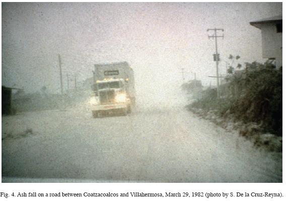
As our group approached the volcano area, through the states of Veracruz and Tabasco, the effects of ashfalls became increasingly evident (Fig. 4). The city of Villahermosa, capital of the Tabasco state, was dark for several days, and the green jungle was mantled by the white–gray ash covering most of eastern Mexico and even ships in the Gulf of Mexico reported ash fall on their decks. We arrived at the volcano area on the afternoon of 29 March, and immediately began to deploy and operate the seismic network around the north sector of the volcano the next day (March 30). In Villahermosa, the state government, through its Ministry of Transport and Communications offered additional logistic help and some personnel to help setting–up the portable seismic network.
Systematic smoking and collection of seismograms on the entire northern portable network was possible by March 31 (Havskov, et al., 1983; Jiménez et al., 1999). Simultaneously, the IINGEN made a similar deployment in the southern sector of the volcano, arriving from central Chiapas. However, the blocked roads and the lack of telephone or radio communications made it impossible to maintain contact between the two portable seismic networks, IINGEN on the south and IGEF on the north. The northern portable network set up headquarters in the town of Teapa, about 36 km from the volcano. Collected seismograms were delivered there and it was the place where information about the other participants and the development of the crisis could be exchanged. It was not until after the eruption ended that the complete set of collected smoked paper seismograms from both portable networks could be analyzed in Mexico City. The initial results of that analysis were reported in Havskov et al, (1983).
It was, however, evident from looking at the seismograms during the first days of the seismic network operation that the eruption had not ended. Even though during the first hours of 30 March the seismograms showed an almost complete seismic quiescence, large–amplitude tremors mixed with LP earthquakes began at about 07:15 of that day (Jiménez et al., 1999). Even cursory examination of the seismograms during the paper–change and lacquer fixing routine, and afterwards, in the Teapa headquarters, showed that this seismic activity continued through the next day producing saturation of the seismograms associated with eruptions occurring at 0900 and 1500 of 30 March, this one lasting until 1900 (Yokoyama et al., 1992, Jiménez et al., 1999). Episodes of LP earthquake warms, smaller amplitude tremors, some of them corresponding to minor eruptions continued from April 1 through early April 3 when this seismic activity stopped. Tremor signals alternated with periods of seismic quiescence followed during the first half of April 3. At least a total of 6 main explosive eruptions took place following the March 28 event (Yokoyama et al., 1992).
On April 3 – 4, the two most violent eruptions occurred, one beginning ~ 1935 on April 3, and another beginning ~ 0520 on April 4. While of short duration (each lasting ~ 2 hours or less), these eruptions were more energetic and voluminous than the 28 March eruption. The April 3 and 4 eruptions produced ash plumes 32 km and 29 km high and copious ashfalls (Macías et al, 1997). Pyroclastic flows and surges swept all flanks of the volcano (Mora, 1983; Sigurdsson et al., 1984, 1987; Carey and Sigurdsson, 1986; Macías et al., 1997). These eruptions killed a large but unknown number of people (later estimated between 1700 and 2300), made more than 20,000 homeless and caused severe economic damage, mostly from cattle stock loss, and extensive damage to the coffee, cocoa and banana plantations.
The March–April eruptions obliterated much of the preexisting summit dome, creating a new crater about 1 km wide and 230 m deep; estimates of the total volume of the eruptions was about 0.5 km3 DRE (Luhr and Varekamp, 1984; Sigurdsson et al., 1984; Macías et al., 1997). Little eruptive activity occurred following the 4 April eruption; the last known ejection of solid material was during a small phreatic ash emission on 11 September 1982. With the onset of the rainy season in mid–April 1982, a number of lahars were generated in several valleys draining the volcano; the largest of which occurred on 26 May 1982, when a natural dam composed of still–hot pyroclastic debris in the Río Magdalena failed catastrophically (Riva Palacio–Chiang, 19983; Macías et al., 2004). Since mid–September 1982, except for a flurry of small rockfalls in June 1992, from the steep walls of the 1982 crater, activity at El Chichón has been restricted to low–level, fluctuating hydrothermal activity in the crater lake (Casadevall et al., 1984; Taran et al., 1998; Armienta et al., 2000).
The disaster
Our first impressions upon arrival (afternoon of 29 March) in the region affected by heavy ashfall, especially south of Villahermosa, were that widespread confusion and disbelief prevailed among all the sectors of society. Visibility was very poor even at midday, highways were closed and many farmers were seen walking from one town to another trying to understand what the situation was. The media was more interested in trying to report a sensational story rather than to get the facts right. Official information was scant, and the perception of the ongoing phenomenon among different officials and the general public varied widely, so that it was difficult to find coincident opinions.
Neither a volcanic emergency plan nor a Civil Protection or Civil Defense organization existed at the time in Mexico. The national Civil Protection System was not created until May 1986, in response to the 1985 Mexico City earthquake. The only emergency plan existing at that time was the Mexican Army DN3 plan, a large–scale response maneuver created in 1966 to help the people in case of disaster. Unfortunately that plan had at that time two serious difficulties (which were later corrected). (1) The plan was mostly designed to deal with the most common hydrometeorological disasters, namely floods, and relied mostly on aerial support by helicopters and fixed–wing aircrafts. This was a consequence of the recent eruptive history of Mexico, lacking a background of major disaster–causing eruptions. The public's perception of volcanic activity was prejudiced by the mild nineteen twenties eruptions of Popocatépetl, Paricutín in 1943, and Colima in 1961 and 1976. Even the VEI 4 Colima volcano eruption of 1913 was not considered a disaster since no confirmed fatalities were reported at the time. (2) The plan could be launched only by presidential order. Problem (1) delayed the full implementation of the plan, because relief personnel and rescue equipment needed to be transported by air to the disaster area, an impossible task with the amount of ash in the air. Thus, the logistics had to be changed to ground operations during the crisis. Problem (2) delayed starting the plan, and the full operation of the Plan actually began on 1 April (DN–III–E, 1983).
As mentioned above, at the time of the first eruption no single decision–making institution existed that could manage the crisis. The only civil office that approximated a disaster–management body at the time was a small administrative unit named "urban emergencies" located in Mexico City, mostly oriented to urban planning. As a consequence, the actions after the initial explosion on March 28 were uncoordinated and chaotic. During the installation of the first seismic stations, and later on, during the daily process of collecting and replacing the smoked paper seismic recordings, it was common to see ash–covered country roads jammed with vehicles with fleeing farmers trying to leave the area and vehicles in the opposite direction driven by people looking for relatives or trying to help an unplanned evacuation (Fig. 5).
Throughout the week of the eruption thousands were evacuated, first disorderly and then in a more organized way after the DN3 plan started operating. The evacuees were transported mostly to the neighboring state of Tabasco. First 29 shelters were installed in schools, and 8 more later were implemented in different cities. The DN–III–E plan evacuated a total of 22352 persons (DN–III–E, 1983).
However, because of the confusion prevailing during the week of the eruptions, not all of the people were evacuated in time, and some evacuees returned to their hometowns before the eruption ended. The main source of this confusion arose from the lack of a single decision–making authority, and of a single scientific opinion on the state of the volcano and on the possible development of the eruption. Although the groups that were operating the seismic networks were certain that the eruption was not over after the 28 March explosion, this opinion was not generally accepted by other scientists. Communication among scientists was inadequate and attempts to convey scientific information to different authorities were not successful. Although the cells of the seismology group could exchange information in the Teapa headquarters, no organized meeting with all other groups involved (e.g., CFE, Government, Army) was possible or encouraged, and each group obtained only a partial view of the eruption development.
Most of the villages such as Guayabal and Colonia el Volcán were nearly abandoned except for the few male farmers who returned to watch over their crops and farm animals. Besides the ash, many of the roofs showed holes from ballistic impacts (Fig. 6). In contrast, to our knowledge, some of the people of Francisco Léon were still in the town which was 5.5 km to the south of the volcano in the path of the surges which occurred on April 3.

Visibility cleared for a few hours on April 2, and we were able to get a view of the cone from Colonia el Volcán, 4 km to the southeast of the crater. Part of the crater dome was gone, expelled during the March 28 eruption. That afternoon only a few men from the village remained there, drinking alcohol to quench their fear. This situation was common in most of the villages surrounding the volcano.
On April 3, at about 1900 hours, we were changing the seismogram at Ostuacán (about 11 km to the northwest of the crater). At 19:35 that night, the seismograph needle suddenly began pounding strongly against the edges of the recording motor, marking the onset of the eruption. Quickly climbing a small hill, we could see and photograph the initial explosion of this eruption (Fig. 7). The intensity of the seismic signal, a strong rumble, the noise of ballistic impacts which dented our vehicle and the strong lightening developing from the eruptive column made us realize that we were witnessing a major eruption. About 20 minutes later, we could see a glowing cloud (Fig. 8) heading our way, slightly to our right. It took a moment to realize that it was a pyroclastic flow. We knew that we were standing at about 11 km from the volcano, but in the darkness and the confusion induced by the heavy pumice fall, it was very difficult to determine the extent of the pyroclastic flow. We returned to the small house that was the Ostuacán City Hall, where the army had setup a headquarters, and discussed the situation with the officer in charge. He instructed his communications officer to contact the main headquarters at Pichucalco by radio. The officer unsuccessfully tried for a long time to contact any other army group. It seems that the static electricity within the volcanic cloud prevented any radio communication.

We decided to split our group, one staying to record the eruption, and the others returning to Teapa to inform about the situation. Minutes later, the ashfall increased its strength, and the lights went off. The one–floor school building in front of the city hall which the army was using as supply storage, collapsed under the weight of the ash and pumice fall. Two soldiers emerged from the wreckage slightly wounded to report to the officer in charge. The few people staying in Ostuacán reacted strangely to this situation. They laughed at these events and joked about the situation.
Afterwards, and for several hours, the ashfall reduced visibility to only a few meters. The rumble and the seismograph permitted us to see the evolution of the eruption. The seismograph remained saturated for about 20 min. Later the signal decreased its intensity. A few hours of relative calm followed, but at 0510 on April 4, another rumbling began, and the seismograph needle started pounding again. This time the seismograph remained saturated for more than two hours. The total darkness caused by the ashfall, which lasted until about 1500 hours of that day made it impossible to see what was happening beyond about 20 meters.
Concluding remarks
The March–April 1982 eruptions produced a large amount of ash fall over a wide area. Villages within 6 km on all sides of the volcano summit were destroyed by pyroclastic flows and surges, killing around 2000 people, even though many villages were already partially abandoned (Fig. 9). These people not only lost their property, and community, they also witnessed how many had been burnt by the flows. A few people were able to survive the surges but later died due to lung complications from ingestion of ash. Many thousands were displaced. After the eruptions the population that was left in the devastated villages was given land further north. Notwithstanding, some have now returned.
Because the repose period between eruptions is longer than a human time scale ( e.g.. Espíndola et al., 2000), the population was not aware of potential hazards posed by El Chichón. Moreover, at the time, there were no Civil protection agencies to coordinate the emergency nor hazard maps and monitoring networks except for those of the CFE designed to observe the recently constructed dams, about 60 km south of the volcano.
El Chichón disaster had several causes, among them the lack of awareness and preparedness of the public and authorities, and the lack of an organized procedure that allowed the exchange of opinions among scientists directed towards the construction of a consensual opinion and consistent recommendations to the authorities.
From many studies made after 1982, the eruptive history of El Chichón is now well known and its volcanic hazards evaluated. Both federal and state Civil Protection agencies now are aware of the volcano risk and additional monitoring is being implemented at the volcano. A permanent telemetred seismic station has been set up near the crater, and two more broad–band stations are to be installed soon at Nicapa and Francisco León (C. Valdés, personal comm.). A 6–vertices EDM baseline geodetic network complemented with 2 GPS reference points has also been set up around the crater, and systematic sampling of the crater lake water has been underway since 1983 (Armienta et al., 2000). The volcanic crisis situations are assessed by appointed scientific committees, where all opinions are discussed collectively and provided to the authorities. Currently, a national Scientific Committee for Geological Risk, appointed by the Ministry of the Interior meets at least once a year, or more frequently if necessary at the National Center for Disaster Prevention (CENAPRED). Locally, a new ruling for the Civil Protection System of the state of Chiapas, foresees appointment of a new State Scientific Committee in 2009. This new structure includes a program to install additional seismic, geodetic and geochemical monitoring at El Chichón and Tacaná volcanoes.
Bibliography
Armienta M. A., S. De la Cruz–Reyna and J. L. Macías, 2000. Chemical characteristics of the crater lakes of Popocatépetl, El Chichón and Nevado de Toluca volcanoes, México. Journal of Volcanology and Geothermal Research, 97, 105–125. [ Links ]
Bernard, P., H. Lyon–Caen, P. Briole, F. Boudin, K. Makropulus, P. Papadimitriou, F. Lemeille, et al., 2006. Seismicity, deformation and seismic hazard in the western rift of Corinth: New insights from the Corinth Rift Laboratory (CRL). Tectonophysics 426, 7–30. [ Links ]
Canul, R. F. and V. L. Rocha, 1981. Informe geológico de la zona geotérmica de "El Chichonal", Chiapas: Comisión Federal de Electricidad, Informe (Unpublished internal report). [ Links ]
Canul–Dzul, R. F., A. Razo–Montiel and V. Rocha–Lopez, 1983. Geologia e Historia –Volcanológica del Volcán Chichonal, Estado de Chiapas. El Volcán Chichonal. Instituto de Geología, Universidad Nacional Autónoma de México. Mexico D. F., p. 3–22. [ Links ]
Carey S. N. and H. Sigurdsson, 1986. The 1982 eruptions of El Chichón volcano, Mexico (2): Observations and numerical modelling of tephra–fall distribution. Bulletin of Volcanology, 48, 2–3, 127–141. [ Links ]
Casadevall, T. J., S. De la Cruz–Reyna, W. I. Rose Jr., S. Bagley, D. L. Finnegan and W. H. Zoller, 1984. Crater lake and post–eruption hydrothermal activity, El Chichón Volcano, Mexico: Journal of Volcanology and Geothermal Research, 23, 1–2, 169–191. [ Links ]
Damon P. and E. Montesinos, 1978. Late Cenozoic volcanism and metallogenesis over an active Benioff Zone in Chiapas, Mexico, Arizona Geological Society Digest, 11, 155–168. [ Links ]
DN–III–E. 1983. El Plan DN–III–E y su aplicación en el área del volcán Chichonal. In: El Volcan Chichonal. Instituto de Geologia, Universidad Nacional Autónoma de México. Mexico D.F., pp 90–99. [ Links ]
Duffield, W. A., R. I. Tilling and R. Canul, 1984. Geology of El Chichón Volcano, Chiapas, Mexico: Journal of Volcanology and Geothermal Research, 20, 117–132. [ Links ]
Espíndola, J. M. J. L. Arce and J. L. Macías, editors, Abstract Volume, El Chichón Volcano. Twenty–five Years Later–A Commemorative Conference (19–25 March 2007, San Cristóbal de las Casas, Chiapas. México): Publicación Especial 6, Universidad Nacional Autónoma de México, 126 pp. [ Links ]
Espíndola J. M., J. L. Macías, R. I. Tilling and M. F. Sheridan, 2000. Volcanic history of El Chichón Volcano (Chiapas, Mexico) during the Holocene, and its impacts on human activity. Bulletin of Volcanology, 62, 2, 90–104. [ Links ]
Figueroa, J., 1973. Sismicidad en Chiapas. Series del Instituto de Ingeniería, Sismología e Instrumentación Sísmica 316. 50 pp. [ Links ]
González–Salazar, A., 1973. Informe preliminar de la zona geotérmica del Volcán Chichonal, Chiapas, Mexico: Comisión Federal de Electricidad. Reporte Interno (unpublished). [ Links ]
Havskov, J., S. De la Cruz–Reyna, S. K. Singh, F. Medina and C. Gutiérrez, 1983. Seismic activity related to the March–April, 1982 eruptions of El Chichón Volcano, Chiapas, Mexico. Geophysical Research Letters, 10, 4, 293–296. [ Links ]
Jiménez, Z., V. H. Espíndola and J. M. Espíndola, 1999. Evolution of the seismic activity from the 1982 eruption of El Chichón Volcano, Chiapas, Mexico. Bulletin of Volcanology, 61, 411–422. [ Links ]
Kraft, T., J. Wassermann, E. Schmedes and H. Igel, 2006. Meteorological triggering of earthquake swarms at Mt. Hochstaufen, SE–Germany. Tectonophysics, 424, 245–258. [ Links ]
Luhr, J. F. and J. C. Varekamp, 1984. Editors, Special Issue on "El Chichón Volcano, Chiapas, Mexico". Journal of Volcanology and Geothermal Research, 23, 1–2, 1–191. [ Links ]
Macías, J. L., M. F. Sheridan and J. M. Espíndola, 1997. Reappraisal of the 1982 eruptions of El Chichón Volcano, Chiapas, Mexico: New data from proximal deposits. Bulletin of Volcanology, 58, 459–471. [ Links ]
Macías, J. L., L. Capra, K. M. Scott, J. M. Espíndola, A. García–Palomo and J. E. Costa, 2004. The 26 May 1982 breakout flows derived from failure of volcanic dam at El Chichón, Chiapas, Mexico: Geological Society of American Bulletin, 116, 233–246. [ Links ]
Matson, M., 1984. The 1982 El Chichón Volcano Eruptions – A Satellite perspective. Journal of Volcanology and Geothermal Research, 23, 1–10. [ Links ]
Miller, S. A., 2008. Note on rain–triggered earthquakes and their dependence on karst geology. Geophys. J. Int. 173, 334–338. [ Links ]
Mota, R., S. De la Cruz and M. Mena, 1984. Enjambres sísmicos en Chiapas: un fenómeno frecuente. GEOS, Boletín de la Unión Geofísica Mexicana, 2, B–17. [ Links ]
Molina–Berbeyer, R., 1974. Informe preliminar de geoquímica de los fluidos geotérmicos del Volcán Chichonal, Chiapas: Comisión Federal de Electricidad, Informe (Unpublished internal report). [ Links ]
Müllerried, F. K. G., 1933. El Chichón. Unico volcán en actividad en el sureste de México. Rev. Inst. Geol. Mex., 33, 156–170. [ Links ]
Riva Palacio–Chiang, R., 1983. Informe y comentarios acerca del Volcán Chichonal, Chiapas, in Alcayde, M., 1983, editora, El Volcán Chichonal, Ponencias presentadas en el simposio sobre el Volcán Chichonal, VI Convención Geológica Nacional de la Sociedad Geológica Mexicana: Instituto de Geología, UNAM, México, D.F., p. 49–56. [ Links ]
Rodríguez R., 1977. Enjambre de temblores ocurrido en Chiapa de Corzo, Chiapas, 1975. Resultados Sismológicos. Tesis Lic. Física, Fac. de Ciencias, UNAM. 55 pp. [ Links ]
Sigurdsson, H., S. N. Carey and J. M. Espíndola, 1984. The 1982 eruptions of El Chichón Volcano, Mexico: Stratigraphy of pyroclastic deposits. Journal of Volcanology and Geothermal Research, 23, 1–2, 11–37. [ Links ]
Sigurdsson, H., S. N. Carey and R. V. Fisher, 1987. The 1982 eruptions of El Chichón volcano, Mexico (3): Physical properties of pyroclastic surges: Bulletin of Volcanology, 49, 2, 467–488. [ Links ]
Silva–Mora, L., 1983. La erupción del Volcán Chichonal, Chiapas: Una particularidad del Vulcanismo en México in Alcayde, M., 1983, editora. El Volcán Chichonal, Ponencias presentadas en el simposio sobre el Volcán Chichonal, VI Convención Geológica Nacional de la Sociedad Geológica Mexicana: Instituto de Geología, Universidad Nacional Autónoma de México. México D.F., pp. 23–35. [ Links ]
Taran, Y., T. P. Fischer, B. Pokrovsky, Y. Sano, M. A. Armienta and J. L. Macías, 1998. Geochemistry of the volcano–hydrothermal system of El Chichón Volcano, Chiapas, Mexico. Bulletin of Volcanology. 59, 436–449. [ Links ]
Yokoyama, I., S. De la Cruz–Reyna and J. M. Espíndola, 1992. Energy partition in the 1982 eruption of El Chichón volcano, Chiapas, Mexico. Journal of Volcanology and Geothermal Research, 51, 1–21. [ Links ]

