


Services on Demand
Journal

Article
 English (pdf)
 Article in xml format
 Article references
 Send this article by e-mail
Indicators
 Cited by SciELO
 Related links
-
 Similars in
SciELO
Similars in
SciELO
Share

 Permalink
Geofísica internacional
On-line version ISSN 2954-436XPrint version ISSN 0016-7169
Geofís. Intl vol.47 n.1 Ciudad de México Jan./Mar. 2008
Short notes
Comparison of elevation heights using a Differential Global Positioning System (DGPS) and a Total Station
L. E. Marín1*, M. Balcazar2, M. Ortiz3, B. Steinich4, J. A. Hernández–Espriu2
1 Depto. de Recursos Naturales, Instituto de Geofísica, Universidad Nacional Autónoma de México, Mexico City, Mexico. * Corresponding author: lmarin@geofisica.unam.mx
2 Facultad de Ingeniería, Universidad Nacional Autónoma de México, Mexico City, Mexico
3 Posgrado en Ciencias de la Tierra, Universidad Nacional Autónoma de México, Mexico City, Mexico
4 Independent Consultant
Received: September 27, 2007
Accepted: October 30, 2007
Resumen
Diferencias en elevación en un juego de 12 puntos diferentes fue determinado utilizando dos técnicas diferentes: estación total y un sistema de GPS diferencial (utilizando tres receptores con tiempos de ocupación de 90 minutos por estación). Una comparativa entre los dos juegos de valores de la elevación dan una diferencia que varía de dos a 36 mm para una línea base de máximo 2,420 metros de distancia. Estos resultados demuestran que los levantamientos utilizando el sistema de GPS diferencial pueden ser utilizados para realizar nivelaciones utilizando dicha técnica.
Palabras clave: Sistema de posicionamiento global, estación total, levantamiento.
Abstract
Differences in elevation for a set of 12 different points were determined using a Total Station and a DGPS three receivers with occupation times of 90 minutes per station). A comparison between both sets of elevation values shows differences of two to 36 millimeters for a maximum baseline of 2,420 meters. These results show that differential GPS surveys may be used to determine differences in elevation using the differential GPS technique.
Key words: Differential Global Positioning System; total station, surveying.
Introduction
Instituto Nacional de Estadística, Geografía e Informática (INEGI) maintains a first–order network of geodetic benchmarks in Mexico (INEGI, 2000). They have produced a digital terrain model for Mexico, with errors that can be as high as tens of meters (S. Peña, oral com.). Vertical control is essential for the geosciences, including hydrogeology. Marín and others (1998) found that the vertical errors using a hand–held GPS are greater than 100 meters. Marín and et al. (2005) conducted a study to determine the precision on the vertical axis using a Differential Global Positioning System. The Global Positioning System has been used extensively in geodesic issues, such as crustal deformation, and plate tectonics (Cabral–Cano, 2007). Geodetic surveys typically call for permanent stations, or use long occupation times. Engineering studies, on the other hand, typically use very short occupation times. In this paper, we conduct a comparison between a survey carried out using a Total Station and a DGPS survey.
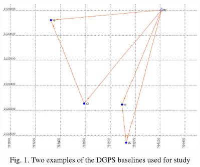
We determined the elevation difference between an arbitrary benchmark and 12 different points using both a DGPS and a Total Station. An arbitrary starting point, V2, was tied to a local datum. The topography of the study area is slightly hilly, with maximum differences in the vertical axis less than 30 meters. The maximum distance between any two measurement points was less than four kilometers.
A Differential Global Positioning System Total Station was used which consists of two base receivers (Trimble model 4700) and a rover (Trimble model 4800). All three receivers are dual frecuency receivers. For the base receiver, a tripod with three preset heights was used 1.80, m). Three receivers were used for all measurements, as suggested by Marín et al. (2005), The maximum distance between two receivers was less than 2,500 meters. The control point consists of a benchmark cemented on–site. Occupation times for all three receivers werel80 minutes. Data logged in the receivers were downloaded to a computer for post–processing after every measurement period. The Trimble Geomatics Office (TGO, 1999) software was used to process the data. Predicted orbits obtained from the satellites were used. The DGPS baselines were processed and they passed the quality control imposed by the TGO software.
The results of the DGPS and Total station surveys are presented in Table 1.

Table 1 shows the differences between the elevation heights obtained with the total station and with the DGPS range differences are between two and 36 millimeters. These results show that elevations can be obtained using a differential GPS survey technique with three receivers, and that the technique can be used to determine elevations above mean sea level.
Conclusions
Elevations using both a Total Station and three GPS receivers with post–processing were obtained. Differences in value were below 36 millimeters. The elevations obtained with the total station were consistent with those obtained with GPS receivers. Previous work by Marín and others (2005) using two receivers yielded a maximum error of 60 cm in the vertical axis. The technique described here reduced the error in the vertical axis by more than one order of magnitude.
These results are important for areas where there is a lack of first–order benchmarks, or where benchmarks have been destroyed or removed. Determination of elevations for regional studies can be conducted using the technique described here, and the technique will help reduce the uncertainty in digital terrain models in Mexico.
Acknowledgements
Marín and Steinich acknowledge a grant by the Dirección General de Asuntos del Personal Académico of the Universidad Nacional Autónoma de México.
Bibliography
Cabral–Cano, E., T. H. Dixon, O. Sánchez and O. Díaz–Molina, 2007. A New Apporach to an Old Problem: Space Geodetic Imaging of Ground Subsidence In Mexico City, Geology, Submitted. [ Links ]
INEGI, 2000. La Nueva Red Geodésica Nacional, una visión hacia el futuro, Aguascalientes, Aguascalientes, México, 29 p. [ Links ]
Marín, L. E., X. Peréz and E. Rangel, 1998. Comparison of three surveying techniques and its applications to hydrogeological studies: level, barometer, and GPS. Geofísica Internacional, 37, 127–129. [ Links ]
Marín, L. E., B. Steinich and O. A. Escolero E, 2005. Precision Estimates for Ellipsoidal Height Determinations for Short Baselines using a DGPS System. Geofísica Internacional, 44(4), 391–394. [ Links ]

