


Serviços Personalizados
Journal

Artigo
 Inglês (pdf)
 Artigo em XML
 Referências do artigo
 Enviar este artigo por email
Indicadores
 Citado por SciELO
 Links relacionados
-
 Similares em
SciELO
Similares em
SciELO
Compartilhar

 Permalink
Geofísica internacional
versão On-line ISSN 2954-436Xversão impressa ISSN 0016-7169
Geofís. Intl vol.46 no.4 Ciudad de México Out./Dez. 2007
Article
Environmental characterization of the continental shelf of the Gulf of Tehuantepec, Mexico
M. Tapia–García1,*, M. C. García–Abad1, A. Carranza–Edwards2 and F. Vázquez–Gutiérrez2
1 Departamento de Hidrobiología, Universidad Autónoma Metropolitana–Iztapalapa, A.P. 55–535. Av. San Rafael Atlixco 186, Col. Vicentina, Tel 58046492, Fax 58044738, 09340 Mexico City, México. * Corresponding author: mtg@xanum.uam.mx
2 Instituto de Ciencias del Mar y Limnología, Universidad Nacional Autónoma de México, A.P.70–305, Del. Coyoacán, 04510 México City, México
Received: February 20, 2007
Accepted: May 8, 2007
Resumen
Se analizan datos e información de las características fisco–químicas del agua y tipo de sedimentos de la plataforma continental del Golfo de Tehuantepec, México. Los cambios de salinidad, temperatura y oxígeno disuelto varían de acuerdo con las estaciones de lluvias y sequía (en esta última prevalecen fuertes vientos denominados Tehuantepecanos). Las estaciones de muestreo fueron agrupadas (utilizando salinidad, temperatura, pH y tipo de sedimentos) con análisis por conglomerados y análisis de factores. Los resultados indican que el Golfo de Tehuantepec tiene dos subsistemas. El subsistema Oaxaqueño se localiza frente a la zona entre Salina Cruz y la boca de Tonalá y se extiende hacia el sur–sudeste; este subsistema se caracteriza por presentar surgencias que producen valores bajos de temperatura, oxígeno disuelto y altas concentraciones de nutrimentos, escasas descargas de ríos y sedimentos arenosos. El subsistema Chiapaneco se localiza frente a la zona entre la boca de Tonalá y el río Suchiate, con fuerte influencia de lagunas costeras y descargas de ríos; se caracteriza por sedimentos arenosos y lodoso–arenosos, y no presenta surgencias. Estos subsistemas y sus características probablemente determinan el patrón de distribución de los recursos bióticos.
Palabras clave: Física, química, Chiapas, Oaxaca, Tehuantepec, sedimentos, surgencias.
Abstract
This study analyzes data and information of the physical and chemical characteristics of water, and type of sediments of the continental shelf of the Gulf of Tehuantepec, Mexico. The changes of salinity, temperature, and dissolved oxygen fluctuate according to the wet and dry seasons (in the last one, prevails the Tehuantepecanos winds). The stations samples of salinity, temperature, pH, and type of sediments were classified by cluster and factor analysis. The results suggest that the Gulf of Tehuantepec has two subsystems. The Oaxaqueño subsystem extends south–southeast from Salina Cruz to the Tonala inlet. This subsystem is characterized by upwelling periods, which leads to low temperatures, low dissolved oxygen and high nutrient concentration, as well as sandy sediments and insignificant river discharges when low temperature, low dissolved oxygen and high nutrient concentration are typical, and by sandy sediments and insignificant river discharges. The second, the Chiapaneco subsystem, is located between the Tonala inlet and the Suchiate River, with strong influence of coastal lagoons and river discharges. The bottom is characterized by sandy and muddy–sand sediments. This subsystem is not affected by either Tehuantepecanos winds or upwelling. Both subsystems and their characteristics probably determine the patterns of distribution of the biotic resources.
Key words: Physics, chemistry, Chiapas, Oaxaca, Tehuantepec, sediments, upwelling.
Introduction
There is available literature on the Gulf of Tehuantepec that describes the general processes that occur in the gulf and how they determine the distribution patterns of the biotic resources (Tapia–Garcia, 1998). We identified the necessity to analyze the physical and environmental dynamics of the region to determine possible environmental subsystems, and their spatial and temporal variability, as a basis for future assessment of changed patterns of natural resources in the Gulf. Hence, the main objective of this work is to characterize the Gulf of Tehuantepec with relation to the environmental dynamics. This will be done by integrating previous results, with physical and chemical data generated by the authors of the present work.
Study area and methodology
The study area includes the continental shelf of the Gulf of Tehuantepec adjacent to the coasts of Oaxaca and Chiapas states (96°7'30'' and 92°14'30'' W, and 14°30'15'' and 16°13' N). The area is comprised between Huatulco bays (Oaxcaca) and the Suchiate River (Chiapas) (Figure 1). According to Garcia (1981), the region has a sub humid warm climate, with abundant rains in summer (at least 10 times greater in the most humid month compared to the driest month). Two climatic seasons are distinguished, the dry season (October–November to April–May) and the rainy season (May–June to October). The northern winds occur during the dry season (they are known as "Northerns" in the Gulf of Mexico; in the isthmus are called "Tehuanos", "Tehuantepecos" or "Tehuantepecanos"). These winds are a large scale result of meteorological phenomena affected by the local topographic characteristics as described by Hurd (1929), Roden (1961), Blackburn (1963), Clarke (1988), McCreary et al. (1989), Lavin et al. (1992), and Monreal–Gomez and Salas de Leon (1998), Chelton et al. (2000), Romero Centeno et al. (2003), Gonzalez–Silvera et al. (2004). When the Tehuantepecanos winds leave the coast, they produce a violent spurt, and afterwards their speed is reduced as they expand horizontally and towards the sea, affecting an approximate area of 200 km wide and 500 km long. When the wind blows on the surface of the sea, it pushes the water and forms a convergence zone, which determines the collapse of the thermocline (Monreal–Gomez and Salas de Leon, 1998). A divergence zone occurs towards the east of the winds zone. The divergence zone produces an elevation of the thermocline (Lavin et al., 1992; Gallegos–Garcia and Barberan–Falcon, 1998). This divergence carries nutrients towards the surface, increasing primary production (Lluch et al., 1997; Lara–Lara et al., 1998).
During the summer the winds are generally weak, and the surface currents have a direction of West–Northwest, with speeds of 5 cm/s, and surface temperatures between 28 °C and 30 °C (Hurd, 1929; Roden, 1961; Molina Cruz and Martinez Lopez, 1994). There are several coastal lagoons and rivers in the Gulf of Tehuantepec that discharge mainly on the coast of Chiapas. They exceed 1500 million m3/year of draining water (Morales de la Garza, 1990).
Databases corresponding to May, August and November were taken from Vazquez Gutierrez et al. (1990, 1998), Turner Garces (1992) and Salvador Lopez (1993) to obtain the seasonal analysis of salinity, temperature, pH and dissolved oxygen. The data reported by the Institute of Marine Research (1988), that covered the months March, June and December, and by Secretaria de Marina (1980) for September were analyzed. We got the average, the maximum and minimum values per month to be plotted. Carranza–Edwards et al. (1998) and Morales de la Garza (1990) reported the sediments data (Table 3).

The physical data, the chemical data (Tables 1 and 2, Figure 1) and the type of sediments (Table 3) were grouped to determine different geographical areas and their seasonal variation. To establish the group classes we used the Factor Analysis by Principal Components and the Cluster Analysis (Ward, 1963) through "STATISTICA" for Windows version 5.1, StatSoft, Inc., 1998. For this analysis, the available data were at levels of 5 m, 10 m and 50 m of depth. For the description in the maps, the groups of classified stations were mapped using the average geographical distance between the groups.


Results
At 10 m depth, salinity ranged from 33.00 to 34.75 with the lowest average values from June to November, and the highest in December, March and May. At 50 m depth, the variation was from 33.05 to 34.90 with the lowest average values from June to November; in the remaining months the salinity average was higher. The salinity variation was greater at 10 m depth than 50 m depth. November was the month that presented the largest variation of salinity (s.d.=0.5 at 10 m depth; s.d.=1.1 at 50 m depth) (Figure 2).

The variation of average temperature at 10 m level ranged 14 to 31 °C. At 50 m depth, the variation was from 11.9 to 29.8 °C, with the lowest average values recorded from November to May and the highest from June to September. The variation of temperature was higher at 50 m depth compared to the 10 m level. Generally, temperature was higher at 10 m, and November was the month with the largest variation of temperature (s.d.=5.04 at 50 m) (Figure 2).
In general, dissolved oxygen was higher in surface waters (10 m) than at 50 m depth. The values varied from 0.5 ml/l in March (50 m depth) to 6.0 ml/l in September (10 m depth). The average annual variation at 50 m indicates the highest concentration in June (4.2 ml/l). After June, there is a decreasing trend reaching the lowest average value in December (1.2 ml/l) (Figure 2).
Two groups of sampling stations were identified as a result of the cluster and factor analysis of salinity, temperature and pH, in May (5 m depth). One group includes most of the continental shelf at less 80 m depth. The second group corresponds to the stations nearby the San Francisco inlet (Inferior Lagoon), the Tonala inlet (Mar Muerto Lagoon) and the "El Cielo" inlet (La Joya Lagoon) (Figure 3). Also, two groups of stations were observed at 10 m depth. At 50 m depth, the two groups of stations observed indicated a classification between coastal waters and those that are towards to the open sea (Figure 3). In November, the factor analysis at a level of 5 m depth also showed the presence of two groups of stations (Figure 4). The analysis at 50 m depth showed a similar result to the 5 m level.
The map of sediments distribution reported by Carranza–Edwards et al. (1998), based on percent of mud (silt and clay), showed that the sand (less than 10% of mud) has a northwest–southeast trend, with muddy sands engulfing it. The cluster analysis on the type of sediments indicated that for depths less than 80 m there are two groups of stations according to the sedimentary fractions of two areas. The largest area is located mainly in the northwest of the gulf, composed mainly of sandy sediments. The second area represents an admixture of sandy mud and muddy sand surrounding the sand zone shown in Figure 5. This is reflected in the sedimentological subsystem derived by factor analysis. It is evident that the small eastern area, close to land, has a different pattern due to the high humidity and weathered lands, which are not affected by strong northern winds.

Discussion and conclusions
The variation of the abiotic parameters reflects the seasonal changes of the Gulf of Tehuantepec. Salinity is lower than 34.5, due to the direct influence of the Costa Rica Current, which is a result of the Equatorial Counter Current where low values of salinity and high values of temperature are determined by the meteorological equator, where the rainfall is abundant (Molina–Cruz and Martinez–Lopez, 1994; Monreal–Gomez and Salas de Leon, 1998). The lower salinity corresponds to the rainy season (June–November), and the higher salinity corresponds to the dry season–Tehuantepecanos winds (November–May), when the epicontinental discharge diminishes, and upwelling occurs as a result of the Tehuantepecanos winds (Lavin et al., 1992; Monreal–Gomez and Salas de Leon, 1998). Therefore, November is the month with the greatest variation of salinity.
The variation of water temperature also indicates seasonal changes in the region, with the lowest values during the dry season–Tehuantepecanos winds, and the highest values during the rainy season. The lowest average values from November to May (dry season–Tehuantepecanos winds) are determined by the upwelling (Alvarez et al., 1989; Lavin et al., 1992; Monreal–Gomez and Salas de Leon, 1998). The highest average values, from June to November, are determined by the end of the Tehuantepecanos winds and the upwelling, as reported by Roden (1961), Legeckis (1978), Alvarez et al. (1989) and Lavin et al. (1992). The greatest variation of temperature in November is an indicator of the end of the rainy season and the beginning of the upwelling period.
The high concentration of oxygen and the low concentration of nutrients in surface waters during the end of the dry season and during the beginning of the rainy season (March, May) indicates the great photosynthetic activity in surface waters and the ocean–atmosphere interaction, as reported by Turner–Garces (1992), Lluch–Cota et al. (1997) and Vazquez Gutierrez et al. (1998). The low concentration of oxygen and the high concentration of nutrients in surface waters during the dry season–Tehuantepecanos winds are a result of the upwelling. This process determines high primary production (Robles Jarero and Lara–Lara, 1993; Lluch–Cota et al., 1997; Lara Lara et al., 1998). This is reflected in the availability of nutrients (Turner–Garces, 1992; Vazquez Gutierrez et al., 1998).
The classifications obtained through cluster and factor analysis including salinity, temperature and pH were similar, and they showed the environmental behavior described previously. In May, it is evident that the inner shelf is influenced by epicontinental discharges, and there is a clear separation between the coastal waters (inner shelf) and the outer shelf, revealing the important influence of coastal processes.
In November, the classifications indicate clearly the effect of the upwelling on a broad strip located between Salina Cruz and the Tonala inlet, and towards the open sea (to the south). The upwelling determines higher values of nutrients, salinity and pH, and lower values of oxygen and temperature in the central and northern part of the Gulf. The influence of the coastal processes towards the west of the Gulf and towards the southeastern part (coast of Chiapas) results in lower values of nutrients, salinity and pH, and higher values of oxygen and temperature. The characteristics of the water masses and their distribution in the Gulf have a similar pattern to the distribution of temperature values as observed in the satellite images of the Gulf of Tehuantepec reported by Lavin et al. (1992), Gallegos–Garcia and Barberan–Falcon (1998), and Martinez–Diaz–de–Leon et al. (1999). The pattern observed during the dry season in relation to the upwelling is reversed during the rainy season with higher values of nutrients (Vazquez Gutierrez et al. 1998) and temperature, and lower values of salinity and pH near to the coast.
The grouped stations through cluster analysis of the sediments, at depths deeper than 100m, reflect the dynamics of the masses of water. Towards the north–northwest shallow waters of the Gulf (in front of the Superior–Inferior Lagoons), there are sandy sediments in the continental shelf of the Gulf of Tehuantepec. Scarce amount of mud indicates low epicontinental discharges, as well as high energy due to the strong Tehuantepecanos winds that transport sands towards the coast and the sea. In this area, Molina–Cruz and Martinez–Lopez (1994) reported the presence of radiolarians. According to Carranza–Edwards et al. (1989, 1998), Morales de la Garza (1990) and Daessle and Fischer (2001), in this area there are two particular shallow zones characterized by the presence of muddy sands, sandy mud and phosphorite nodules as an evidence of upwelling. These zones were previously named Oaxaqueño Bank and Chiapaneco Bank by Carranza Edwards et al. (1989). The Chiapaneco Bank corresponds to the southeastern part of the upwelling zone (to the east of the wind spurt), and the Oaxaqueño Bank corresponds directly to the upwelling induced by wind. The other area is constituted by muddy sand, sandy–mud and sand with some gravel, which is determined mainly by the influence of the coastal lagoons located in the southeastern part of the Gulf and corresponds to the inner continental shelf of the Chiapas coast (Figure 5). The lower values of salinity determine the absence of radiolarians as reported by Molina Cruz and Martinez–Lopez (1994).
The continental shelf of the gulf can be divided in two main areas, one corresponding to the coast of Oaxaca, and the other to the coast of Chiapas. These areas are related to the dynamic of two main masses of water determined by the Costa Rica Current–epicontinental discharges towards the continental shelf and by the upwelling caused by the Tehuantepecanos winds, and the seasonal variation –rainy and dry seasons.
It was concluded that the continental shelf of the Gulf of Tehuantepec might be divided in two main dynamic subsystems in relation to the hydrology and sedimentology; one corresponding to the Oaxaca coast and the other to the Chiapas coast with a variable boundary between both of them. We propose a conceptual model of the "Oaxaqueño Subsystem" and the "Chiapaneco Subsystem" (Figure 6), which can be summarized as follows:
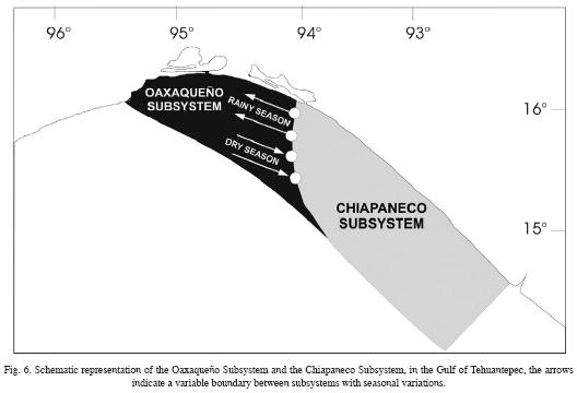
1. Oaxaqueño Subsystem: It corresponds to the continental shelf of Oaxaca, between Salina Cruz and the Tonala inlet, and it extends to the south–southeast (Figure 6). The upwelling and downwelling determine this subsystem in the dry season as a result of the Tehuantepecanos winds. There are low temperatures, high concentration of nutrients, low values of dissolved oxygen, and high salinity and pH. The sediments are mainly sandy. The Oaxaqueño and Chiapaneco Banks, described by Carranza Edwards et al. (1989, 1998), and the area of distribution of radiolarians, named "upwelling assemblage" by Molina–Cruz and Martinez–Lopez (1994), are included in this subsystem.
2. Chiapaneco Subsystem: It corresponds to the inner continental shelf of Chiapas, between the Tonala inlet and the Suchiate River (on the border with Guatemala) (Figure 6). The Costa Rica Current influences this subsystem. Also, it has strong influence of the epicontinental processes such as freshwater discharges of coastal lagoons and riverine systems (associated to the outflow of higher concentration of nutrients), with lower salinity and pH, and higher values of dissolved oxygen and temperature, mainly during the rainy season. The sediments are sandy–mud or sand with minor quantities of gravel. There is an absence of radiolarians as a result of the lower salinity (Molina–Cruz and Martinez–Lopez, 1994).
These subsystems and their characteristics probably determine the distribution patterns of the biotic resources. Further research is necessary to verify this hypothesis in order to establish these subsystems as ecological subsystems.
Acknowledgments
We appreciate the support given in textural analysis by E. A. Morales de la Garza. Thanks to the authorities of the Universidad Autónoma Metropolitana and the Universidad Nacional Autónoma de México for their important support. We thank the reviewing and the important comments and suggestions of Dr. Miguel Lavin.
Bibliography
Alvarez, L. G., A. Badan–Dangon and A. Valle, 1989. On coastal currents of Tehuantepec. Estuar. Coast. Shelf Sci, 29, 89–96. [ Links ]
Blackburn, M., 1963. Distribution and abundance of tuna related to wind and ocean conditions in the Gulf of Tehuantepec, Mexico. FAO Fish. Rep., 3(6), 1557–1582. [ Links ]
Carranza–Edwards, A., 1987. Informe técnico de la campaña oceanográfica MIMAR III. Inst. Cienc. del Mar y Limnol., UNAM, México. 95 p. [ Links ]
Carranza–Edwards, A., L. Rosales Hoz, E. Ruíz Ramírez and S. Santiago Pérez, 1989. Investigations of phosphorite deposits in the Gulf of Tehuantepec, Mexico. Mar. Min., 8, 317–1998. [ Links ]
Carranza–Edwards, A., E. Morales de la Garza and L. Rosales Hoz, 1998. Tectonics, sedimentology and geochemistry. In: M. Tapia–Garcia (Ed.), El Golfo de Tehuantepec: el ecosistema y sus recursos, Universidad Autónoma Metropolitana–Iztapalapa, México, 1–11. [ Links ]
Clarke, A. J., 1988. Inertial wind path and sea surface temperature patterns near the Gulf of Tehuantepec, Mexico and Gulf of Papagayo. J. Geophys. Res., 93, 5491–5501. [ Links ]
Chelton, D. B., M. H. Freilich and S. K. Esbensen, 2000. Satellite observations of the wind jets off the Pacific coast of Central America. Mon. Weather Rev., 128(7), 1993–2018. [ Links ]
Daessle, L. W. and D. W. Fischer, 2001. Marine Minerals in the Mexican Pacific: Toward Efficient Resource Management. Mar. Georesour. Geotechnol., 19(3), 197–206. [ Links ]
Gallegos Garcia, A. and J. Barberan Falcon, 1998. Wind–induced upwelling. In: M. Tapia–Garcia (Ed.), El Golfo de Tehuantepec: el ecosistema y sus recursos, Universidad Autónoma Metropolitana–Iztapalapa, México, 27–34. [ Links ]
Garcia, E., 1981. Modificaciones al sistema de clasificacion climatica de Koppen. Talleres Larios, S. A. México. [ Links ]
Gonzalez–Silvera, A., E. Santamaria–del–Angel, R. Millan–Nuñez and H. Manzo–Monroy, 2004. Satellite observations of mesoscale eddies in the Gulfs of Tehuantepec and Papagayo (Eastern Tropical Pacific). Deep Sea Res., 51(6–9), 587–600. [ Links ]
Hurd, W. E., 1929. Northers of the Gulf of Tehuantepec. Mon. Weather Rev., 57(5), 192–194. [ Links ]
Institute of Marine Research, 1988. Informe final "Prospecciones de los recursos pesqueros de la plataforma pacífica entre el sur de México y Colombia, 1987". Bergen. [ Links ]
Lara–Lara, J. R., E. G. Robles Jarero, M. C. Bazan Guzman and E. Millan Nuñez, 1998. Phytoplankton productivity. In: M. Tapia–Garcia (Ed.), El Golfo de Tehuantepec: el ecosistema y sus recursos, Universidad Autónoma Metropolitana–Iztapalapa, México, 51–58. [ Links ]
Legeckis, R., 1978. A survey of worldwide sea surface temperature fronts detected by environmental satellites. J. Geophys. Res. 83 (C9), 4501–4522. [ Links ]
Lavin, M. F., J. M. Robles, M. L. Argote, E. D. Barton, R. Smith, J. Brown, M. Kosro, A. Trasviña, H. S. Velez and J. García, 1992. Física del Golfo de Tehuantepec. Cienc. Desarr., 18(103), 97–107. [ Links ]
Lluch–Cota, S. E., S. Alvarez–Borrego, E. M. Santamaria–del–Angel, F. E. Mueller–Karger and S. Hernández–Vazquez, 1997. El Golfo de Tehuantepec y áreas adyacentes: Variación espacio–temporal de pigmentos fotosintéticos derivados de satélite. Cienc. Mar., 23(3), 329–340. [ Links ]
Mccreary, J. P., H. S. Lee and D. B. Enfield, 1989. The response of the coastal ocean to strong offshore winds: with application to circulation in the Gulf of Tehuantepec and Papagayo. J. Mar. Res., 47, 81–109. [ Links ]
Martinez–Diaz–de–Leon, A., I. S. Robinson, D. Ballestero and E. Coen, 1999. Wind driven ocean circulation features in the Gulf of Tehuantepec, Mexico, revealed by combined SAR and SST satellite sensor data. Int. J. Remote Sens., 20, 1661–1668. [ Links ]
Molina–Cruz, A. and M. Martínez Lopez, 1994. Oceanography of the Gulf of Tehuantepec, Mexico, indicated by Radiolaria remains. Palaeogeogr. Palaeoclimatol. Palaeoecol., 110, 179–195. [ Links ]
Monreal Gomez, M. A. and D. A. Salas De León, 1998. Dynamic and termohaline structure. In: M. Tapia–Garcia (Ed.), El Golfo de Tehuantepec: el ecosistema y sus recursos, Universidad Autónoma Metropolitana–Iztapalapa, México, 13–26. [ Links ]
Morales de la Garza, E. A., 1990. Estudio de sedimentos fosfatados en el Golfo de Tehuantepec, Mexico. Tesis de Maestría, Instituto de Ciencias del Mar y Limnologia, UNAM. [ Links ]
Morales de la Garza, E. A. and A. Carranza–Edwards, 1995. Sedimentos fosfatados en el Golfo de Tehuantepec. Hidrobiologica, 5(1–2), 25–36. [ Links ]
Robles Jarero, E. G. and J. R. Lara–Lara, 1993. Phytoplankton biomass and primary productivity by size classes in the Gulf of Tehuantepec, Mexico. J. Plankton Res., 12, 1341–1358. [ Links ]
Roden, G. I., 1961. Sobre la circulación producida por el viento en el Golfo de Tehuantepec y sus efectos sobre las temperaturas superficiales. Geofísica Internacional, 3, 55–72. [ Links ]
Romero–Centeno, R., J. Zavala–Hidalgo, A. Gallegos and J. J. O'Brien, 2003. Isthmus of Tehuantepec wind climatology and ENSO signal. J. Clim., 16(15), 2628–2639. [ Links ]
Salvador–Lopez, G., 1993. Estudio del sistema del dióxido de carbono en el Golfo de Tehuantepec, durante la época de lluvias (1990–1). Tesis en Biología, Escuela Nacional de Estudios Profesionales–Zaragoza, UNAM. [ Links ]
Secretaría de Marina, 1980. Estudio oceanográfico del Golfo de Tehuantepec. Dirección General de Oceanografía, Talleres de la Nación, México. [ Links ]
Tapia Garcia, M. (Ed.), 1998. El Golfo de Tehuantepec: el ecosistema y sus recursos, Universidad Autónoma Metropolitana–Iztapalapa, México, 239 p. [ Links ]
Turner–Garces, M., 1992. Estudio oceanográfico de algunos parámetros físicos y químicos de la zona de surgencia del Golfo de Tehuantepec en los meses de mayo y noviembre de 1989. Tesis de Licenciatura en Biología. Escuela Nacional de Estudios Profesionales–Zaragoza, UNAM. [ Links ]
Vazquez Gutierrez, F., H. Alexander, M. Turner, H. Delgado, R. Diaz and C. Ruiz, 1990. La costa de Chiapas, parámetros fisicoquímicos de la calidad de sus aguas. Revista de Difusión Científica–Tecnológica y Humanística, Tuxtla Gutiérrez, Chiapas, 1, 65–68. [ Links ]
Vazquez Gutierrez, F., G. Salvador Lopez, A. Ramirez Alvarez, M. Turner Garces, A. Frausto Castillo and H. Alexander Valdez, 1998. Water chemistry. In: M. Tapia–Garcia (Ed.), El Golfo de Tehuantepec: el ecosistema y sus recursos, Universidad Autónoma Metropolitana–Iztapalapa, México, 35–50. [ Links ]
Ward, J., 1963. Hierarchical grouping to optimize an objective function. J. Amer. Statistic. Ass., 58, 236–244. [ Links ]

