


Servicios Personalizados
Revista

Articulo
 Inglés (pdf)
 Artículo en XML
 Referencias del artículo
 Enviar artículo por email
Indicadores
 Citado por SciELO
 Links relacionados
-
 Similares en
SciELO
Similares en
SciELO
Compartir

 Permalink
Geofísica internacional
versión On-line ISSN 2954-436Xversión impresa ISSN 0016-7169
Geofís. Intl vol.46 no.2 Ciudad de México abr./jun. 2007
Tidal Current Components in the Southern Bay of Campeche, Gulf of Mexico
David A. Salas–de–León1, María A. Monreal–Gómez1, David Salas–Monreal2, Gilberto Expósito–Díaz1, Mayra L. Riverón–Enzastiga1 and Felipe Vázquez–Gutiérrez1
1 Instituto de Ciencias del Mar y Limnología, Universidad Nacional Autónoma de México, Cd. Universitaria, Del. Coyoacán, 04510 Mexico City, Mexico. E–mail: salas@mar.icmy.unam.mx
2 Centro de Ecología y Pesquerías, Universidad Veracruzana, Hidalgo 617, Col. Río Jamapa, Boca del Río, 94290 Veracruz, México.
Received: March 17, 2006
Accepted: May 17, 2007
Resumen
Datos sobre la magnitud y dirección de las corrientes fueron obtenidos en la Bahía de Campeche, al sur del Golfo de México, de marzo a mayo de 1997, para obtener las principales componentes de marea en la región. Las elipses y fases de las diferentes componentes de marea fueron obtenidas mediante un ajuste por mínimos cuadrados acoplado con una modulación nodal a partir de las series horarias de corrientes por marea. Los constituyentes P1 y K2 se infirieron a partir de los constituyentes K1 y S2, respectivamente. Los resultados muestran la dominancia del armónico K1 en la plataforma continental al sur de la Bahía de Campeche, una región de mareas mixtas con dominancia semidiurna en la zona del umbral de Cayo Arcas y una región de transición entre Cayo Arcas y las estaciones al oeste en la zona de estudio. Las diferencias en las amplitudes de las corrientes de marea en la vertical fueron despreciables, mientras que las diferencias en las fases muestran un retraso significativo entre la superficie y el fondo. El sentido de rotación de las elipses de marea en Cayo Arcas es negativo, mientras que en las otras estaciones fue positivo. Cayo Arcas tiene una fuerte influencia en las corrientes de marea ya que su fase y sentido de rotación varían.
Palabras clave: Corrientes de marea, armónicos de marea, Bahía de Campeche, Golfo de México
Abstract
Current velocity data in the Southern Bay of Campeche, Gulf of Mexico, were obtained from March 1997 to May 1997, in order to compute tidal ellipses and phase lags in the region. Tidal ellipses and phase lags were calculated via a least squares fit method coupled with nodal modulation from the hourly time series. Constituents P1 and K2 were inferred from K1 and S2, respectively. The K1 component is dominant in the southern shelf of the Bay of Campeche, a region of mixed tides with semidiurnal dominance at the Arcas Kay sill, and a transition region between Arcas Kay and the southern–western stations. Vertical differences in tidal current amplitudes were negligible. There was a significant phase lag from surface to bottom. The sense of rotation for the tidal ellipses near Arcas Kay was negative, while at other stations it was positive. Arcas Kay has a strong influence on tidal currents because of vertical phase and sense of rotation variation with depth.
Key words: Tidal currents, tidal harmonics, Bay of Campeche, Gulf of Mexico.
Introduction
Hydrodynamics of coastal ocean waters features a variety of processes, including the tides. The Bay of Campeche (Figure 1) is a region of major economical activities such as petroleum production and fisheries.
However, the coastal circulation in the Bay of Campeche is not fully understood.
Typical water depths are less than 200 m. Beyond the shelf edge, depths increase rapidly to values over 1000 m, and reach more than 3000 m at the centre of the bay. The tides in the region are diurnal (Grace, 1932) with an amphidromic point for M2 (Figure 2) off the western Yucatan peninsula (Salas–de–León, 1986; Salas–de–León and Monreal–Gómez, 1997). Near the port of Campeche tides are mixed, with diurnal dominance (Salas–de–León, 1986). In the southwestern part of the bay, tides are diurnal as shown by the form number (Salas–de–León and Monreal–Gómez, 1998).
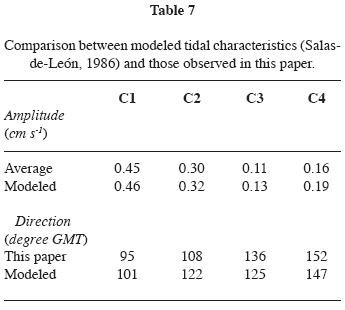
Currents in the Bay of Campeche follow the bathymetry. The M2 tidal component from the southern Gulf of Mexico enters by the Yucatan Channel turns westward at the amphidromic point near Progreso, and flows toward the Bay of Campeche by Arcas Key (Figure 2). Low amplitudes were observed near Coatzacoalcos while, the highest tides were found at Arcas Key and near Isla Del Carmen. The obtained magnitude and direction of tidal currents for the points corresponding to the anchorages (Salas–de–León, 1986), were as follows: C1, 0.41 cm s–1 and 101°; C2, 0.32 cm s–1 and 122°; C3, 0.09 cm s–1 and 125°; and C4, 0.04 cm s–1 and 147°. There is no further information on tidal currents in the Bay of Campeche.
In this study we present a tidal current analysis for the region. Results on sub–inertial frequencies will be published separately. Our data were collected over a three month period, and include coastal circulation relative to tides, wind data, atmospheric pressure and non–local forcing. Results from this study are expected to improve coastal management procedures for the region and provide information for emergency situations in case of oil spills.
Methods
A total of ten RCM4 and RCM7 Aanderaa current meters were deployed from March 1997 to May 1997 at four mooring sites (Figure 1 and Table 1). The current meters record velocity, temperature, conductivity, and water pressure; temperature, conductivity, and water pressure data were not used in this analysis. The positions of the moored current meters were obtained from the GPS navigation system aboard the R/V "Justo Sierra" of the Universidad Nacional Autónoma de México (Table 1). Calibration of the instruments and data quality analysis were performed by V. G. Koutitonsky at the University of Québec, in Rimouski, Canada.

Two or three current meters were moored at different depths (Table 2). Sampling interval was 20 minutes. Hourly time series were filtered with a Godin–type low–pass filter A24A5 (Emery and Thompson, 1998). Frequencies higher than 1.38 x 10⁻⁴ s–1, equivalent to a 2 h period, were removed. The filter does not produce phase lags (Salas–Monreal, 2006).
Tidal ellipse parameters and Greenwich phase lags were calculated via a least squares fit coupled with nodal modulations. This analysis was carried out only for constituents that could be resolved over the length of the record (e.g., Godin, 1972; Godin, 1976; Foreman, 1996). Constituent P1 and K2 were inferred from K1 and S2, respectively.
Results and discussion
Main tidal current constituents were calculated for each station and depth (Tables 3 to 6). Major (a+ + a–) and minor (a+– a–) ellipses, angles of inclination (θ) with positive x axis (Figure 3), phases (g) relative to Greenwich and constant phase angles (g+ and g–) for each constituent were reported as in Godin (1972). Unfortunately, current meter C2B proved to be unusable.

Tidal constituent K1 was dominant for nearly all surface tidal currents, down to mid water depths. However, at station 4 the main constituent of the surface tidal current was OO1. Near the bottom, the dominant constituent varied from one position to another. At station 1 the dominant component was O2, while at station 3 it was 2Q1 and at station 4 the Q1 constituent.
The period of oscillation of tidal currents was approximately 24 h. Thus diurnal tidal components were dominant, and modulated the observed tidal current configuration. The semidiurnal components showed low amplitudes at all stations. Sense of rotation of the ellipses varied from north to south. At station 1 the sense of rotation was counterclockwise, while at stations 3 and 4 it was clockwise, in agreement with Salas–de–León (1986) using a depth–integrated numerical model. Present results show a small region of negative rotation southwestward of Arcas Kay, elsewhere in the Bay of Campeche the sense of rotation was positive. The transition was located at station 2 where the upper current meter showed counterclockwise rotation, while the mid–water one showed a clockwise rotation, probably because of the Arcas Kay umbra.
The results (Table 7) agree with the modeled amplitudes and directions by Salas–de–León (1986). The modeled amplitudes were slightly higher than those observed, but the difference was less than 15 %. Angles of tidal ellipses as found from the model were higher than observed in the eastern part of the bay (C1, C2). The opposite was true in the western part of the bay (C3, C4). Differences in the angle of the tidal ellipses between those reported in this study and those obtained with the model were less than 11%.
Tidal waves affect currents in different ways with depth as the waves travel at different speeds depending on bathymetry, density differences, and bottom friction. These differences generated vertical phase lag as observed in this study. Amplitude differences from surface to bottom were 0.1 cm s–1 at stations 1 and 2 and 0.7 cm s–1 at stations 3 and 4. Phase differences from surface to bottom were 30 minutes at stations 1 and 2; 9 minutes at station 3; and 1 h at station 4. The differences in amplitude within the water column are small, but however, the differences in phase at stations 1, 2, and 4 were significant. Near the shelf breaks tidal currents can go up or down, producing a hydraulic jump to compensate for the phase lag by conservation of vorticity. This feature could also modulate the vertical displacement of plankton. Recent observations of vertically stratified sampling of zooplankton and acoustic Doppler current profilers (ADCP) showed similar patterns in the shelf break of the Bay of Campeche (Monreal–Gómez et al., in preparation).
Conclusions
Tidal current analysis in the southern shelf of the Bay of Campeche (Gulf of Mexico) revealed the dominance of constituent K1 in tidal currents. Differences in amplitude from surface to bottom were negligible but there was a vertical phase lag of up to 1 hour in the south–westernmost station. The sense of rotation of the tidal ellipse at station 1, near Arcas Kay, was negative but it was positive at other stations. Arcas Kay had a strong influence on tidal currents, as it's phase and the sense of rotation of the tidal ellipse varied within the water column.
Acknowledgements
This work was supported by PEMEX. We thank INRS–Océanologie, from the University of Québec, Canada, for collaboration in a joint project on coastal circulation in the shelf of the southern Bay of Campeche. This work is a contribution of the Instituto de Ciencias del Mar y Limnología, (ICML) of the Universidad Nacional Autónoma de México (UNAM). Comments on the original manuscript by C. Lomnitz and two anonymous reviewers are greatly appreciated.
Bibliography
EMERY, W. J. and R. E. THOMSON, 1998. Data analysis methods in physical oceanography. Pergamon Press, 634 pp. [ Links ]
GRACE, S. F., 1932. Oceanic tides. Mon. Not. R. Astron. Soc. Geophys. Suppl. 3, 70–83. [ Links ]
GODIN, G. G., 1972. The analysis of tides. University of Toronto Press. Toronto, Ontario, Canada, 264 pp. [ Links ]
GODIN, G. G., 1976. The reduction of current observations with the help of the admittance function. Technical note No. 14, Environment Canada, Ottawa, Canada. Marine Environmental Data Service, 13 pp. [ Links ]
FOREMAN, M. G. G., 1996. Manual for tidal currents analysis and prediction. Pacific Marine Science Report 78–6. Institute of Ocean Sciences, Patricia Bay, Victoria, B. C., Canada, 57 pp. [ Links ]
SALAS–DE–LEÓN, D. A., 1986. Modelisation de la marée M2 et de circulation residuelle dans le Golfe du Mexique, Ph.D. Thesis, 239 pp., Université de Liège, Liège Belgium. [ Links ]
SALAS–DE–LEÓN, D. A. and M. A. MONREAL–GÓMEZ, 1997. Mareas y circulación residual en el Golfo de México. In: Monografía No. 3 "Oceanografía Física en México", M.F. Lavín Peregrina, ed. Unión Geofísica Mexicana. México. 201–223 pp. [ Links ]
SALAS–MONREAL, D., 2006. Continously stratified flow dynamics over a hollow. Ph. D. Thesis, Old Dominion University, Norfolk, Virginia, USA, 111 pp. [ Links ]

