


Servicios Personalizados
Revista

Articulo
 Inglés (pdf)
 Artículo en XML
 Referencias del artículo
 Enviar artículo por email
Indicadores
 Citado por SciELO
 Links relacionados
-
 Similares en
SciELO
Similares en
SciELO
Compartir

 Permalink
Geofísica internacional
versión On-line ISSN 2954-436Xversión impresa ISSN 0016-7169
Geofís. Intl vol.45 no.2 Ciudad de México abr./jun. 2006
Late Pleistocene to Holocene environmental changes from δ13C determinations in soils at Teotihuacan, Mexico
E. Lounejeva Baturina1, P. Morales Puente1, H. V. Cabadas Báez2, E. Cienfuegos Alvarado1, S. Sedov1, E. Vallejo Gómez1 and E. Solleiro Rebolledo1
1 Instituto de Geología, UNAM, Ciudad Universitaria, Apartado Postal 70–296, 04510 México, D.F., México
2 Posgrado en Ciencias de la Tierra, UNAM, Ciudad Universitaria, 04510 México, D.F., México
Email: Elena Lounejeva elenal@servidor.unam.mx
Received: February 18, 2005
Accepted: May 2, 2006
Resumen
Utilizamos la firma de isótopos estables de carbono, medida como δ13C, en la materia orgánica de suelo (SOM) como un método de alta resolución espacial para inferir algunos cambios ambientales durante el Pleistoceno tardío y el Holoceno en el valle de Teotihuacan. La interpretación se basa en la diferencia de δ13Cy preferencias climáticas correspondientes de las plantas referidas como C3, C4 y CAM.
Los valores de δ13Cobtenidos de plantas que crecen en el valle hoy en día difieren claramente entre dos grupos: los de las plantas C3 con un promedio de –27%o, y los de C4 y CAM con un promedio cerca de –13%o. Los datos obtenidos para los suelos se encuentran en el intervalo de –25.72 a –15.54 %o. Las secuencias de suelos Pleistoceno tardío– Reciente del valle alto (posición geomorfológica alta), localizadas en el perfil de Cerro Gordo, se caracterizan por una δ13Ccon poca variabilidad alrededor de –20%o, indicando una coexistencia duradera entre las plantas C3 y C4 (y CAM). Las firmas más empobrecidas (–23 ± 2) %o, dominadas por carbono derivado de la vegetación tipo C3, corresponden a los suelos de pantano del Pleistoceno tardío en el perfil retrógrado de transición Tepexpan del antiguo lago de Texcoco–Xaltocan. Los paleosuelos en el valle bajo (Pleistoceno tardío – Holoceno medio), incluyendo los de la Pirámide de la Luna, están menos empobrecidos (–17 ± 1) %o, o bien, dominados por carbono de plantas C4 y CAM. Los suelos del Holoceno tardío y modernos presentan una disminución (1–2 %o) respecto a las δ13Cde los suelos subyacentes.
A partir de las δ13Cde suelos se estimó la porción relativa de la contribución de las plantas C4 a la materia orgánica del mismo. Nuestros resultados implican un incremento, dependiendo del lugar, de entre 10 y 70%, durante el período de transición entre el Pleistoceno tardío y Holoceno temprano, y un dominio de la vegetación tipo C4 en el ambiente del valle, hasta en un 84%, durante Holoceno medio. Nuestros datos apoyan la idea de un cambio natural de un clima más frío y húmedo durante el último Máximo Glacial y el Pleistoceno tardío a uno más seco y caluroso en el Holoceno medio. Un ligero incremento de humedad y establecimiento de un clima semejante al actual, aún cálido y seco, se infiere del incremento en todo el valle, dependiendo del lugar, de 4 a 10%, de la población de plantas C3. Sugerimos que este último cambio climático pudo favorecer el desarrollo de la antigua agricultura. Nuestra interpretación general de los primeros datos de isótopos estables del carbono concuerda con interpretaciones paleoambientales para el área basadas en registros palinológicos y paleolimnológicos en sedimentos lacustres.
Palabras clave: Teotihuacan, isótopos estables del carbono, paleosuelos, cambios climáticos de Cuaternario, México Central, registros arqueológicos.
Abstract
Stable carbon isotopic signature (δ13C) of soil organic matter (SOM) is used as a high–spatial resolution tool to infer environmental changes during late Pleistocene to Present in the Teotihuacan valley, Mexico. Interpretation was based on climatic preferences of C3, CAM and C4 plant groups. δ13Cvalues of modern plant types are clearly distinguished. C3 plants display values around –27%o, while C4 and CAM plants have values around—13%o. Data from soil profiles range from –25.7 to –15.5 %o. Cerro Gordo site δ13Cvaryies around –20%o, indicating long–term, time–stable co–existence between C3 and C4 or CAM plants. The more depleted signatures (–23 ± 2 %o) are, dominated by carbon from C3 vegetation of late Pleistocene swamp paleosols in the Tepexpan profile of the Lake Texcoco. Younger paleosols from lower valley sites, have less depleted values (–17 ± 1) %o, dominated by C4 and CAM carbon. Late Holocene and modern soils present slightly more negative values (1–2 %o) with respect to δ13Cof underlying soils. Our results show 1) an increase of 10–70 % depending on the site, during the transition from the late Pleistocene to early Holocene, and 2) a dominance of C4 vegetation, up to 84%, in valley environment during the middle Holocene. These data support a climatic change from cold and wet conditions in the Last Glacial Maximum and late Pleistocene, to warm and dry conditions in middle Holocene. A slight rise in moisture availability during late Holocene is inferred based on the 4–10% increase in C3 plant carbon in soils from the valley. Conditions remained generally warm and dry, much as they are at present, favouring the development of agriculture in the valley. Our interpretation agrees with results of paleoenvironmental studies at Texcoco Lake based on diatom and pollen analyses in lake.
Key words: Teotihuacan, carbon stable isotope, paleosols, Quaternary climatic changes, Central Mexico, archeological records.
Introduction
Paleoenvironmental research, in conjunction with archeological investigation, can be used to explore how landscape dynamics influenced the evolution of early human societies. Pre–Hispanic cultures in America were strongly affected by climate change. The Teotihuacan culture, one of the great civilizations of the Classic period in Mesoamerica, established a theocratic empire over an extensive territory in the Mexico and Puebla basins. They built a city that covered up to 20 km2 and supported  200 000 inhabitants. They developed stable agriculture and an efficient market for obsidian and ceramics (Millón, 1967). The causes of the decline and abandonment of the urban area around 650 AC, are still debated. Political and religious disturbances (Sanders et al., 1979) and ecological causes have been invoked. Increased aridity may have affected all of Mexico during the Classic period, along with human –induced deforestation and enhanced soil erosion; such climate changes may have contributed to agricultural degradation for Classic Mesoamerican cultures (Heine, 1987; Pérez, 2003).
Metcalfe et al. (2000) reviewed the paleoenvironmental records for the late Pleistocene – Holocene, including lacustrine palynological, diatom and sediment chemistry data, as well as glacial and stable isotope records from lacustrine ostracodes. They used mass spectrometry (AMS) 14C and glacial dating, and proposed some general tendencies as follows: 1) During the late Pleistocene (24–11 kyr BP), a generally cool climate was associated with a varying moisture availability, 2) It turned colder and drier at the end of the glacial period, a time characterized by numerous volcanic eruptions in the area, 3) In early Holocene, climate became warmer and drier marked by regional enhancement of aridity between 6000 and 5000 BP, and around 1000 yr BP. Reasons for the paleoenvironmental fluctuations have been considered by Bradbury (1989), Lozano–García et al. (1993), Urrutia–Fucugauchi et al. (1994, 1995), Caballero–Miranda et al. (1999, 2002). They suggest several causal factors, including global solar insolation shifts, regional glacial melting, tectonic and volcanic activity, as well as anthropogenic activity since middle Holocene.
Lacustrine sediments do not represent records with high spatial resolution. Paleosols provide good paleoecological–records, allowing good resolution paleoenvironment reconstruction because soil pedogenesis is controlled by a set of local soil forming factors, such as climate, humidity and biota (Targulian and Goriachnikov, 2004). Tephra and paleosol sequences from the Trans–Mexican Volcanic Belt have been used successfully for Quaternary paleoenvironmental reconstructions (Sedov et al., 2001; Sedov et al., 2003a; Solleiro et al., 2003 a, b). A frequently used "soil memory" variable is carbon isotope composition (δ13C) of soil organic matter (SOM), because carbon is an important element to understand the earth–atmosphere–biosphere system and provides insight into vegetation–environment interactions. The stable carbon isotope ratio (13C/12C) in paleosols contains information regarding the relative abundance of plant species with different photosynthetic pathways. The stable carbon isotope ratio is expressed as δ13C, the deviation of the sample isotopic signature from a standard in parts per thousand (permil).
Around 85 % of plant species generate molecules containing three atoms of carbon during Calvin–type photosynthesis (Boutton, 1991; O'Leary, 1988). These C3 plants are dominant and ubiquitous, and include tall trees, shrubs, a few grasses and some cultivated taxa such as wheat, barley, potato, bean, or cotton. They are associated with humid climate. During photosynthesis, C3 plants display a preference for the light carbon isotope (12C) in atmospheric CO2 over the heavy one (13C), and the resultant plant material is characterized by relatively low δ13Cvalues in the range from –35 to –22 %o, with a mean of –27%o (Smith and Epstein, 1971).
Another group of plants, refereed to as C4 plants, appeared at the end of the Mesozoic era (20 Ma). They are highly efficient at assembling four–carbon chains from atmospheric CO2 using the Hatch–Slack photosynthetic process. These plants represent about 5% of known modern species. They belong to eighteen families and are confined to certain geographic areas. About half of the C4 plants are tropical or sub–tropical, and around 17% of the global landscape is covered by C4 plants. They are responsible for 20–30% of terrestrial photosynthesis (Boutton, 1996). The geographic distribution and productivity of C4 plants can be correlated with high temperatures and, to a lesser extent, low humidity. These plants discriminate less against the heavy carbon isotope, and are thus characterized by higher δ13Cvalues, varying from –19 to –9%o, with a mean of –13%o (O'Leary, 1988; Boutton, 1991). They are generally associated with warm, dry climate. Many grasses, sedges and herbs, as well as maize, millet, pearl and sugar cane are examples of C4 plants. A species of shrub, found in Hawaii, is also a C4 plant (Boutton et al., 1996).
Finally, the CAM plants, use both photosynthetic mechanisms to incorporate CO2. They are known as succulents (cactus, agave, pineapple, etc.) and they represent around 10 % of plant species. At least 30 families of plants belong to this group (Koch, 1998). The CAM plants can have δ13Cvalues ranging from –28 to –10 %o depending on the particular species, but they are minor components of most ecosystems.
The main influence on δ13Cvalues in the SOM is the relative contribution from C3 versus C4 plants. Changes in the C3 versus C4 ratio in time may be attributed to changes in climate or other environmental disturbances.
Studies in C3 (Faquhar et al., 1989; Ehleringer et al., 1993) and C4 plant species (Peisker and Henderson, 1992) show that δ13Cvalues, even for sensitive C3 plants, change only about l%o in response to major variations in environmental and biological factors such as light, water supply and salinity, osmosis stress, nutrient levels, temperature and atmospheric carbon dioxide pressure, and less than 2 %o due to decomposition. On the average, δ13C of C4 plants is about 14 %o higher than δ13Cof C3 plants. This natural isotopic difference allows one to estimate the relative amount of carbon derived from each photosynthetic pathway that makes its way into the SOM pool, and to infer vegetation changes at a specific site through evaluation of the relative C3–C4 abundance. SOM can be preserved in paleosols for thousands of years enabling the use of carbon stable isotopes as a paleoecological proxy (Heine, 1987).
Earlier attempts to reconstruct paleoenvironment in the Teotihuacan valley were based on paleopedological records (McClung et al., 2003; Gama–Castro et al., 2004). The objective of the present work is to document paleoenviron–mental changes in the Teotihuacan valley using carbon stable isotope composition of organic matter in paleosols.
Site location
The Teotihuacan valley is located in the central plateau of the Trans Mexican Volcanic Belt, N19°35'–19°48', W98°45–98°58' (Figure 1). The Miocene–Plio–Pleistocene volcanoes of Cerro Gordo to the north, and Patlachique to the south, limit the valley. To the east there are small cinder cones and the Apan plains. The Valley is connected to the Mexico Basin to the southwest. Alluvial deposits cover the moust of the valley (Vásquez and Jaimes, 1989).
A stratigraphic study registered 80 m of lacustrine clays and sands alternating with tephra deposits corresponding to the last 170 kyr BP (Mooser et al., 1996).
The altitude of the valley floor is around 2200 m a.s.l. Mean annual temperature lies between 12° and 18 °C, and annual precipitation ranges between 500 and 600 mm, with highest rainfall typically in July. Higher elevation sites can receive up to 1200 mm per year (García, 1968).
Natural modern vegetation includes xerophytic scrub and evergreen oak forest (Quercus, Juniperus, Pinus), Buddleia and Schinus tree species, land grasses, aquatic and anthropogenic vegetation, i.e., barley, corn (Zea mays), tuna (Opuntia), agave and alfalfa (Rzedowski, 1957; Castilla y Tejero, 1983).
Site description
Sampling at Teotihuacan Valley (Figure 1) included sites at different altitudes: the tops of volcanic cones (Cerro Gordo), Patlachique volcano foot hills (Maseca), the border of the ancient Texcoco – Xaltocan Lake (Tepexpan); floodplain valley (Otumba) whit clear evidence of human activity; and finally the archeological site Pyramid of the Moon, belonging to Teotihuacan culture.
Cabadas–Báez (2004) and Solleiro et al. (in press) described paleopedological features, such as micromorphology, clay mineralogy and phytolits for the paleosols from Cerro Gordo, Otumba and Maseca profiles (Figure 2). Here we only summarize the main units and their relative ages. Only humus rich A and AB horizons were sampled for the isotopic study.
The Cerro Gordo soil profile is located at 2948 m a.s.l. It is composed of Luvisols at the base and a superficial Cambisol. The conventional radiocarbon date from humus of the buried 2Ah horizon is 13 340 ± 300 kyr BP which we interpreted as a minimal age of the Luvisol (Solleiro et al., in press). McClung et al. (2005) obtained 14C ages of 18 and 22 kyr BP for 2Bt and 3 Bt horizons, respectively, from a correlative profile. We conclude that the buried Luvisol pedocomplex was formed during late Pleistocene and the surface Cambisol during Holocene.
The Maseca profile presents a well–developed Stagnic Luvisol, correlative to the buried Pleistocene Luvisol of Cerro Gordo. This paleosol is overlain by a modern soil with a superficial A horizon sampled for the study because of its relative humus richness.
At the Otumba site we found a young profile of a Mollic Fluvisol of alluvial origin. The sequence contains artefacts of human activity, such as ceramic fragments and obsidian tools. The formation age 3 kyr BP (late Holocene) was attributed to the second humus rich (2A) horizon (Cabadas–Báez, 2004) as an age of the early settlements in the valley (Sanders et al., 1979).
The Tepexpan site at the southwestern exit of the Teotihuacan valley is related to the ancient Texcoco–Xaltocan lake, which was drained beginning in 1608 AD. We consider the Tepexpan profile shown in Figure 3 as a lake – dry land transitional sequence. The lowest part was deposited in the lakebed and consists of volcanic material, poor in organic matter. This lacustrine deposit is overlain by a sequence of swamp syn–sedimentary soils, and seems to be a wetland soil formed at the periphery of the retreating lake. Over this intermediate unit there are three well–developed dry–land paleosols separated by tephras. The organic matter from the depth interval of 115–130 cm dated by 14C AMS gives a minimal age for the first dry–land soil formation 4Ah of about 5.5 kyr BP (Solleiro et al., in press). The last dry–land paleosol as well as the upper part of the sequence, i.e. the modern soil, were studied at a distance about 20 m from the main profile.
The final site is just inside the gallery, dug recently for archeological research, in the Pyramid of the Moon, one of two main Teotihuacan pyramids in the central part of the valley. The wall cuts, in different parts of the pyramid, display interfaces between at least seven constructions built one on the top of the other at different times between 1800 and 1500 years ago (100–450 A.C.) (Sugiyama and Cabrera, 2003). The interface fill has a stratified structure, and is similar to the fill material between stones of the construction. It seems to be a redeposited soil rich in organic matter (Figure 4 a, b). We assume that each fill represents a surface A–horizon from the surrounding ground and consequently its carbon isotopic composition should reflect the vegetation in Teotihuacan at the time of its construction. We sampled humus–rich material from the fills of the superimposed buildings, i.e., the 2nd and 4th ones as classified by archeologists.
To establish a correlation between the isotopic signature of SOM in paleosols and modern vegetation, we sampled living plants including trees, cactus, herbs, grasses, and cultivated maize at the Otumba site. This set of samples represents the modern and more typical species of the valley that flower during the rainy season (August). Additionally, some shallow aquatic species were sampled in the area to measure the isotopic signature of swamp plants.
Methods
Soil samples were ground and sieved through a 2 mm mesh. Large bits of detritus (roots, leaves) were picked from the matrix by hand. We used 3N HCl to remove carbonates. Fine detritus was isolated after rinsing in distilled water by double centrifugation (6000 rpm, 5 min). Modern plant samples, namely leaves of trees, cactus, and maize, unsorted green and dried herbs, grasses, and aquatic species, were cleaned and washed with distilled water, dried at 75 °C for 48 h, and ground and sieved through 0.5 mm mesh before analysis. The analyses of the carbonate–free fraction for Total Soil Organic Matter (SOM, %) (Walkley and Black, 1935) allowed us calculate the total organic carbon (TOC,%) using coefficient (ref).
We used a routine combustion method (Sofer, 1980; Mook and Longsma, 1987) to prepare the samples, and a triple collector mass spectrometer (Finnigan MAT250) to analyze the δ13Cratios of the SOM (see Sedov et al., 2003b). Each batch of samples was accompanied by reference materials 8540 PEF–1 (polyethylene foil), 8539 NBS–22 (oil) and 8242 Sucrose ANU (sucrose) from NIST.
The δ13Cis expressed as δ13C= 1000 * (13C/12C sample/ 13C/12C VPDB)–1 in permil, where 13C/12C VPDB corresponds to the Cretaceous mollusk carbonate shell, Beleminitella americana, from the Pee Dee Formation in South Carolina (Craig, 1957) as accepted by the IAEA in Vienna (Coplen, 1995). The uncertainty for the analytical method is about 0.1 %o.
The proportion of carbon from C4 plants in soil samples was estimated using the mass balance equation (Boutton, 1996):
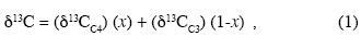
where

(x) and (1–x) represent the proportion in SOM of carbon derived from C4 (and/or CAM) species and from C3 species, respectively, δ13Cis the isotopic ratio of the sample, δ13CC4 and δ13CC3 are the respective means of the present day C4+CAM and C3 plant species in the area. Equation (2) shows a positive correlation between δ13Cof SOM and the proportion of organic carbon derived from C4 plants.
Results
The δ13Cvalues of modern vegetation and SOM, as well as the calculated fraction of C4–derived SOM, are presented in Tables 1 and 2, respectively. Data from Table 2 are plotted in Figure 5 using relative ages on the vertical axis.
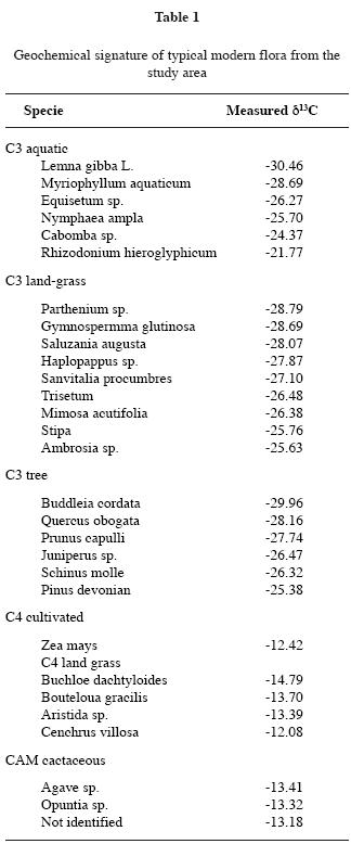
Modern vegetation. Common modern plants from the area display two ranges of δ13Cvalues: below –21 %o for C3 plants (including tall trees, aquatic, most terrestrial grasses), and above –14 %o for a small set of C4 plants (some land grass spp and maize) and CAM (cactus) plants. The calculated means for the C3 plants (–26.96 ± 1.97 %o, n=21) such as tall trees, aquatic spp. and composed (compuestas) grasses, and C4 + CAM plants (–13.29 ± 0.82 %o, n=8), are close to characteristic values reported by others (Boutton, 1991; O'Leary, 1988). Field observations show that C3, C4 and CAM species coexist in the valley.
Soils. The δ13Cresults obtained for modern soil samples from the Teotihuacan valley vary among sites by up to 4 %o, confirming the high spatial resolution that can be achieved with isotopic measurements in soils. The difference observed between time–separated samples is >2 %o and cannot be explained by post –formation factors, but instead reflects the primary vegetation buried in the soil. For each soil sample, we estimated the relative proportion (%) of carbon derived from C4+CAM plants.
The late Pleistocene–Recent soil sequence from the high–elevation Cerro Gordo profile displays intermediate δ13C values (δ13C= –20.30 ± 0.63 %o, n=4). A small maximum at –19.5%o is observed for the AB soil horizon, with estimated middle Holocene age. Along the profile, the C4 carbon contribution fluctuates from 44 to 55 % (Table 2).
The Maseca modern and cultivated soil samples have a nearly identical intermediate δ13Cvalue of –20.5 %o, comprising a mixture close to 1:1 of C3 and C4 + CAM plants. This calculated date is in good agreement with qualitative field observations of the growing plants, such as maiz and C3 species of herbs.
The main changes through time are observed in the Tepexpan profile from ancient lake Texcoco. More depleted signatures (δ13C=–23.28 ± 2.12%o, n=3), dominated by carbon derived from C3 vegetation, were measured on the late Pleistocene swamp paleosols. The minimum at –25.72 %o [9% C4] sometime in the late Pleistocene–early Holocene paleosols is followed by abrupt increases reaching –15.54 %o [84% C4] in the 2nd dry–land paleosol, tentatively assigned to the late Holocene. The late Holocene and modern soils in Tepexpan yield values of about –16.3 %o, [78% C4].
The late Holocene soil sequence from Otumba is also slightly less depleted (δ13C =–17.71 ± 0.77 %o, n=4) than modern deposits. There is a small decrease in δ13Cfrom the paleo unit (–17.1 %o, [73% C4]) to the modern one (–18.3 %o, [61% C4]).
The isotopic signature of fills from the Pirámide de la Luna is slightly higher (δ13C = – 16.60 ± 0.65 %o, n=4) than the value from modern soils from Otumba, but the youngest humus–rich horizon displays a decline (down to –17.57 %o). The corresponding C4 contribution to the soil changes from 79 to 69 % (Table 2).
Using the relative chronology, based on a mixture of carbon dating, pedological and archeological correlations, one can note a general increase in the carbon isotopic signature of paleosols between the late Pleistocene and middle Holocene, followed by a decrease in recent SOM.
Discussion
Changes in paleovegetation at the Teotihuacan valley (late Pleistocene – Present) were inferred from stable carbon isotope signatures in SOM. Environmental fluctuations in the Teotihuacan valley were reconstructed based on inferred shifts in C3/C4 plant ratios from several soil sequences. We compare our data with other paleoenvironmental proxies on local and regional scales.
Vegetation changes in Teotihuacan valley
The Cerro Gordo profile represents the vegetation at high elevations. Pollen records from the late Pleistocene –Holocene Texcoco lake sediments (Lozano–García and Ortega–Guerrero, 1998) indicate persistent and dominant (up to 90 %) arboreal pollen. Historical records from the volcano flanks suggest that C3 forest vegetation – pine, oak, cedar –that covered the volcano slopes was exploited, though some remains of oak forest still persist. Because δ13Cvalues for C3 tree species are below –25%o, differing only 1 to 2 %o from species of mesic low–lying, and drier upland landscapes (Garten and Taylor, 1992), more depleted δ13C values might be expected, at least for the modern Cerro Gordo soils. The measured signature, around –20 %o, suggests a combination of C3 and C4 plants, with almost the same proportion of each, rather than a pure tall tree (i.e., C3) community. The data gap between paleosols with estimated ages of 13 and 5 ky, limits our ability to identify precisely the time frame for the balanced coexistence of the two vegetation types. It seems that environmental changes are more perceptible in the low flood plain, and did not seriously affect the slightly cooler and moister highlands of the valley. The low variation of δ13Cthrough time at the high–elevation Cerro Gordo site contrasts with the marked temporal changes observed in the isotope record from the lowland valley profile of Tepexpan.
Vegetation changes in Teotihuacan in time: general tendencies
Late Pleistocene. Depleted δ13Cvalues from the Pleistocene paleosols, present in the Cerro Gordo and Tepexpan profiles, suggest that plants with the C3 photosynthetic pathway dominated the vegetation in the Teotihuacan valley through the late Pleistocene. We suppose that the main contributors to these paleosols were probably some tall trees on the top of Cerro Gordo, and aquatic together with near shore vegetation in the Tepexpan swamp soils, because of their low δ13Cdata at present. In general, the dominance of C3 plants through late Pleistocene, the presence of swamps reveals relatively high moisture, enough to preserve the swamps, and favors the idea of a wet and cool environment. In the particular case of intermediate swamps, where the calculated percentage of C3 plants is so high as 91%, is in agreement with an episode of moderate increase in effective moisture around 18 kyr BP interpreted from diatom records in the lower and central Lake Texcoco basin (Bradbury, 1989).
The paleopedological record from the Tepexpan profile shows evidence of gradual drying of the swamps through the Pleistocene–Holocene transition. The latest swamp soil, assigned to terminal Pleistocene, is poorer, but still rich, in C3 plants [63%], marking a transition period from a cooler to warmer but still wet climate. Brown (1985) proposed a similar climatic fluctuation around 12.5 kyr, based on the palynological records from the lake Texcoco sediments (González–Quintero and Fuentes–Mata, 1980).
Other late Pleistocene palynological records from Texcoco lake sediments (Lozano–García and Ortega–Guerrero, 1998) indicate abundant arboreal pollen that correlates with the depleted signatures of the coeval SOM dominated by C3 plant vegetation. But a drastic reduction in pine and an increase in herbaceous pollen were registered in sediments around 23 kyr old. This was interpreted as an increase in aridity that persisted to the middle Holocene.
This comparison between pollen and isotope records illustrates that inferences may differ between proxies measured in a paleosol (formed in situ) and the pollen record from a lake sediment core (a product of air and water transportation and redeposition). As pointed out by Lozano–García and Ortega–Guerrero (1998), the pollen record does not necessarily respond to climate change alone, but may be influenced, in our particular case, by volcanic activity of Popocatépetl just about 23 kyr ago (Siebe et al., 1996) and consequent changes in the hydrological system in the area.
Holocene. C4 plants dominate Holocene SOM.
The data obtained for the soils from Cerro Gordo as well as from the Tepexpan profiles indicate that in the middle Holocene the valley environment was dominated by C4 and/ or CAM species representing 55 % of the source SOM even at high elevations, and up to 84 % at sites in the lowlands. The increases of about 10 % (Cerro Gordo) and 71 % (Tepexpan) in the proportion of C4 plants in the SOM signatures may reflect increased aridity throughout the late Pleistocene and first part of the Holocene. Aridity was probably the major factor contributing to the decline in C3 plants, because of their sensitivity to water supply.
Isotopic data from all late Holocene soil samples show a modest shift in the proportion of C3 and C4 plants between the middle Holocene and the Recent. Isotope values differ from site to site, but all sites display a decrease of about 11 % in C4 and CAM representation in the Recent (Figure 5). We infer a slight increase in available moisture during late Holocene – Recent transition.
Our data suggest a general pattern of moisture availability in the Teotihuacan valley since the late Pleistocene that includes the following: 1) generally humid late Pleistocene, 2) increment of aridity through the Pleistocene –Holocene boundary culminating in middle Holocene, and 3) a return to slightly moister conditions in the recent. Climate has not changed drastically through the last 2000 years, as reflected by the carbon isotope signature in younger soils from the low valley. Furthermore, we suggest that the modest humidity increase in late Holocene may had been favorable for agricultural activity and supported irrigation, documented by archeological excavations at Teotihuacan.
Given the available isotopic data it is not yet possible to determine the time when agricultural activity became an important factor in forcing environmental change, nor can we say much about the relation between human impact and the decline of the Teotihuacan civilization.
Comparison of the environmental fluctuations in the Teotihuacan valley with surrounding areas in Central Mexico
Our interpretation of the isotopic data from paleosols and modern soils from the Teotihuacan Valley is in general agreement with paleoenvironmental studies of lacustrine sediments, and supported by some AMS radiocarbon dating, from the neighboring areas of the Central Mexico Basin.
Late Pleistocene paleosols of Nevado de Toluca, located 120 km SW of the Teotihuacan valley, present pedological evidence of cold and humid forest environments (Sedov et al., 2001), although a more detailed interpretation of the paleosol also suggests an oscillation between wet and dry periods (Sedov et al., 2003b). This last interpretation can be correlated with the episode of increased humidity reflected in the SOM of late Pleistocene swamps from the Tepexpan profile.
Relative dryness throughout the late Glacial Maximum, and very dry conditions between 14 and 4.8 kyr BP were inferred from low organic production, supported by low magnetic susceptibility and an increase in paramagnetic, weathering–derived clays in sediments from Zacapú lake, and the Lerma Basin, west of Teotihuacan (Ortega–Guerrero et al., 2002).
We propose a preliminary interpretation of δ13C data from radiocarbon–dated lacustrine sediments from Zacapú lake, western Mexico (Ortega–Guerrero et al., 2002). δ13C reported for early Holocene sediments (9.8 kyr BP) has a value of –25.7 %o, while that for the middle Holocene sediments ( 4.7 kyr BP) is –16.6 %o. These isotopic values lie in the same ranges as those obtained for the late Pleistocene swamps and Holocene soils from the Tepexpan site and suggest the same change of vegetation from C3 to C4 dominance. Although there is a discrepancy in absolute age for the two records (lacustrine versus soils) from the Zacapú and Teotihuacan sites, the same climatic trends, from wetter (and colder) to drier (and warmer), may be inferred from the two isotopic data sets.
Increasing aridity in the very late Pleistocene and early Holocene, inferred from the SOM isotopic signature at Tepexpan profile has also been inferred using the diatom and pollen records (14–8.5–6 kyr BP) from lacustrine sediments in the Central part of Texcoco lake (Bradbury, 1989) and in the upper Lerma river and Chalco lake basins (Caballero–Miranda et al., 1997, 1998, 2001, 2002; Lozano–García et al.,1993), located west and south–east, respectively, of the Teotihuacan valley.
Tecocomulco lake is located in a sub–basin NE of the Teotihuacan valley. Archaeological artifacts belonging to the Teotihuacan civilization have been found in this area (Acuña, 1984). The palynological, diatom, and magnetic records from the sediments at the southeastern part of Tecocomulco lake (Caballero–Miranda et al., 1999) indicate an extremely dry environment after ca. 16 kyr BP, until the mid–late Holocene (3 kyr BP).
Extreme aridity in Central Mexico during the middle Holocene (6 kyr BP; Metcalfe et al., 2000) can be correlated temporally with the maximum isotope values recorded in the Tepexpan (–15.54%o) and Cerro Gordo profile (–19.48%o).
The small moisture increase registered in late Holocene paleosols in Teotihuacan is consistent with an increase in water levels of the Lerma, Chalco and Texcoco lake basins, based on a diatom study of sediments younger than 5 kyr BP (Caballero–Miranda et al., 2001). Aridity around 1000 yr BP, that was inferred from the lacustrine sediment records (Metcalfe et al., 2000; Caballero–Miranda et al., 2002) cannot be inferred from the δ13Cresults from the Teotihuacan valley soils.
Numerous paleoenvironmental records suggest a change toward increased aridity in Central Mexico during the late Pleistocene. The onset of drying, however, appears to vary from site to site. The timing may be dependent on the type of record used to infer moisture availability, with some proxies displaying a lag in response to climatic drying. Climatic interpretation of any single record can be complicated by factors unrelated to climate that may potentially affect measured proxies. Correlation of different proxy records from several natural archives should be helpful for climatic interpretation.
Conclusions
Preliminary results of carbon isotopic values in paleosols and modern soils from the Teotihuacan valley suggest a 10–70% increase in C4 vegetation during the transition from late Pleistocene to early Holocene. C4 plants dominated the environment in middle Holocene. Our data suggest a natural climatic change from relatively wet and cold conditions through the late Pleistocene to warmer and very dry conditions in the middle Holocene. A slight increase in moisture availability and establishment of a relatively dry and warm climate in the late Holocene is suggested by a modest 4–10 % increase in the C3 plant community in the valley. The small increase in moisture availability may have been favourable for agriculture. This preliminary interpretation of the first isotopic data obtained from paleosols and modern soils in general agrees with paleoenvironmental studies in lake Texcoco area based on diatom and pollen records from lake sediment cores. Low temporal resolution of the isotope data from soil samples precludes inferences about climatic influence on the evolution of the Teotihuacan civilization.
Acknowledgments
UNAM PAPIIT (IN400403–2) and CONACYT (No.43746) projects financed part of this work. We acknowledge S. Palacios Mayorga and F. Ramos Marchena for appreciated help in plant sampling and identification; K. Shimada, E. Ibarra and M. Hernández Quiroga for technical assistance. Dr. E. McClung is acknowledged for advising on archeological questions, Dr. M. Caballero–Miranda for fruitful discussion, and Dr. M. Brenner for a critical review essential to the improvement of the manuscript.
Bibliography
ACUÑA, R. (Ed.), 1984. Relaciones geográficas del Siglo XVI: México, Tomo II. Instituto de Investigaciones Antropológicas, UNAM, México. [ Links ]
BRADBURY, J., 1989. Late Quaternary lacustrine paleoenvironments in the Mexico basin. Quat. Sci. Rev., 8, 75–100. [ Links ]
BROWN, R. B., 1985. A summary of late–Quaternary pollen records from Mexico west of the Isthmus of Tehuantepec. In: Bryant, V.M., jr. and Holloway, R.G. (eds.), pollen records of late–Quaternary North American Sediments, p. 71–94. American Association of Stratigraphic Palynological Foundation. [ Links ]
BOUTTON, T. W., 1991. Carbon isotope techniques. In: Coleman, D.C. and Fry, B. (Eds). Academic Press, New York. 173–185. [ Links ]
BOUTTON, T. W., 1996. Stable carbon isotope ratios of soil organic matter and their use as indicators of vegetation and climatic change. In: Boutton, T.W., Yamasaki, S. (Eds.) Mass spectrometry of soils. Marcel Dekker, Inc. , 517p. [ Links ]
CABADAS–BÁEZ, H. V., 2004. Paleosuelos como indicadores de cambio ambiental en el Cuaternario superior: el caso del valle Teotihuacan. Tesis de licenciatura, Facultad de Ingeniería, Universidad Autónoma de México, México, D.F. 167 p. [ Links ]
CABALLERO–MIRANDA, M., 1997. The Last Glacial Maximum in the basin of Mexico: The diatom record between 34,000 and 15,000 years BP from lake Chalco. Quater. Inter., 43/44, 125–136. [ Links ]
CABALLERO–MIRANDA M. and B. ORTEGA–GUERRERO, 1998. Lake levels since about 40,000 years ago at lake Chalco, near Mexico City. Quater. Res., 50, 69–79. [ Links ]
CABALLERO–MIRANDA, M., B. ORTEGA–GUERRERO, J. URRUTIA –FUCUGAUCHI and J. L. MACÍAS, 1999. Environmental characteristics of lake Tecocomulco, northern basin of Mexico, for the last ca. 50,000 years. J. Paleolimnol., 22, 399–411. [ Links ]
CABALLERO–MIRANDA, M., J. L. MACÍAS, S. LOZANO–GARCÍA, J. URRUTIA–FUCUGAUCHI and R. CASTAÑEDA–BERNAL, 2001. Late Pleistocene–Holocene volcanic stratigraphy and paleoenvironments of the upper Lerma basin, Mexico. Spec. Pubs int. Ass. Sediment, 30, 247–261. [ Links ]
CABALLERO–MIRANDA, M., B. ORTEGA–GUERRERO, F. VALADEZ, S. METCALFE, J. L. MACÍAS and Y. SUGIURA, 2002. Sta.Cruz Atizapán: a 22–ka lake level record and climatic implications for the Holocene human occupation in the Upper Lerma basin, Central Mexico. Palaeogeogr., Palaeoclimatol., Palaeoecol., 186, 217–235. [ Links ]
CASTILLA, M. E. and J. D. TEJERO, 1983. Estudio florístico del Cerro Gordo (Próximo a San Teotihuacan) y regiones aledañas. Tesis de licenciatura en Biología, Escuela Nacional de Estudios Profesionales Iztacala, UNAM, México. [ Links ]
COPLEN, T. B., 1995. Reporting of stable carbon, hydrogen, and oxygen isotopic abundances. In: Reference and intercomparison materials for stable isotopes of light elements: Vienna, International Atomic Energy Agency, IAEA–TECDOC–825, 31–34. [ Links ]
CRAIG, H., 1957. Isotopic standards for carbon and oxygen and corrected factors for mass–spectrometric analysis of carbon dioxide. Geochimica et Cosmochimica Acta, 12, 133–149. [ Links ]
EHLERINGER, J. R., A. E. HALL and G. D. FARQUHAR, 1993. Stable isotopes and plant carbon– water– relation. Academic Press, New York. [ Links ]
FARQUHAR, G. D., J. R. EHLERINGER and K. T. HUBIC, 1989. Carbon isotope discrimination and photosynthesis. Annu. Rev. Plant Physiology and Plant Mol. Biol., 40, 503–537. [ Links ]
GAMA–CASTRO, J., E. SOLLEIRO–REBOLLEDO, E. MCCLUNG, J. L. VILLALPANDO, S. SEDOV, C. JASSO–CASTAÑEDA, S. PALACIOS and D. HERNÁNDEZ, 2004. Contribuciones de la Ciencia del Suelo a la investigación arqueológica– el caso de Teotihuacan. (Terra, in press). [ Links ]
GARCÍA, E., 1968. Clima actual de Teotihuacan. In: Lorenzo, J. L. (Ed.) Materiales para la Arqueología de Teotihuacan XVII. INAH, México, 10–27. [ Links ]
GARTEN, C. T. and G. E. TAYLOR, 1992. Foliar δ13C within a temperate deciduous forest: spatial, temporal and species sources of variation. Oecologia, 90, 1–7. [ Links ]
GENOVÉS TARAZAGA, S., 1960. Revaluation of age, stature and sex of the Tepexpan remains, Mexico. Amer. J. Phys. Anthropol., 18, 205–218. [ Links ]
GONZÁLEZ–QUINTERO, L. and L. FUENTES–MATA, 1980. El Holoceno de la porción central de la Cuenca de México. In: Sánchez, F. (Ed.), Memorias III Coloquio sobre paleobotánica y Palinología. Colección Científica Instituto Nacional de Antropología e Historia, 86, 113–132. [ Links ]
HEINE, K., 1987. Anthropogenic sedimentological changes during the Holocene in Central America: Striae, 26, 51–63. [ Links ]
KOCH, L., 1998. Isotopic reconstruction of past continental environments. Annual Review of Earth and Planetary Science, 26, 573–613. [ Links ]
LOZANO–GARCÍA, S. and B. ORTEGA–GUERRERO, 1998. Late Quaternary environmental changes of the central part of the Basin of Mexico; correlation between Texcoco and Chalco basins. Review of Palaeobotany and Palynology, 99, 77–93. [ Links ]
LOZANO–GARCÍA, M. S., B. ORTEGA–GUERRERO, M. CABALLERO–MIRANDA and J. URRUTIA–FUCUGAUCHI, 1993. Late Pleistocene and Holocene paleoenvironments of Chalco Lake, central Mexico. Quatern. Res., 40, 332–342. [ Links ]
MACÍAS, J. L., S. LOZANO–GARCÍA, J. URRUTIA–FUCUGAUCHI and R. CASTAÑEDA–BERNAL, 2001. Late –Pleistocene–Holocene volcanic stratigraphy and palaeoenvironments of the Upper Lerma basin, México. Spec. Publs int. Ass Sediment. 30, 247–261. [ Links ]
McCLUNG, E., E. SOLLEIRO–REBOLLEDO, J. GAMA–CASTRO, J. L. VILLALPANDO and S. SEDOV, 2003. Paleosols in the Teotihuacan valley, Mexico: evidence for paleoenvironment and human impact. Revista Mexicana de Ciencias Geológicas, 20, 3, 270–282 [ Links ]
METCALFE, S. E., S. L. O'HARA M. and S. J. DAVIES, 2000. Records of late Pleistocene–Holocene climatic change in Mexico – a review. Quatern. Sci. Rev., 19, 699–721. [ Links ]
MILLÓN, R., 1967. Extensión y población de la ciudad de Teotihuacan en sus diferentes periodos: un cálculo provisional. Onceava Mesa Redonda de la Sociedad Mexicana de la Antropología, 57–78, México. [ Links ]
MOOK, W. G. and J. LONGSMA, 1987. Measurement of the N2O corrections for 13C/12C ratios of atmospheric CO2 by removal of N2O. Tellus, 39B, 96–99. [ Links ]
MOOSER, F., A. MONTIEL and A. ZÚÑIGA, 1996. Nuevo mapa geológico de las cuencas de México, Toluca y Puebla. Estratigrafía, tectónica regional y aspectos geotérmicos. CFE, 1937–1996, México. [ Links ]
O'LEARY, M. H., 1988. Carbon isotopes in photosynthesis. Bioscience 38, 328–336. [ Links ]
ORTEGA, B., M. CABALLERO, S. LOZANO, I. ISRADE and G. VILACLARA, 2002. 52 000 years of environmental history in Zacapú basin, Michoacán, Mexico: the magnetic record. Earth. Planet. Sci. Lett., 202, 663–675. [ Links ]
PEISKER, M. and S. A. HENDERSON, 1992. CARBON TERRESTRIAL C4 PLANTS. Plant, Cell and Environm., 15, 987–1004. [ Links ]
PÉREZ, J., 2003. La agricultura en Teotihuacan. Una forma de modificación al paisaje. Tesis de Maestra. Facultad de Filosofía y Letras, UNAM, 284 . [ Links ]
POMPA Y PADILLA, J. A. and E. SERRANO CARRETO, 2001. Los más antiguos americanos. Arqueología Mexicana IX (52), 36–41. [ Links ]
RZEDOWSKI, J., 1957. Algunas asociaciones vegetales de los terrenos del lago de Texcoco. Boletín de la Sociedad Botánica de México, 21, 1–15. [ Links ]
SANDERS, W., J. PARSONS and R. SANTLEY, 1979. The Basin of Mexico: Ecological Processes in the Evolution of a Civilization. New York, Academic Press. [ Links ]
SEDOV, S., E. SOLLEIRO–REBOLLEDO, J. E. GAMA–CASTRO, E. VALLEJO–GÓMEZ and A. GONZÁLEZ–VELÁZQUEZ, 2001. Buried paleosols of the Nevado de Toluca: an alternative record of late Quaternary environmental change in central Mexico. J. Quater. Sci., 16, 375–389. [ Links ]
SEDOV, S., E. SOLLEIRO–REBOLLEDO and J. GAMA–CASTRO, 2003a. Andosol to Luvisol evolution in central Mexico: timing, mechanisms and environmental setting. Catena, 54 (3), 495–513. [ Links ]
SEDOV, S., E. SOLLEIRO–REBOLLEDO, MORALES–PUENTE, A. ARIAS–HERRERÍA, E. VALLEJO–GÓMEZ and C. JASSO–CASTAÑEDA, 2003b. Mineral and organic components of the buried paleosols of the Nevado de Toluca/central Mexico as indicators of paleoenvironments and soil evolution. Quatern. Int., 106–107, 169–184. [ Links ]
SIEBE, C. G., M. ABRAMS, J. L. MACÍAS and J. OBENHOLZNER, 1996. Repeated volcanic disasters in Prehispanic time at Popocatépetl, Central Mexico: Past key to the future? Geology, 24, 399–402. [ Links ]
SMITH, B. N. and S. EPSTEIN, 1971. Two categories of 13C/12C ratios of higher plants. Plant physiology, 47, 380–384. [ Links ]
SOFER, Z., 1980. Preparation of carbon dioxide for stable carbon isotope analysis of petroleum fractions. Analyt. Geochem., 52, 1389–1391. [ Links ]
SUGIYAMA, S. and R. CABRERA, 2003. Hallazgos recientes en la Pirámide de la Luna. Arqueología Mexicana, XI, 64, 42–49. [ Links ]
SOLLEIRO–REBOLLEDO, E., J. L. MACÍAS, S. GAMA–CASTRO and S. SEDOV, 2003a. Quaternary pedostratigraphy of the Nevado de Toluca volcano. Rev. Mex. Ciencias Geológicas, 21 (1), 101–109. [ Links ]
SOLLEIRO–REBOLLEDO, E., S. SEDOV, J. E. GAMA–CASTRO, D. FLORES–ROMÁN and G. ESCAMILLA–SARABIA, 2003b. Paleosol–sedimentary sequences of the Glacis de Buenavista, central Mexico: interaction of late Quaternary pedogenesis and volcanic sedimentation. Quatern. Int., 106–107, 185–201. [ Links ]
TARGULIAN, V. O. and S. V. GORIACHKIN, 2004. Soil memory: Types of record, carriers, hierarchy and diversity. Rev. Mex. Ciencias Geológicas, 21( 1), 1–8. [ Links ]
URRUTIA–FUCUGAUCHI, J., M. S. LOZANO–GARCÍA, B. ORTEGA–GUERRERO and CABALLERO–MIRANDA, M., 1995. Paleomagnetic and paleoenvironmental studies in the southern basin of Mexico–II. Late Pleistocene–Holocene Chalco Lake record. Geofís. Int., 34, 33–53. [ Links ]
URRUTIA–FUCUGAUCHI, J., M. S. LOZANO–GARCÍA, B. ORTEGA–GUERRERO, M. CABALLERO–MIRANDA, R. HANSEN, H. BOEHNEL and J. F. W. NEGENDANK, 1994. Paleomagnetic and paleoenvironmental studies in the southern basin of Mexico–I. Volcanosedimentary sequence and basin structure of Chalco Lake. Geofís. Int., 33, 421–430. [ Links ]
VÁZQUEZ–SÁNCHEZ, E. R. and L. JAIMES–PALOMERA, 1989. Geología de la Cuenca de MÉXICO. Geofís. Int., 28(2), 133–190. [ Links ]

