


 texto en
  Inglés (pdf)
 Artículo en XML
 Referencias del artículo
 Enviar artículo por email
 Citado por SciELO
  Similares en
SciELO
Similares en
SciELO 
 Permalink
Introduction
The state of Michoacán has a total area of 5’893,103 ha, where 61 % (3,596,428 ha) present a forest use (forests, scrub, mesquite woodland, palm grove, jungles and mangroves) and the rest (38.8 %) is destined for temporary and irrigation agriculture, livestock, human settlements, bodies of water and material banks (COFOM, 2015).
Forest ecosystems in Michoacán present different degrees of environmental deterioration mainly due to anthropic factors, such as deforestation (28.5 %) and land use change (27.9 %). In this last one, the increase of the agricultural and livestock frontier has caused environmental imbalances, irreversible in some cases. In the year 2014, it was reported that nearly 1,138,897 ha of forest area in the state had some type of degradation, and 518,067 ha of his are assigned for livestock activities (COFOM, 2015).
The historical process of the anthropogenic activities evidences the agricultural and livestock frontier over the forestry. On the other hand, the productive alternatives are limited for the recovery of land with a forest vocation. A strategy to counteract the fragmentation and environmental deterioration of cold temperate forest ecosystems from Michoacán is the implementation of silvopastoral systems. Several studies have shown that under good management it is possible to increase the production of fodder crops such as native or introduced grasses and high quality timber (Alonso, 2011; Schroth, 1999). On the other hand, it is possible to recover forest use, reduce soil erosion, increase the capture of organic carbon and biodiversity, increase the productivity of traditional systems and improve the hydrological behavior of watersheds (Robinson, 2000; SAGARPA, 2009; Sáenz et al., 2010).
The State of Michoacán, due to its ecological, geological, physiographic and topographic characteristics, presents favorable conditions for the development of silvopastoral systems in temperate regions. These systems can incorporate components such as conifers such as Pinus devoniana Lind. found in the Red List of threatened species (Farjon, 2013) and can be associated with perennial forage crops such as introduced grasses such as Chloris gayana Kunth or Eragrostis curvula (Schard.) Nees, these can produce up to 4 times more forage than native grasses. The importance of the use of the wood of P. devoniana is destined to industry of sawmill, paper, piles, construction, cabinetry, furniture, plywood, sheet, stave, among others (Cornejo & Ibarra, 2008; Sáenz et al., 2012). These systems can be a productive alternative for the land reconversions with forest vocation and benefit for the local communities. However, in order to make the components of the silvopastoral system more efficient, it is necessary to delimit the areas with the best potential for the establishment of these species. The Geographic Information Systems (GIS) represent a tool to explain and help resolve the main problems such as deforestation and land use change. The results obtained for their implementation are basic for efficient decision making on the planning of land use for conservation, protection and/or restoration of degraded ecosystems. The Geographic Information systems have been used in studies of productive potential for the establishment of plantations in different ecosystems from arid and semi-arid, tropical and temperate forests (Meza, 2001; Meza, 2003; Sotelo et al., 2005; Chacón et al., 2010; Sáenz et al., 2010; Castillo et al., 2014, Muñoz et al., 2016a; Muñoz et al., 2016b).
The objective of this work was to determine potential areas to establish silvopastoral systems with Pinus devoniana Lind. in association and Chloris gayana Kunth or Eragrostis curvula (Schard.) Nees in temperate climate of Michoacán.
Material and Methods
Study area
The study area included regions with temperate climate (1,644,469 ha): Oriente, Centro, Meseta Purépecha and Sierra de Coalcomán, which represent 28 % of the total area (5,873,103 ha) of the state of Michoacán (Figure 1), located between 20 ° 23 ‘43’ ‘- 18 ° 09’ 47 ‘’ of Latitude North (LN) and 100 ° 04 ‘45’ ‘- 103 ° 44’ 49 ‘’ Latitude West (LO) with an extension of 59,864 km2 and represents the 2.9 % of the country, adjoins to the North with the states of Guanajuato and Jalisco, to the Northwest with Querétaro, to the East with the State of Mexico, to the Southeast with Guerrero, to the South with the Pacific Ocean, to the West with Colima and the South part of Jalisco; and is made up of 113 municipalities (INEGI, 2012; COFOM, 2015).

In Michoacán the climates are strongly distributed according to the altimetry contrasts of the relief and presents the following climatic types: A (w), warm subhumid; A (C) (m), semi-warm humid; A (C) (w), semi-warm subhumid; C (m), temperate humid; C (w) = temperate subhumid; C (E) (m), semi-cool humid; and BS1 (h), dry and semi-dry, very warm and warm, according to (García, 1981). The monthly mean temperatures fluctuate from 13 to 29 ºC; the highest temperatures occur in the regions of the Coast and Tierra Caliente, particularly in the areas with lowest altitude, where the mean annual values are near to 30 ºC, the lowest temperatures are recorded in the mountain areas; the maximum extreme temperatures range from 27 to 48 ºC and extreme minimums from -7 to 18 ºC. The precipitation varies from 600 to 1,600 mm per year (INAFED, 2013, COFOM, 2015).
Silvopastoral components
Forestry component
Pinus devoniana Lind. Pinaceae (Tropicos, 2018) commonly known as “Pino lacio,” is a native tree species from Mexico and Central America; its distribution area extends from central Guatemala to northern Mexico. In Mexico, this species has been reported in the states of Chiapas, Michoacán, Nayarit, Oaxaca, Jalisco, Zacatecas, Mexico state, Durango, Guerrero, Hidalgo, Puebla, Morelos, Nuevo Leon, Veracruz and Guanajuato. In Michoacán, P. devoniana is distributed in the Eastern, Southwestern and Central regions. These regions have an average annual precipitation between 650 to 1,600 mm, but their best station quality is between 900 to 1,200 mm and temperatures between -8 to 45 °C and an average of 17.8 ºC (Sánchez, 2008). Generally, it is located at altitudes between 1,500-2,400 masl, although its highest development reaches it between 1,800 to 2,000 masl; however, its altitudinal limits are usual between 1,075 and 3,000 m (Perry, 1992). In relation to the production of wood, increases by 3 to 10 m3 ha-1 per year are reported, so that, in a period of 20-25 years, it could be expected at least 350 m3 ha-1 (PRODEFO, 2001; SEMARNAT, 2005; Sánchez, 2008), this production is destined for the sawmill industry, paper and among others (Cornejo & Ibarra, 2008; Muñoz et al., 2012).
Forage components
1.- Eragrostis curvula (Schrad.) Nees, Poaceae (Tropicos, 2018) colloquially known as weeping lovegrass, is a perennial species introduced in Mexico, whose origin is South Africa; in Mexico, weeping lovegrass is reported in the states of Chihuahua, Coahuila, Mexico City, Durango, Guanajuato, Michoacán, Nuevo León, Querétaro, Sonora and Tlaxcala (Valdés, 2015); it is characterized for being resistant to drought, it grows mainly in spring-summer and responds quickly to rainfall after a deficiency of prolonged rain, with great potential to recover and increase forage productivity, mainly in degraded areas; It adapts easily to soils with a sandy-loam and clay-loam texture with pH between 6 and 8, with good drainage. It is estimated that it can produce up to 4 times more forage than native grasses, that is, from 2.8 to 3.5 t ha-1 of dry matter, compared to 0.8 t that can be produced by a pasture of Bouteloua gracilis (Kunth) Lag. ex Steud in good condition. In terms of forage value, the crude protein content is up to 15 % in the spring-summer cycle, although it decreases to less than 5 % in winter (Esqueda & Carrillo, 2012; CONABIO, 2017).
2.- Chloris gayana Kunth. Poaceae (Tropicos, 2018) which is commonly known as Rhodes grass, is an introduced grass, native from Africa, there are distribution records in North, Central and South America, including the Caribbean. In Mexico, it is distributed in 22 states including Michoacán. This species is distributed in a wide range of climates ranging from subtropical to temperate, as well as light to heavy soils, at altitudes between 1,000 to 2,200 masl, average annual temperature of 18 to 25 ºC and annual rainfall of 500 to 1,500 mm. However, it can grow in areas with annual rainfalls between 600 and 850 mm (Medina et al., 2001; Velázquez et al., 2001; Oprandi et al., 2009; Vibrans, 2009). C. gayana is a grass that allows direct grazing and in addition, can be reserve in the winter and/or stored as good quality hay when the cut is made prior to flowering. This species is an alternative for forage production in rainfed crops, in the soils rehabilitation due its favors the formation of aggregates and increases the content of organic matter in tepetates soil (Velázquez et al., 2001). In Michoacán, dry matter yields between 5 and 15-ton ha-1 are reported (Jiménez, 2001).
Determination of potential areas
The research was developed in the years 2012 and 2013 for the determination of potential areas for the establishment of silvopastoral systems in the temperate climate of Michoacán. The variables and ranges of forest component (Pinus devoniana Lind.) and the forage component (Chloris gayana Kunth. or Eragrostis curvula (Schrad.) Nees) was defined based on the literature search of the agroecological requirements of the two components (Medina et al., 2001; Velázquez et al., 2001; Aguilar et al., 2005; SEMARNAP, 2006; Sánchez, 2008; Oprandi et al., 2009; Vibrans, 2009; Sáenz et al., 2010; Debreczy et al., 2011), these were: altitude, precipitation, temperature, type of soil and slope (Table 1).
Table 1 Agroecological requirements to determine the potential areas of silvopastoral system components in the state of Michoacan, Mexico.
| Forest component | Forage Component | Altitude (masl) | Precipitation (mm) | Annual Media Temperature (ºC) | Soil Class | Slope (%) |
|---|---|---|---|---|---|---|
| Pinus devoniana | Chloris gayana o Eragrostis curvula | 1,500-2,400 | 800-1,500 | 12-21 | Andosol and Luvisol | 10-20 |
In the determination of the potential areas for the silvopastoral system with P. devoniana and C. gayana or E. curvula, the program IDRISI 32 ver. 2.0 (Eastman, 1999) was used, which is a software that works with Geographic Information Systems (GIS), as well as the digital cartographic and climatic information generated by the National Institute of Agricultural and Livestock Forestry Research (INIFAP).
The RECLASS command was used for reclassifying the altitude, precipitation, average annual temperature, slope and soil type maps from the state of Michoacán, the areas that did not meet the characteristics required for the species were discarded but not those that did. To this end, a stratification system of the potential areas was designed, which was based on the following categories or levels of aptitude: Not suitable = 0, includes areas that do not have optimal conditions for the development and growth of the species under study, and areas apt = 1, includes the areas that guarantee the adaptation of the species, by presenting favorable conditions for its development. These covers individually contain the interval of each variable associated with the distribution of the species under study. The images obtained were superimposed by the OVERLAY command, thus obtaining the potential areas for the species. Through the AREA command, the surface of these areas was calculated. Once the images of the potential areas were obtained in RASTER format with the (GIS) IDRISI 32, the REFORMAT command was used to convert the image to vector, later each image was exported to shapefile format to work in GIS ArcView version 3.2 (ESRI, 1999) where images in 1: 100,000 and 1: 250,000 scale were obtained.
Results and Discussion
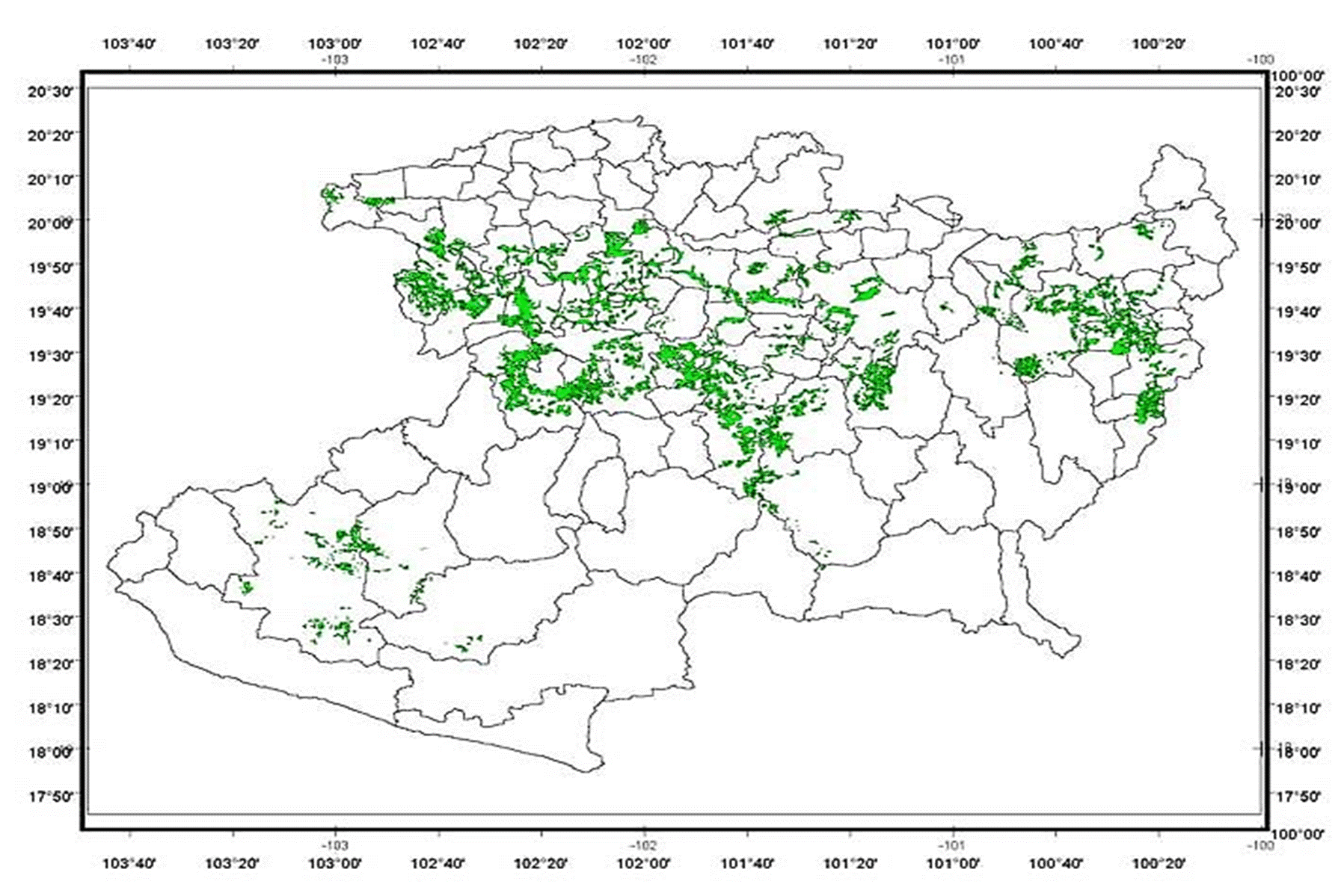
The analysis for determining the productive potential for the two components of P. devoniana and C. gayana or E. curvula for the state of Michoacán according to the methodology used and based on the agroecological requirements of altitude, precipitation, average annual temperature, type of soil, and slope of each one of the components that would integrate the silvopastoral system, indicate that for the state of Michoacán it can be implemented in a total of 226,417 ha (Table 2). This surface is susceptible for a productive reconversion due to its forestry and forage vocation, in a temperate climate in the state of Michoacan (Figure 2).
Table 2 Potential area and localities for the establishment of silvopastoral systems with Pinus devoniana Lind. and Chloris gayana (Schrad.) Nees or Eragrostis curvula Kunth. in areas of temperate climate of Michoacán, México.
| Silvopastoral systems components | Potential area (ha) | Municipalities |
|---|---|---|
| Pinus devoniana Lind. y Eragrostis curvula Kunth. o Chloris gayana (Schrad.) Nees | 226,417 | Hidalgo, Tuxpan, Zitácuaro, Salvador Escalante, Ario de Rosales, Tingambato, Uruapan, Tancítaro, Nuevo Parangaricutiro, Peribán y Los Reyes. |
Source: Own elaboration with INIFAP database.
Figure 2 Potential area for establishment of the silvopastoral system with Pinus devoniana Lind. and Eragrostis curvula Kunth. or Chloris gayana (Schrad.) Nees, in areas of temperate climate of Michoacán, Mexico.
In Figure 2, the sites with appropriate aptitude to establish the silvopastoral system Pinus devoniana Lind and Eragrostis curves Kunth. or Chloris gayana (Schrad) Nees are shown. The establishment of these systems could be used in the short term for livestock, medium and long term for the use of forest products such as firewood, andirons, cellulous and wood, including livestock grazing.
The identification of proposed potential areas with the silvopastoral system was made taking into account the agroecological characteristics of each of the species involved; so the types of andosol and luvisol soils are suitable for the development of both the forest component and the forage components, under the design of alley cropping.
Schroth (1999) states that the root systems of associated plants interact in different ways, ranging from severe competition to complementation and facilitation. Even, when competition occurs, it is not necessarily negative for root systems, since the total nutrients and water use may increase; as cited by Eastman et al. (1990) which comments, this can be positive since with an increase of tree density, the use of groundwater increased and the absorption of nutrients in a silvopastoral system in Australia may increase as well.
Based on the above and the characteristics of soil types of andosol (rich in minerals, excellent structure and high fertility) and luvisol (fertile, rich in bases and with a marked textural differentiation). In addition, the differentiation in growth of the root systems of the silvopastoral system components, where Pinus species have pivoting root, with a development between 2.30 and 3.9 m of depth, while the roots of the pastures are at a lower depth, in a range of 1.40 a 2.6 m (Canadell et al., 1996), there is the possibility of a slight competition among roots for the space and nutrients in the arboreal and grass component.
These areas with potential for the establishment of silvopastoral systems coincide with the results obtained by Sáenz et al. (2007) in the determination of potential areas for silvopastoral systems in Michoacán with Pinus pseudostrobus Lindl., Pinus michoacana var. cornuta Martínez, Pinus montezumae Gordon & Glend. and Pinus lawsonii Roezl ex Gordon with forage species in the Cuitzeo Lake Basin; also, with Chacón et al. (2010), who generated thematic maps that represent a tool for decision making in the management, use and exploitation of natural forest resources in the arid and semi-arid zones of southern Chihuahua.
This methodology (GIS) is of great importance, because it helps to identify the sites with the best capacity for establishment and development of the species, as shown by our results and other works by Sáenz et al. (2000) and Rueda et al. (2007), who used the same variables used in this research, and generated maps with potential areas for the establishment of forest plantations for Michoacán and Jalisco states using tree species from tropical and cold climate ecosystems. Likewise, this results coincide with the ones obtained by Meza (2001) and Meza (2003) who determined the potential areas for plantations of Azadirachta indica A. Juss and Turnera diffusa Willd. in Baja California Sur; and with the study conducted by Sotelo et al. (2005) who defined the areas with the environmental requirements for the cultivation of Hylocereus undatus (Haw.) Britton & Rose for the south of the State of Mexico. Similarly, with Islas et al. (2005) in the determination of the potential distribution for edible wild mushroom species such as Russula lutea (Huds.) Gray, Morchella esculenta L. Sowerby, among others, in coniferous forests of the state of Oaxaca. In addition, it constitutes the basis for the planning of programs and decision making for the establishment of silvopastoral systems in temperate climates in the state of Michoacan.
The silvopastoral systems integrated by Pinus devoniana Lind. and Eragrostis curves Kunth. or Chloris gayana (Schrad.) Nees have been established in Pátzcuaro and Cuitzeo Lake Basins, in the “El Calabozo” microbasin and the eastern region of the state of Michoacán. This places are characterized by presented a temperate climate with precipitation between 800 to 1,200 mm and a temperature of 12 to 18 ° C, soils andosol and luvisol type with slopes of 5 to 20 % and 1,800 to 2,400 meters above sea level (Sáenz et al., 2010; Sáenz et al., 2011; Sáenz et al., 2013); these systems have been established with the design of alley cropping and forest plantation with densities of 625 and 1,250 trees ha-1. For the forage component of C. gayana or E. curvula, 4 and 6 kg per ha of seed are required and a fertilization dose of 40-46-00 and 32-23-00 is applied at the time of planting and each year at the beginning of the rainy season, respectively. In both pastures, after each cut or livestock grazing, a fertilization dose of 46-00-00 should be applied. In this silvopastoral system, the use of grasses begins on average 90 days after sowing and is possible to maintain 4 to 6 cattle units/ ha / year or 40 to 60 of smaller livestock, during the period of rain, while the forest component continues in development; this animal load decreases from 2 to 3 units’ animal ha, as the trees is growing, until reaching an age greater than 10 years, due to competition for space and light (Sáenz et al., 2010; Sáenz et al., 2011).
The establishment of silvopastoral systems, will help in the productive reconversion of soils with forest aptitude, diversification of production, increase in productivity, generation of economic resources in the short and medium term by forage crops and livestock production, for the direct benefit of the inhabitants from the rural area; In addition, the prairie establishments with any of the two forage components, will contribute ecological benefits, such as: reduction of surface runoff, the increase of infiltration to the soil, and in consequence the reduction of soil erosion and the risk of flooding downstream (Park et al., 2017). In addition, the SIG constitutes the basis for the planning of programs and decision making for the establishment of silvopastoral systems in temperate climates in the state of Michoacán.
Conclusions
The potential surface for establishment of the silvopastoral system with Pinus devoniana Lind. in associated with Chloris gayana (Schrad.) Nees or Eragrostis curves Kunth. in the state of Michoacán is near 226,417 ha, and integrates in the municipalities of Hidalgo, Tuxpan, Zitácuaro, Salvador Escalante, Ario de Rosales, Tingambato, Uruapan, Tancítaro, Nuevo Parangaricutiro, Peribán and Los Reyes.
This area of 226,417 ha with capacity for silvopastoral establishment, represents 13.77 % from temperate climate areas and 43 % from area total allocated to livestock grazing in the forest areas, and 19.8 % from total forest area with problems of ambiental deterioration in Michoacán de la superficie total forestal con problemas de deterioro state. Given this consideration, it is required that new en Michoacán. Ante esta consideración, se requiere que se silvopastoral or agroforestry systems components be exploren nuevos componentes de sistemas silvopastoriles explored, in order to reconvert the more than one million o agroforestales, para reconvertir las más de un millón de hectares with problems of deterioration in this State.

