


Servicios Personalizados
Revista
Articulo
 Inglés (pdf)
 Artículo en XML
 Referencias del artículo
 Enviar artículo por email
Indicadores
-
 Citado por SciELO
 -
 Accesos
Links relacionados
-
 Similares en
SciELO
Similares en
SciELO
Compartir

 Permalink
Estudios de cultura maya
versión impresa ISSN 0185-2574
Estud. cult. maya vol.40 Ciudad de México ene. 2012
Artículos
Under the Rule of the Snake Kings: Uxul in the 7th and 8th centuries*
Nikolai Grube*, Kai Delvendahl*, Nicolaus Seefeld* and Beniamino Volta**
* Uxul Archaeological Project Universität Bonn. ngrube@uni-bonn.de / huunnah@gmail.com / nseefeld@uni-bonn.de.
** Department of Anthropology, University of California-San Diego. bvolta@ucsd.edu.
Recepción: 1 de junio del 2012.
Aceptación: 9 de julio del 2012.
Resumen
Desde el 2009, la Universidad de Bonn efectúa trabajos arqueológicos en el sitio de Uxul, una ciudad maya del Clásico en el extremo sur del estado de Campeche. El objetivo del proyecto es investigar la expansión y desintegración de los poderes hegemónicos en el área maya, con un enfoque en la zona central de las Tierras Bajas y específicamente en la estrecha relación de Uxul con los gobernantes de la poderosa dinastía Kaan de Calakmul. Evidencia novedosa confirma las hipótesis de que Uxul estuvo bajo control de Calakmul en el siglo VII y de que su caída se puede relacionar directamente con las derrotas de los gobernantes Yukno'm Yich'aak K'ahk' y Yukno'm Took' K'awiil a cargo de Tikal en 695 y 736 d. C., respectivamente. Cuando las autoridades centrales colapsaron en la segunda mitad del siglo VIII, la población de Uxul ni siquiera fue capaz de mantener la infraestructura más importante para sobrevivir: aquella relacionada con el manejo del agua.
Palabras clave: Uxul, Calakmul, palacio real, manejo de agua, colapso.
Abstract
Since 2009, the University of Bonn is conducting archaeological investigations at Uxul, a medium sized classic Maya city in the extreme south of the Mexican state of Campeche. The project's research goal is to investigate the expansion and disintegration of hegemonic power in the Maya area, concentrating on the core area of the Maya Lowlands and especially on Uxul's close relation to the powerful Kaan dynasty at Calakmul. New evidence strengthens the hypothesis that Uxul was under the control of Calakmul since the early 7th century. Also, our data suggest that the downfall and abandonment of Uxul were closely related to the fateful defeats of Calakmul's rulers Yukno'm Yich'aak K'ahk' and Yukno'm Took' K'awiil at the hands of Tikal in AD 695 and 736. When the central authority collapsed during the mid-8th century, the shrinking population of Uxul was not able to maintain the social cohesion to protect even the most vitally important of infrastructures: its water management system.
Keywords: Uxul, Calakmul, Royal Palace, Water Management, Collapse.
Introduction
Over the past four years (2009-2012) the Uxul Archaeological Project of the University of Bonn, Germany, under general direction of Nikolai Grube and Antonio Benavides Castillo, in collaboration with the Mexican Institute of Anthropology and History (INAH), has conducted archaeological survey and excavation at Uxul, a medium-sized Classic Maya city in the extreme south of the Mexican State of Campeche. The site is located within the Calakmul Biosphere Reserve, 34 km southwest of Calakmul and 4 km north of the border between Mexico and Guatemala. Uxul was discovered, examined and mapped in 1934 by the Third Carnegie Institution of Washington expedition to Campeche (Ruppert and Deni-son, 1943: 74). After this initial visit, Uxul did not receive further attention for many decades. In the 1980s, shortly before the Calakmul Biosphere Reserve was established, loggers entered the region in order to extract tropical hardwoods. During this time, Uxul became the target of extraordinarily heavy looting.
The scientific rediscovery of Uxul was made in 2005 by Ivan Sprajc on the base of aerial photos (Sprajc, 2008: 13). In the same year, Nikolai Grube started the documentation of the stone monuments that remained at the site (Grube, 2008). Thorough mapping of the area once occupied by the city began in 2007 in preparation for the current archaeological research project. The goal of the project is to investigate the expansion and disintegration of hegemonic power in the Maya area, concentrating on the core area of the Maya Lowlands. Uxul was selected partly because of its closeness to one of the superpowers of classic Maya history, Calakmul—a proximity which has inspired Joyce Marcus (1973) to propose that Uxul was under direct influence of that megalopolis, probably as an ally or even as a satellite city.
A number of structures in the central area have been test-trenched or excavated during the past four years. The focus of the first two years of investigation was on structures and compounds that were considered to constitute the contact zone between the elite and the non-elite, in order to explore how the process of expansion and disintegration of hegemonic power influenced all strata of society. The past two years have concentrated increasingly on the higher elite complexes in the site center, but also on the intermediate and peripheral areas. The present text is a first approximation to the history and archaeology of Uxul, focusing on the turbulent and all-important two centuries prior to the gradual collapse of classic Maya society—a time when Uxul was apparently under the rule of the mighty Snake kings from nearby Calakmul.
Environmental Setting and Site Layout
The ancient settlement of Uxul is located on the western side of the karstic ridge that runs from northern Peten, Guatemala, into eastern Campeche, Mexico (figure 1). This region of the Central Maya Lowlands is characterized by an alternating topography of rolling limestone hills and seasonally inundated depressions known as bajos. Elevations gradually rise from approximately 60 meters above sea level on either side of the ridge to a maximum of 450 meters in the south of the Guatemalan portion of the uplands, and to a somewhat lower peak of 390 meters in Campeche.

Following a pattern that is fairly common throughout the Central Lowlands (Adams, 1980; Dunning et al., 2002: 268), Uxul was constructed on elevated terrain close to the edge of a large bajo. The settlement is spread over a group of adjacent flat hilltops or mesetas with elevations between 250 and 270 meters above sea level, on average about 30 meters higher than the surrounding terrain (figure 2). The relatively level surface of these hilltops is cut by erosional channels or corrientales that drain runoff towards low-lying areas. The most deeply incised of these channels form steep canyon-like slopes, effectively dividing the site into distinct settlement zones.
The monumental core of Uxul is located on the central hilltop, the highest and most extensive of the three that have been surveyed so far. Almost directly to the west and east of the site core are two large aguadas, modified reservoirs that provided most of the water supply for the population of the site during the dry season. The southwestern meseta roughly marks the limits of the settlement in that direction, as it is surrounded by bajos on all sides except for the east. The hilltop to the north has been only partially surveyed, but informal reconnaissance indicates that structure density is fairly constant up to where the terrain begins to slope towards the large bajo to the north. Although the spatial extent of the site to the south, west, and north appears to be well constrained by these sharp variations in topography, its eastern edge has been harder to define. This is partly due to the irregularity of the terrain extending to the east, with numerous smaller hills that might have provided suitable areas for habitation.
The site area surveyed up to the present covers approximately 2.2 km2 and for the most part comprises elevated terrain on three main mesetas along with their slopes (see figure 2). By taking into consideration the local topography as well as the results of informal reconnaissance, we estimate the overall extent of the settlement of Uxul to be close to 5 km2.
With few exceptions, the remains of structures are found on well-drained, elevated terrain. Most buildings are arranged in relatively discrete architectural groups, most often defining at least three sides of a rectangular court in the classic plazuela pattern (Ashmore, 1981: 48-49; Willey et al., 1965: 572). Architectural groups at Uxul range in size and complexity from small informal clusters of buildings to arrangements featuring multi-leveled patios, a few of which are built on top of substantial basal platforms. Most architectural arrangements are oriented slightly east of north, following widespread Mesoamerican practices (Aveni and Gibbs, 1976).
The portion of Uxul that displays the most explicitly planned spatial arrangement is its ceremonial and administrative core. This area, defined by the presence of monumental architecture and carved stone stelae and altars, measures 700 meters east-west by 400 meters north-south and is composed of three large plazas aligned on an east-west axis (figure 3). The eastern plaza of the site (Group D) contains a Uaxactun-style E-group with a large temple structure on the northern edge of the plaza, while a large, acropolis-style pyramid to the south (Structure L1), the tallest structure at the site, completes the arrangement. The central plaza contains the only ballcourt at Uxul, which was built directly to the north of a palace complex (Group K). The plaza is closed to the west by a rectangular building (Structure C8) with two stelae at its northern end, and to the north by a smaller rectangular building with a large frontal terrace (Structure C10). Finally, the smaller western plaza is enclosed on the east by Structure K1, another large pyramid upon a basal platform, and by a smaller temple to the south (Structure M1).
A 150-meter-long causeway—named by Ruppert sacbe—leads from the western edge of the main plaza to Group A, an architectural complex located about 15 meters lower that contains four tall pyramidal structures with stelae at their bases. To the northwest of the site core is a large rectangular basal platform measuring about 90 by 60 meters with a maximum height of 8 meters (Group E) that might represent an unfinished acropolis complex. Another causeway to the east of the E-group (Denison causeway) runs about 200 meters, connecting the site core to a large patio group (Group R) at the edge of the eastern aguada (see figure 2). This group, along with six other possible candidates distributed throughout the settlement, appears to conform to the "eastern shrine" architectural pattern identified by Becker (2004) at Tikal—an arrangement associated with ancestor worship and household-level ritual activities.
Outside of the site core, smaller architectural groups are spread out over the central meseta and adjacent hilltops with fairly regular spacing. It is evident that the ancient inhabitants of Uxul took full advantage of natural rises in the topography and tended to avoid areas that were prone to flooding during the rainy season. The vast majority of groups appear residential in nature, the most common ruin type being rectangular mounds 10 to 20 meters in length and about 5 meters wide with an average height of 1.2 meters. Based on limited excavations and analogy with comparable remains at other sites in the region, these are thought to represent habitational structures, often built on low basal platforms, featuring multiple adjacent rooms with plaster floors and masonry walls. This type of mound makes up slightly more than 45 % of all structures. It is very likely that a significant number of these structures would have had a vaulted stone roof, but, except for obvious cases, this is extremely difficult to estimate from surface observations alone.
The second most common ruin type in the settlement are low rectangular mounds ranging from 50 centimeters in height to small rises that are barely noticeable above the jungle floor. Depending on their size and configuration these could have served a variety of purposes, from supporting perishable structures such as residences, kitchens, or small shrines—as is indicated by the occasional presence of low foundation braces—to providing flat surfaces for daily activities or storage. The hypothesis that most groups had a primarily residential function is supported by the abundance of storage cisterns in the settlement. Sixty chultunob have been recorded so far at Uxul—almost one for each of the 63 architectural groups surveyed.
There are some important exceptions to this residential architecture pattern. A few of the already mentioned "eastern shrine" groups feature pyramidal mounds of considerable size, of which perhaps the most notable example is that in Group N, measuring approximately 7 meters in height (see figure 2). Two additional large pyramidal structures have been encountered outside of the site center. The one in the K'oom Group, also about 7 meters tall, is located on the highest point of the southwestern meseta, right at the edge of a deep chasm in the hillside. It appears that this location held special ritual significance, as there are no other structures in the vicinity except for a few small platform mounds and a low wall to the east of the pyramid.
The other pyramidal structure found outside the site core is part of the Ak' Group, an architectural complex built on top of a massive basal platform about 350 meters south of the palace group. The 5-meter tall pyramid is on the southern edge of a large open plaza, to the west of which is a smaller, slightly elevated enclosed patio. As it is one of the most architecturally elaborate groups in the southern sector of the site, it is possible that the Ak' Group was inhabited by individuals of elite status and that it also served ritual and administrative functions.
A similarly imposing group was recently discovered on the high point of the northern hilltop. The Keej Group is the largest monumental complex mapped so far outside of the site core, comprising three adjacent courts on different levels and extending 170 meters east-west by 70 meters north-south at its widest. A large rectangular mound 6 meters in height, possibly a temple structure, delimits the northern edge of the open central plaza, while two slightly smaller buildings separate it from a lower patio, likely residential in function, to the west. At the eastern edge of the plaza is a small pyramidal structure which might have served as a shrine. Two large range structures about 50 meters south of the plaza also seem to have been elite residences. The settlement pattern of the northern hilltop is rendered more intriguing by the presence of the Ya'ab Group less than 200 meters to the southeast. This agglomeration of 23 rectangular structures and additional platforms distributed around 5 loosely defined patios is unique at the site.
It is especially interesting to consider these groups in light of their location, physically separated from main settlement by a deep and narrow corriental. Large-scale architectural arrangements reflecting the presence of elites outside of the site core, as well as the wide range of diversity in size and form of residential groups, suggest a low level of political centralization at the site. Of course, until the chronology of the different sectors of the settlement is determined, any attempt to relate these observations to the political history of the site remains purely speculative.
A total of 667 structures has been mapped so far at Uxul. Subtracting 15 that are clearly non-residential (pyramidal mounds, the ballcourt, and the E-group) and dividing by the area of the site currently mapped, one arrives at a density of approximately 296 structures per square kilometer. In cases when detailed chronological information about the settlement is lacking, Rice and Culbert (1990:19) suggest applying a 30 % reduction to structure density figures in order to account for non-contemporaneous occupation at the site while also correcting for minimally mounded structures missed during survey. Assuming a fairly conservative average occupancy of 5 individuals per structure, population density at Uxul can be estimated at 1036 persons per km2—which, applied to the settlement area estimate of 5 km2, gives a total population of 5180 (but see Ashmore 1981 and Haviland 1972, among others, for methodological issues with estimating populations).
The History of Uxul and the Epigraphic Evidence for Calakmul Domination
When Ruppert and Denison discovered Uxul in 1934, they recorded fifteen stelae and six altars (Ruppert and Denison, 1943: 146-150). Since the beginning of the explorations of the Uxul Archaeological Project, this number has increased to eighteen stelae, seven altars and six hieroglyphic panels, as well as a significant number of monument fragments. In addition, the epigraphic corpus has grown through the discovery of portable objects, stucco fragments and ceramic sherds with short hieroglyphic inscriptions.
Although the number of hieroglyphic monuments is considerable, they cover only a very limited timespan. Apart from Stela 18, a broken monument whose style can be dated to the Early Classic period (figure 4), and the side inscriptions of Stela 17, a monument which was re-used and re-carved in the Late Classic, all known monuments at Uxul were carved during the first half of the Late Classic, between AD 630 and AD 705. Apparently, the city has a very short epigraphic history, and, given the last date recorded, the royal family must have disappeared from Uxul earlier than from all other Maya sites in the Northern Peten. Since these data are supported by ceramic analysis suggesting a heavy reduction of Uxul's population before the Terminal Classic period, one of the research objectives of the present project is to look for an explanation for the early date of the abandonment of the city.

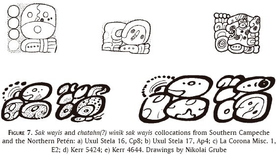
The five stelae in Group A were found by Ruppert and Denison still standing upright in their original position. Three of these stelae are so heavily eroded that their hieroglyphic inscriptions can no longer be deciphered. Stelae 2 and 3, standing in front of two of the highest pyramids of Uxul, Structures A2 and A3, form a male-female stela pair known from Calakmul (Stelae 28 and 29) and other cities under Calakmurs rule (Naranjo Stelae 2 and 3; 22 and 24; 28 and 29), as well as El Peru (Stelae 33 and 34). The well-preserved Stela 2 shows a woman named Ix Ajaw K'ahk'. She faces right towards the much worse preserved Stela 3, a monument displaying a male figure, presumably her husband. Both stelae also share the same Long Count date of 9.9.19.15.0 6 Ajaw 8 K'ank'in (November 25, AD 632). Although, due to erosion, the nature of the event is not clear, there can be no doubt that the inscriptions on both stelae refer to an important moment in the biographies both of the male individual on Stela 3 as well as of Lady Ajaw K'ahk'. The long sequence of titles that follow her name include the glyphs K'UHUL cha?-TAHN-wi-WINIK, k'uhul chatahn(?) winik and SAK WAY-si, sak wayis (figure 5).

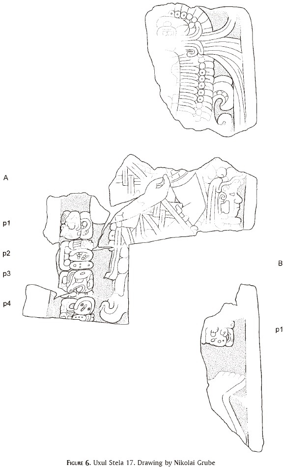
The hieroglyph k'uhul chatahn(?) winik "Holy chatahn person" also appears in Calakmul during the Early Classic (as part of a ruler's name on Stela 43 and on the Hieroglyphic Bench from Structure XX), and during the Late Classic in the name of a sculptor on Stelae 51 and 89 (Grube, 2004: 121-122). The hieroglyph is also part of the name-phrases of rulers from certain other polities and is very common on codex-style ceramics—which were produced under the patronage of a lord bearing this title. The status of Chatahn as a distinct political entity of one kind or another is emphasized on the altar from Altar de los Reyes, where it is followed by some twelve conventional emblem glyphs, including that of Calakmul (Grube, 2008: 182). The second hieroglyph, sak wayis, shares a similar distribution and is particularly common on codex-style ceramics, as well as in the inscriptions of La Corona (figure 7c, d, e) (6). This strongly suggests that Lady Ajaw K'ahk' had married into the Uxul family, and that her hometown is the place which used the chatahn winik and sak wayis titles, and which was one of the principal workshops of codex-style ceramics. The presence of these titles at Calakmul in the Early Classic suggests a strong connection with this city. However, codexstyle sherds carrying these titles have also been unearthed at Nakbe and Tintal (Hansen et al., 2006). As an alternative, it seems also possible to interpret the sak wayis title as the name of an important local family from Uxul. This interpretation is supported by two other occurrences of the sak wayis glyph on Uxul Stelae 16 and 17 (figures 6 and 7a, b). The context of the sak wayis glyph on the undated Stela 16 is not well understood. Stela 17, an Early Classic monument which was recarved during the Late Classic period, carries a hieroglyphic inscription referring to the dedication of a kind of "throne?-stone" which is said to have been in the possession of u mam sak wayis, "the grandfather/the forefather of sak wayis" (figure 6; Grube and Paap, 2010). Stela 17 was erected on top of the heavily looted pyramid M1 on the south end of the large plaza between Groups D, M, C and Structure K1, excavated during the first three field seasons of the Uxul Archaeological Project. This pyramid could have been the ancestor shrine of the sak wayis family in Uxul.
Strong evidence for the domination of Uxul by Calakmul emerges after 636 AD, right after the greatest of all Maya kings, Yukno'm Ch'een II ("the Great") had taken power in Calakmul. Just a few years earlier, the leaders of the mighty Kaan 'Snake' dynasty had shifted their capital from Dzibanche in the northeast to the southwestern site of Uxte'tuun, as Calakmul was known back then, and had started a productive and innovative architectural program at their new seat of power (Delvendahl, 2008; Martin, 2005; Martin and Grube, 2000). During the following decades, Yukno'm Ch'een II, who reigned for more than fifty years and reached the advanced age of 86, expanded the reach of his kingdom through an unprecedented series of wars and diplomatic enterprises. During the latter half of the 7th century, Calakmul's supremacy was felt intensely in the whole Southern Maya Lowlands, as is attested by the written records on public monuments of various major cities, such as Caracol, Naranjo, Piedras Negras, Cancuen, El Peru, and La Corona.
It seems more than likely that Uxul fell relatively early under the rule of the Kaan dynasty, probably before the mid-7th century. The relation with the Snake kings was cemented during the years of that dynasty's most glorious era, the 'era of three kings' (Martin, 2005), and lasted into the early 8th century. The overlord-ship of Calakmul is most obvious during the reign of Uxul's king Muyal Chaak ("Cloud Chaak"), who acceded to power on 9.11.7.10.19 8 Kawak 7 Sip (April 11, AD 660, on Stelae 6 and 10). His name is attested until at least the period ending date of 9.12.5.0.0 at AD 677, recorded on Stela 10 (Grube, 2008: 223). The stelae of Muyal Chaak, in particular Stela 6 (figure 8), follow an iconographic program known from other sites under the rule of the Kaan dynasty. This includes particular elements of dress, a particular shell pectoral worn by the protagonist, and a jaguar headdress with a tobacco leaf attached to it.

Under the auspices of Muyal Chaak a limestone outcropping in the large plaza east of Structure C7 was carved, representing the ruler in the guise of the god Chaak (Grube and Paap, 2009a). This probably was a counterpart to the two rock sculptures from Calakmul (Carrasco and Vasquez, 2007; Morley, 1933: 201-203). Furthermore, on his Stelae 12 and 13, Muyal Chaak records a scattering rite for the commemoration of the half-K'atun ending of 9.11.10.0.0 (AD 662), which was supervised by Yukno'm Ch'een the Great. The positioning of both stelae on a terrace on the east side of Structure D1 has its counterpart in the position of the Stelae 23 and 24 on a platform of the east side of Structure VI at Calakmul. This suggests that a large part of the remodeling of central Uxul and the adoption of the "Calakmul Site Plan" (see below) occurred under the auspices of Muyal Chaak.
The evidence for Calakmul domination of Uxul during the reign of Muyal Chaak brings up the question of his status in relation to the Kaan king Yuknoom Ch'een. Unfortunately, we are still lacking inscriptions indicating his status as a vassal or yajaw of Calakmul, nor do we have clear evidence for his accession under the auspices of a lord of the Kaan dynasty. Perhaps, this kind of explicit statement was not necessary since the presence of Calakmurs overarching power was felt and witnessed everywhere. A possible scenario would even see in Muyal Chaak a close relative of the family of the Kaan kings who was sent to Uxul in order to secure the loyalty of the city.
The history of Uxul immediately before the accession of Muyal Chaak is recorded in great detail on Uxul Altar 2. Unfortunately, this important monument with one of the longest hieroglyphic texts from the Peten Campechano is in a very bad state of preservation. Not even new photographic techniques have helped to recover significant detail of this long text. In the remaining outlines of the glyph blocks it is still possible, however, to discern the presence of the Uxul title (Grube, 2005), a royal title distinct from emblem glyphs because it lacks the k'uhul "divine" prefix which qualifies its bearer as a divine king. The Uxul title first shows up on Altar 2, erected for the period ending 9.10.10.0.0 in AD 642 by a king preceding Muyal Chaak's rise to power. It is then found on all monuments from Muyal Chaak's reign, as well as on Stela 14 and 15, both erected by Muyal Chaak's successor. The lack of a full emblem glyph at Uxul during the reign of these kings can only be explained as an expression of hierarchy between the powerful Kaan dynasty and Uxul, a city under its dominance.
The clearest evidence that Uxul was under the rule of Calakmul derives, however, from the newly discovered hieroglyphic panels associated with the royal palace and, specifically, with Structure K2 (Delvendahl and Grube, 2011; Grube and Delvendahl, 2011). Displaying kings of the Kaan dynasty engaged in the ballgame, they are testimonies of the profound impact of Calakmul on Uxul's ritual and political life. With the dates of AD 695 and 705, the panels postdate Stela 14, which commemorates the 9.13.0.0.0 K'atun ending (AD 692). By this time, a new king had acceded at Uxul. His name appears on the right side of Stela 14 and, although it is too eroded to be read, is clearly different from Muyal Chaak. The extraordinarily early end of Uxul's dynastic record challenges interpretation, and yet, the proximity of these last dates to the attacks of Tikal against Calakmul and the subsequent end of the Kaan dynasty (Martin, 2005) is very suggestive. Uxul may have been drawn into an early collapse because of its close ties to the fate of its once all-important neighbor.
The Royal Palace of Uxul: Group K and Structure K2
While several sectors of the site, especially around the western aguada, present occupation that dates back at least to the Late Preclassic, the zenith of Uxul's political, economic, and strategic influence was clearly during the 7th and 8th centuries, in the Late Classic. Uxul's location midway between some of the most important centers of the Classic period might have made it a focal point of diplomatic and commercial interest of the superstates of the North and South. By the 7th century, affiliation became unilateral: architectonic, iconographic, and epigraphic evidence confirms over a period of roughly 100 years an exceptionally close relationship to the Kaan 'Snake' dynasty of nearby Calakmul. However, new data seems to indicate that the same close alliance ultimately also led to Uxul's downfall and rapid abandonment by the mid-8th century, as the elite of Uxul and later on the whole city was absorbed in the vortex of events following the defeat of Yukno'm Yich'aak K'ahk by Jasaw Chan K'awiil of Tikal in August 695 AD.
One of the most radical changes that the supremacy of the great city of Calak-mul caused at Uxul was no less than the total transformation of the city's center according to what can be called the "Calakmul Site Plan," mimicking the site core layout of the giant to the northeast. These changes in the physiognomy of the city's center can be linked directly to the time of military and political expansion of the Kaan dynasty during the reign of Yukno'm Ch'een II, in the first half of the 7th century, and the ensuing prosperity to the capital and its closer allies. While only a small number of Uxul's central buildings have been test-trenched, recent excavations of the structures around one of Uxul's central plazas in Groups C and K show that those buildings were apparently built shortly before AD 650 in a single monumental constructive effort. Structures C10 and C5, for instance, show no traces of being built on top of earlier buildings. Structure K2, over 50 meters long and 3 meters wide, located on the south side of one of the main plazas, does enclose a small, delicately painted substructure, whose modest size stands in stark contrast to the massiveness of the later palace building. While this reconstruction process might be understood either as a visual expression of the total subjugation of Uxul or, rather, as a manifest of the close bonds of this city to its superior, there can be no doubt that this direct influence by the powerful Kaan kings also had a major impact on the political and social organization of Uxul.
The similarities in the general layout of the main buildings in the site center are obvious by contrasting the maps of both sites, but they are even more impressive when comparing architectural features such as building size, style, and configuration. In both cities, several central plazas form an east-west axis around which the tallest, most voluminous, and therefore probably most important structures are located. The E-groups in the two sites (Structures IV and VI of Calakmul, Structures D1 and D3 of Uxul) are of similar size and exhibit the particularity of two stelae erected on the western building. In the case of Uxul's Structure Dl, one of these stelae mentions the supervision of a ritual by Calakmul king Yukno'm Ch'een II. The south side of the same plaza in both cities is delimited by the largest building of the settlement, acropolis-type Structures II of Calakmul and Ll of Uxul. While Structure II of Calakmul is much higher and more voluminous than its counterpart in Uxul, this is clearly due to its over 1300 years of constructive history (400 BC to AD 900). The north end of the two plazas is closed off by a major temple-type structure (Structure VII of Calakmul and Structure D2 of Uxul), displaying several stelae on its main, southern side. Both Structure II and Structure VII of Calakmul house the tombs of two of the most powerful kings of the late 7th and early 8th centuries, Yukno'm Yich'aak K'ahk' and Yukno'm Took K'awiil. It remains to be seen if similarly important burials were placed in Structures Ll and D2 of Uxul.
Towards the west of these main precincts of the two cities lie the plazas that include the only ballcourt of the settlements. At both sites, the ballcourts are laid out in north-south direction and are of surprisingly modest size, compared to other ballcourts of the Southern or Northern Lowlands. The Calakmul ballcourt is about 20 m long by 23.2 m wide (in total) with side structures of approximately 8.6 m in width and no more than 3 m in height each in their present condition. The Uxul ballcourt is even smaller, with only 15 m in length by 16.5 m in width and side structures which do not rise higher than l.8 m in their current condition. Both ballcourts are directly associated with the main palace complexes of the city, the Great Acropolis Group of Calakmul and Group K of Uxul, respectively. The close association of ballcourts to the main palace complexes, an arrangement also observable at many other southern Maya sites, is a pattern that remains to be studied systematically.
The Palace Group of Uxul itself shares a whole series of similarities with the main palaces of Calakmul, the so called Small Acropolis (Pequeña Acropolis), and the Great Acropolis Group (Grupo Gran Acrópolis). Beside their central location, similar configuration—albeit on a much smaller scale at Uxul—and almost identical architectural style and composition, most notable are the spacious courtyards of the palace groups in the two cities. The largest patio of Group K measures some 45 x 50 meters (2 250 m2), comparable to Court B behind Structure XVI of Calakmul's Great Acropolis Group (Delvendahl, 2010: 621).
Group K (figure 9) is located on the south side of one of Uxul's central plazas in the area of highest topographic elevation. The huge plaza north of the palace, with an extension of 170 by 110 meters (18 700 m2), is surrounded by various structures and pyramids of ritual type and contains the ballcourt. To the south of Group K extends an open area of seemingly little occupation, where some of Uxul's most extensive central quarries are located. It can be assumed that most of the construction material for the palace group and other buildings in the central area was extracted from these quarries. Group K qualifies as a medium-size palace complex, with a maximum extension of 110 by 130 m and 17 buildings, platforms, and walls arranged around five courtyards. At least 11 of these, Structures K2 through Kll and K27, can securely be identified as vaulted, range-type buildings. The extension of the complex and the number of constructions suggest a variety of functions for the different sectors of the group, including spaces for ritual performance activities and political-administrative affairs, as well as residential areas.
During the palace group's occupation, confirmed by the recent explorations at least for the 7th and 8th centuries, the principal access to the complex was through Structure K2, leading the visitor from the main plazas to the north into the extensive Northeast Court within the palace compound. Apart from K2, the Northeast Court is surrounded by three long, range-type structures (Structures K3, K4, and K5), which completely enclose the patio except for small passageways in the four corners of the court. As revealed by multiple looters' trenches, most of the walls of the buildings were finished with carefully worked veneer stones covered by several layers of thin stucco. Structure K3 on the east side of the Northeast Court and Structure K4 on the south side both exhibit two elongated galleries, between 2.37 and 2.50 m wide each, divided into individual rooms by several very well-preserved transverse walls. Most of these rooms seem to have housed L-shaped benches, similar to those excavated in Structures K2 and K8. The exterior walls of both structures are about 1.15-1.30 m thick. In addition, Structure K4 has wide lateral rooms, with doorways opening to the east and west, which are clearly distinguishable from the surface. Both are about 5.80 m long and 2.80 m wide, with an interior space of over 16 m2.
Directly to the west of the extensive Northeast Court lies the second most important courtyard of the palace group, the West Court. Much more intimate, this patio is less than a quarter of the size of the Northeast Court, and most probably had residential functions. It is surrounded by Structures K5, K6, K7, and K8. Excavations in the past two years in Structure K7 and K8 have strengthened the notion of the residential character of that patio, as the liberation of the rooms revealed enormous benches of up to 10m2 in surface, occupying the larger part of the interiors of the structures. This is especially notable in Structure K8, where large benches fill all three rooms which open towards the patio interior. While the benches have been dug into and looted horizontally from the south, their surface and northern façade are still exceptionally well preserved. Together with the thick stucco of the floor and the white smoothed stucco from the interior walls they form rooms of an almost fluid, undulating architectural flow, basically without corners. While excavating the northern platform and the stairway leading up to Structure K8 from the patio, a well preserved south-facing substructure of probably two entrances came to light. This substructure was subsequently used as a construction unit (cajón de relleno), filled with stones and rubble, to be transformed into a large platform for a new northward-facing superstructure. Analysis of the ceramic material from the platform, together with the new evidence from Structure K2 (see below) will undoubtedly shed light on the very moment when the location that later became the setting for Group K was transformed from an area of scattered individual buildings facing in different directions into a highly intricate and closed palace complex.
To the south lie two additional smaller courtyards, one of which, the Southwest Court, is dominated by an impressive building, Structure K11, which was partly excavated in 2012. A wide stairway leads almost three meters up to a 1.5 m wide platform and a single gallery building with three entrances. The elongated gallery was later subdivided into three single rooms by small transverse walls of roughly cut stone. Right underneath the floor of the central room, a total of three burials were discovered. Given the prominence of the building and the quality of smaller objects found during excavation, these were surprisingly simple, consisting of uncapped cists, with horizontally aligned stone slabs and a modest offering of two-three bowls and plates of Infierno and Tinaja type each. Though disarticulated, the skeletal remains in of the westernmost cists were surprisingly well preserved, with pronounced cranial modification.
The Southeast Court is delimited by the southern façade of Structure K4 on its north side, by Structure K12 on its west side, and by an elongated wall which runs all around its southern and eastern end. Excavations in 2012 have confirmed the nature of this wall and have exposed high concentrations of debris on its interior and, especially, on its exterior, southern, side. A low, multi-angled construction of what might be the remains of a foundation wall for a perishable superstructure within this southern courtyard could possibly be hypothesized to be a kitchen and food preparation area, which would explain the high amount of rubble, but this assumption will have to be tested in future excavations.
Most of the structures of the palace complex suffered heavy looting in the decades of the '80s and '90s. Some, such as Structures K3 and K5, are scarred by up to eight looters' trenches with destructive tunnels that cross almost the entire building and were dug into most of the benches in search of caches and burials. One of the few structures that fortunately escaped major looting is Structure K2, the principal building of the palace complex and, besides its obvious function as access to the palace group, one of the most imposing and ritually significant structures of Uxul. Partly for these reasons, Structure K2 has been the principal focus of the explorations of the Uxul Archaeological Project since 2011 and the location of some major discoveries of the past two field seasons.
In its present ruined condition, Structure K2 (figure 10) is a roughly 60 meter long mound, which rises some 9.6 m above the actual level of the northern plaza. Surface observation and excavations in the 2011 and 2012 field season indicate that the superstructure was originally only about 30 m long and 9.5 meters wide. Two lateral extensions were added at some later date, extending the whole superstructure to well over 54 meters. Including the platforms and original northern and southern stairway, the whole structure measured in its north-south width extension some 25.5 m, with the Late Classic and early Terminal Classic extensions of the stairways bringing it close to 31 meters. The superstructure accommodates two long galleries, each about 2.32 m wide and possibly up to 4 meters high. The galleries were separated by a massive 2.5 meters thick central wall, while the exterior walls were over 1.3 meters thick.
The two galleries were subsequently divided into different chambers by small walls partly of re-used worked stone and partly of rough stone. A total of five entrances pierce through the northern and the southern façade, three of which connect the two galleries via passageways through the central wall. The central passageway, 2.41 m wide, is aligned with the northern and southern entrances (both about 2.61 m wide), which theoretically allows a more direct access to the inner courtyard and therefore can be regarded as the principal, if not only official access way to the palace group. The two passageways in the eastern and western section of K2, on the other hand, are slightly offset in regard to their corresponding entrances in the north and south walls. Large platforms, 3.8 meters wide on the public north side, and 4.3 meters wide on the more private south side, provided ample space for gatherings and (semi-) public presentations. Both platforms are accessed via broad stairways, the one on the north being about 22 meters wide, and the one on the south measuring almost 15 meters.
The original height of the superstructure can be estimated to have been somewhere around 5-6 m. Thick modeled stucco found in the debris seems to indicate that the building was once decorated, while traces of red paint on the interior walls are a sure sign that the building was at least partly painted on its exterior and interior walls. The excavations of the past two years have confirmed that the construction of the massive superstructure can be dated to the first half of the 7th century. However, recent excavations under the northern gallery of Structure K2 have also revealed an earlier and much smaller substructure, which seems to have been the very first construction in that area of Uxul. The corresponding floor was leveled right onto the bedrock of an extensive, 3-4 meter high natural elevation. The substructure itself (figure 11) was built directly on that floor, without the usual basal platform, and seems to have been of modest size and probably covered with a perishable roof. The central doorway, however, was carefully sealed and covered with a thin stucco layer painted in light greyish purple. The northern façade of the structure was likewise delicately painted with bordering red and orange stripes and a pinkish background, not unlike the color palette of the newly discovered wall paintings of Xultun (Saturno et al., 2012).
The 2011 excavations of Structure K2 concentrated on the central section of the building, where surface inspection clearly pointed to the presence of large stairways and platforms on its north and south sides. The excavation of the southern stairway uncovered a total of five rows of steps of varying width between 0.7 and 1 meter, each row measuring 14.8 meters in length, and in total made out of 260 individual stone blocks. Of these 260 stone blocks, four stones in the central section of the first and the second row present images and glyphic inscriptions. Three (Southern Stairway Panels 1, 2, and 4) are covered with images of ballplayers and short inscriptions in two sections (in most cases partly destroyed), while a fourth (Panel 3) is fully glyphic. Two additional sculpted stone blocks were located in a 4 m wide trench on the north stairway of Structure K2 (Northern Stairway Panels 1 and 2). Panel 1 shows ballgame imagery identical to Panels 1, 2, and 4 of the southern stairway, while Panel 2, found face up and apparently out of context in the lower section of the northern stairway, is fully glyphic. The general dimensions of the monuments, around 30 cm x 34 cm x 20 cm (height, width, thickness), as well as their location, imagery, content, and depicted historical figures, make the new Uxul monuments most comparable to the stone blocks of La Corona Hieroglyphic Stairway 2, attributed to Structure 13Q-6 of that site (Canuto and Barrientos, 2010: 249, 265).
In all examples, the stepped ballcourt is marked with a personified K'AN sign and maize foliage attached to it, which is the full version of the NAL logograph. The whole compound reads as k'anal and has to be understood as an attribute of the stairway, describing it as a "precious" stairway, or as a stairway of a particular size (k'aan in Yucatec is a measuring unit, mecate). A reference to a k'anal eb' stairway is also found at Copan, where the step from Ante structure is labeled with this name (Morales, Miller and Schele, 1990).
The ballplayers on the four panels can be identified as rulers from Calakmul. On Northern Stairway Panel 1 and Southern Stairway Panel 1 the name glyph is destroyed but the Snake emblem glyph and a kalo'mte' title have survived; Panels 2 and 4 of the southern stairway represent Yukno'm Ch'een II ('the Great') and his son Yukno'm Yich'aak K'ahk', respectively. The text on the latter indicates a date of 3 Imix 19 Kumk'u, on which day Yukno'm Yich'aak K'ahk' pi-tzi-ja, pitz-aj, "plays ball". The date, corresponding to 9.13.2.17.1 3 Imix 19 Kumk'u, or February 10, AD 695, falls just about 6 months before the presumed death of this Calakmul king at the hands of Jasaw Chan K'awiil of Tikal in August of AD 695.
The glyphic panel from the southern stairway, Panel 3 (figure 13) (12), carries an inscription of six glyph blocks, starting with a date that can be reconstructed as 8 Ajaw 8 K'ayab, for which the most likely position in the Long Count would be 9.13.13.0.0 (AD 705). The next glyph is PAT-la?-ja? 8-AJAW-NAAH, patlaj waxak ajaw naah "it is built in stone the 8 Ajaw house". The phrase clearly refers to the construction or inauguration of a house, which is named after the Calendar Round 8 Ajaw. The naming of houses after dates is a common practice in the Maya Lowlands; other examples are known from Calakmul ("Six Ajaw" on a capstone from a group with the same name), Tikal ("Nine Ajaw House" on Altar 5, Glyph 18), Copan ("Nine Ajaw House" on 10L-22). The next glyph (B2) introduces the name of the agent of the house dedication: u-KAB'-(ji)-ya ?-na-ke-KELEM, u kabjiiy ?-na kelem, "by the authority of ?-Kelem". The name is not known from other inscriptions at Uxul or at Calakmul. The following glyph block (A3) adds another title or part of the nominal phrase AJ-pi-tzi-K'IHNICH, aj pitz k'ihnich "he, the ballplayer-sun god". The long nominal phrase ends with a glyph composed of various signs, including a dotted scroll and probably a K'awiil head. Although this glyph is very destroyed, the remaining detail show some resemblances to the name of "Scroll-head K'awiil", a Kaan king who appears on Dos Pilas Stela 8. It is possible that this individual is the then reigning Yukno'm Took' K'awiil, whose name displays a great amount of variation. The preceding names on Panel 3 can probably be understood as other names of this king, possibly as his pre-accession names. If the identification of the name is correct it would indicate that Calakmul continued to exercise control over Uxul even after the AD 695 defeat of Yukno'm Yich'aak K'ahk'.

However, shortly thereafter, the influence of the Kaan dynasty must have waned, as the stone panels were ripped out of their original context and, probably around AD 740, reset in their final location in the very last architectural extension of the stairways. The full glyphic block of the southern stairway (Panel 3) was placed sideways (rotated by 90°) into the line of stones of the first step. Of the two monuments encountered on the northern stairway, the one with inscriptions and figural representation (Panel 1) was even set head down (rotated by 180°) into the line of steps. By doing so, the late inhabitants of the palace compound deliberately desecrated the monuments in an attempt to humiliate posthumously the represented and mentioned sovereigns of the once powerful ally.
In the turbulent years of the mid-8th century, the new occupants of the slowly decaying spaces of the palace complex did not last long. Analysis of the ceramics of Uxul show that less than 1 % of all ceramics so far excavated at the site belong to the Terminal Classic period. A tremendous decline in population seems to have taken place starting around AD 750. While the political system was disintegrating, warfare was at the doorstep, as relatively high amounts of spear points recovered on the surface of the Northeast Court and around the southern edges of the royal palace complex seem to suggest. The final chapter of Uxul, current data indicates, was a violent one, even if we lack information how long the process lasted. All the while, other, formerly tightly controlled factors were falling apart as well. One of these was the site's vitally important water management system.
The Challenge of Water Supply and Uxul's Hydraulic System
A significant prerequisite for the founding and growth of the settlement of Uxul was the assurance of a constant water supply for all of its inhabitants. Archaeological investigations of three monumental hydraulic features in the past four field seasons have demonstrated that the drastic water scarcities during the dry seasons made it necessary to develop a sophisticated hydraulic system in order to satisfy the needs of a growing population.
As is well known, the availability of water in the Petén Lowlands is highly problematic for two basic reasons. For one, the whole Yucatán Peninsula consists of a permeable limestone block which is almost devoid of surface water. Secondly, the climate of this region is marked by the pronounced seasonality of rainfalls, which manifest themselves in the distinctly separated rainy season and dry season. The problems deriving from this water scarcity were recognized since the very beginnings of Maya archaeology (Stephens, 1843, II: 165) but were not systematically investigated before the early 1970s. Prior to that time, the general conception of water supply in the Maya Lowlands was based upon the assumption that the climatic conditions during the Late Classic period had been much more favorable and humid (Cooke, 1931). Although these premises had never been proven by field studies, this postulate of generally more humid conditions was accepted by the majority of the scientific community until the early 1980s (Dunning, Beach and Rue, 2006: 85). Around that time, the first pollen diagrams were extracted within the Central Maya Lowlands and thereby enabled reconstructions of climatic conditions during pre-Hispanic times (Turner and Harrison, 1983: 251). Many of the resulting climate reconstructions suggested that conditions during the Late Classic period in the Central Maya Lowlands had been similar to contemporary conditions (Shaw, 2003: 160; Beach et al., 2003). It can be therefore assumed that the task of providing a constant water supply in Maya cities during the Late and Terminal Classic was as challenging as it is in these remote areas today. Since regional explanations for water supply, such as transportation of water from perennial sources, are highly unlikely, local models have to be envisioned: each settlement needed to ensure that the local water sources permitted a sufficient provision for all inhabitants during the entire year.
The key to such a provision laid in collecting and storing a portion of the surplus precipitation from the rainy season by developing a water-storage system for the dry season. Such artificial reservoirs could be created either through increasing the size and impermeability of natural depressions or through the more labor-intensive construction of new reservoirs. Both approaches involved large-scale landscape modifications which nowadays can still be perceived in the settlement landscape. As the settlement map clearly illustrates (figure 14), three major hydraulic features can be identified at Uxul: (1) the Aguada Occidental, (2) an influx channel to the Aguada Occidental and (3) the Aguada Oriental. A striking peculiarity is visible in the location of these hydraulic features: not only do the Aguada Occidental and the Aguada Oriental share the same size, form and extent, but they are also situated on the same east-west axis. As the density of occupation decreases markedly beyond the two reservoirs, they furthermore might have served as visual markers of the eastern and western boundaries of the settlement.
Upon the basis of the present excavations, it seems that the earliest constructions at Uxul began near the Aguada Occidental, which is not surprising given that the earliest inhabitants were necessarily dependent on a natural water source for permanent settlement. The Aguada Occidental, with an almost perfectly rectangular shape, measures roughly 100 by 100 m and was discovered and described by Ruppert and Denison (1943) in 1934. Within the landscape, this aguada is situated within a naturally low-lying area to the west of Uxul's central settlement hilltop. Due to this location and the large size of the catchment area, it is fed by substantial amounts of runoff. The immediate topographic surroundings and the proximity to a bajo environment indicate that the Aguada Occidental constitutes a modification of an already existing natural aguada. For this modification, the constructors removed the aguada's natural, alluvial sediment until the level of the natural sascab. In this process a 3 m deep rectangular basin with an artificially flattened ground area and uniformly sloped embankments was excavated. During the subsequent working stage, a close pavement was built out of unworked limestone slabs. This base modification served to impede water seepage and enabled the storage of bigger quantities of water for the critical dry seasons.
When the modification of the Aguada Occidental no longer sufficed to store water for the entire dry season, Uxul's inhabitants chose to reduce the seepage of precipitations by connecting the catchment area between Groups A and B and the reservoir's southeastern corner via a canal. For this purpose, a highly compact 2.80 m wide pavement of limestone slabs was set between two vertical walls of long flags (figure 15). Thereupon, these 40 cm high vertical walls were on both sides enclosed by 80 cm wide and 40 cm high embankments of stones in order to reinforce the long flags laterally. Finally these embankments were delimited on both sides by low stone walls.
The high-quality pavement, in conjunction with the lateral walls, accelerated the flow rate and thereby effectively impeded water seepage. By means of this canal, it became possible to extend the reservoir's catchment area and thus increase the amount of stored water. Due to the construction of a logging road in the 1980s, the canal's origin in the elevated terrain between Groups A and B has become obliterated. Currently, the canal can be observed for a length of 50 m.
The Aguada Oriental, which measures approximately 100 x 100 m and features a nearly perfectly rectangular form, was discovered in March 2009. An interesting peculiarity of this reservoir is a linear depression of 15 in length in the middle of the southern bank, which obviously served to direct rainfall from the southern catchment area into the aguada. Excavations revealed that this reservoir did not originally constitute a natural depression, but that this selva alta location was rather consciously selected for the creation of a new reservoir.
During the first stage of work, a rectangular basin with a depth of 2.50 m was cut into the bedrock, while the 3 m wide slope zones were given the same inclination. In this process, a 15 m long and 4 m wide semicircular depression, which was positioned exactly in the middle of the southern embankment, was cut into the bedrock. At the north end of this dipping canal, a 40 cm high and 180 cm wide pedestal of bedrock was left standing (figure 16). Upon this pedestal, massive carefully cut limestone blocks were assembled in four rows to form a 1.20 m high wall which partially blocked the canal's northern end (figure 17). The basin's ground area was so carefully leveled that the final bedrock surface exhibited only the most minute height difference from the center to edge of the reservoir.
In the following constructive step, several thousand partially broken plates or low bowls were accurately placed upon this finely leveled bedrock surface in a preferably tight bond (figure 18). These discarded plates and low bowls had obviously been collected during a long period and stored for this specific purpose, since only fragments with low curvatures could be documented at the reservoir base.
Evidently, the reservoir's engineers had purposefully collected these specific fragments in order to assemble them into a layer with a preferably even surface. This ceramic layer served as a leveling element between the underlying bedrock and the subsequent constructive element.
During the next working stage, a pavement of flat limestone slabs was placed upon this layer of ceramics (figure 19). These limestone slabs, which were presumably produced during the excavation of the bedrock, were cut to a uniform height of 5-7 cm and feature dimensions of 10 x 8 cm up to 40 x 28 cm. In order to create a solid surface, they were carefully assembled into a very homogenous pavement and finally covered with a surprisingly solid stucco matrix. Due to this accurate layout, this concluding construction element minimized water seepage and could mostly be documented in its intact state. Through its position within the installation the wall feature can easily be identified as a "filter wall" which served to purify the rainwater from the southern catchment area streaming in via the southern influx channel from higher ground. The wall's elevated position supposedly facilitated the deposition of debris. If these particles were removed on a regular basis, this construction element clearly would have improved the reservoir's overall cleanliness.
It is crucial to emphasize that the hydraulic system was developed in all likelihood to ensure a provision of potable water to the site. Both reservoirs definitely lack discharge channels. Owing to this constructive layout, the users of these reservoirs had to scoop out the stored potable water with large storage vessels and subsequently transport it to their respective living quarters. The high accuracy of these constructions points to a certain amount of experience in the design and layout of such features. However, potential predecessors of these sophisticated constructions are unknown to date since only few hydraulic features have been investigated within the Central Maya Lowlands. While it might seem slightly excessive to speak of Uxul's "hydraulic system", the overall combination of its very strategic composition, the adaptation to the local landscape, and particularly its finely coordinated constructional elements, can be defined as a complex hydraulic system (Matheny et al., 1983; Seefeld, 2008).
As mentioned above, the creation of new water storage features involved large-scale landscape modifications. The recruitment of labor for such public building activities required central supervision and an overseeing authority. Still, the layout of the three investigated hydraulic features shows that each individual constructive element, including its exact position, had to be planned in all details prior to the actual construction works. The results of excavations in these hydraulic features and their finely coordinated constructive elements suggest that they formed part of a building program planned over the long term. The site's rulers presumably were well aware of the fatal risk of an ebbing water supply in this environment and therefore used a considerable portion of their disposable labor in order to ensure a constant water supply. Elaborating upon this consideration, it could be argued that the indemnification of the water supply ultimately belonged to the ruler's responsibilities. Nonetheless, the development of this hydraulic system was a highly dynamic process. New water storage features were obviously constructed only when a demographic stress had overstrained previous constructions.
The fundamental necessity of a powerful elite for the planning, enforcement, and maintenance of such a large-scaled hydraulic system does not only become apparent in its completion, but also in its destruction. During the archaeological investigation of the Aguada Occidental in the 2010 field season, a small circular depression was documented in the pavement surface. After excavating a cross-section through the center of this feature it became evident that this depression had been excavated after the initial construction of the pavement (figure 20).
During a period of most desperate water scarcity, the local population obviously accepted the partial destruction of an intact pavement in order to extract minute water quantities in the short term. Considering the amount of recruited labor, it seems highly unlikely that the local elites that had supervised the original construction were still exerting power when the system's destruction took place. Upon the basis of these observations it seems reasonable to state that a hierarchical society and the ruling of a central power were integral to the development and maintenance of such a sophisticated hydraulic system. When the central authority collapsed, the Terminal Classic inhabitants of Uxul were lacking the social cohesion to protect the infrastructure, which originally enabled their survival in this harsh environment.
Conclusions
The preliminary results of the first four years of systematic research at Uxul confirm that it was a medium-sized city with a population of approximately 5 000 people. The limits of the site were defined by the seasonally inundated bajos. Occupation at Uxul seems to have begun at the edge of the bajo to the west at some time during the late Middle or Late Preclassic period, corresponding to a pattern observed in other cities in the region as well (Scarborough, 2003: 111). This location certainly was chosen due to the proximity to the western aguada as a source of water. Evidence of sparse early settlement can also be found on the nearby meseta, which in the Early Classic became the focus of monumental construction. However, the peak of Uxul's occupation was reached during the Late Classic, when the site spread over at least three adjacent hilltops and featured a wide range of architectural diversity, especially in the size and form of its residential groups.
Very little is known about Uxul's ruling elite during the Early Classic period. A single stela fragment and the sides of the reworked Stela 17 provide evidence of limited monument erection during that period. The majority of Uxul's inscribed monuments dates to the 7th century of the Late Classic. During that time, following the establishment of the Kaan dynasty at Calakmul, iconographic and epigraphic information suggests an incorporation of Uxul into Calakmul's political sphere. It still remains to be seen whether Uxul became a provincial capital of a hierarchically organized regional state headed by Calakmul, or whether it remained simply a loosely integrated vassal state of the Kaan dynasty, possibly connected to its superior through kinship ties.
Calakmul's impact on Uxul is strongly marked all over the site, but is particularly obvious in the site center, which seems to have undergone radical changes after its incorporation in the Calakmul political sphere. The transformation of Uxul's center according to what can be called the "Calakmul Site Plan" can be linked directly to the time of military and political expansion of the Kaan dynasty during the reign of Yukno'm Ch'een II (AD 636-686). Recent excavations of the buildings around one of Uxul's central plazas in Groups C and K show that those buildings were apparently built in a single monumental construction effort shortly before AD 650. While this reconstruction process might be understood either as a visual expression of the total subjugation of Uxul or, rather, as an indication of the close bonds of this city to its superior, there can be no doubt that this direct influence by the powerful Kaan kings had also a major impact on the political and social organization of Uxul.
The epigraphic history of Uxul is unusually short, coming to a close with the 9.13.13.0.0 (AD 705) date on Southern Stairway Panel 3. This falls shortly after the first defeat of the Kaan dynasty by the hands of Tikal in AD 695 and only a few decades before the second and decisive defeat of the Kaan dynasty in 736 (Martin and Grube, 2000: 110, 113), suggesting a direct connection between the end of elite activities at Uxul and the downfall of its overlord. Uxul may have become so dependent on its connection to the Kaan dynasty that its downfall also implied the disintegration of its own political system. Only a few decades later, starting around [AD] 750, the small amount of Terminal Classic ceramics recovered so far in excavations suggests a tremendous decline in population, establishing a link between the political collapse and the reduction of population which characterize the general collapse of Maya cities during the 9th century.
Research on the water storage features of Uxul provides stunning new insights into the role of the hydraulic system which apparently was necessary to maintain a large population at the site. Excavation of the aguadas has shown that their construction required much more labor input, large-scale landscape modification, and planning than has been previously assumed. Such large public building activities and the constant maintenance of aguadas and water channels needed central supervision and an overseeing authority. With the early disappearance of Uxul's royal elite, the central power which was integral to the development and maintenance of such a sophisticated hydraulic system had vanished. As a result, the availability of water for the inhabitants of the settlement was drastically reduced.
Archaeological research at Uxul helps to fill the gap in our understanding of the processes and dynamics that led from the political to the socio-demographic collapse of Maya cities. At Uxul, the decline of population can be related to the slow decay of infrastructure, in particular of the hydraulic system, which followed the collapse of the elite and the disappearance of central power and administration. The results of four years of fieldwork at Uxul, therefore, force us to look more closely at the impact of the collapse of political-administrative structures, and in turn, at the internal political organization of ancient Maya communities.
REFERENCES
Adams, Richard E. W. 1980 "Swamps, Canals, and the Locations of Ancient Maya Cities", Antiquity, 54: 206-214. [ Links ]
Ashmore, Wendy. 1981 "Some Issues of Method and Theory in Lowland Maya Settlement Archaeology", Lowland Maya Settlement Patterns, Wendy Ashmore (ed.), Albuquerque: University of New Mexico Press, 37-69. [ Links ]
Aveni, Anthony F., and Sharon L. Gibbs. 1976 "On the Orientation of Precolumbian Buildings in Central Mexico", American Antiquity, 41 (4): 510-517. [ Links ]
Beach, Timothy, Sheryl Luzzadder-Beach, Nicholas P. Dunning, Jon Hageman, and John Lohse 2003 "Upland Agriculture in the Maya Lowlands. Ancient Maya Soil Cultivation in Northwestern Belize", Geographical Review, 92: 372-397. [ Links ]
Becker, Marshall J. 2004 "Maya Heterarchy as Inferred from Classic-Period Plaza Plans", Ancient Mesoamerica, 15: 127-138. [ Links ]
Carrasco, Vargas y Verónica A. Vázquez López. 2007 "Nuevas evidencias del Clásico Temprano en el registro arqueológico del reino de Ka'an", Los Investigadores de la Cultura Maya 15(1): 155-165. Campeche: Universidad Autónoma de Campeche. [ Links ]
Cooke, C.W.. 1931 "Why the Mayan Cities of the Petén District, Guatemala, Were Abandoned", journal of the Washington Academy of Sciences, 21: 283-287. [ Links ]
Delvendahl, Kai. 2008 Calakmul in Sight. History and Archaeology of an Ancient Maya City. Mérida: unas letras industria editorial. [ Links ]
----------, 2010 Las sedes del poder. Evidencia arqueológica e iconográfica de los conjuntos palaciegos mayas del Clásico Tardío. Mérida: Universidad Autónoma de Yucatán. [ Links ]
Delvendahl, Kai, and Nikolai Grube. 2011 "The Last Hurrah! Yukn'om Yich'aak K'ahk's Final Game on Uxul Panel 4", Mexicon, XXIII (4): 86-88. Markt Schwaben [Germany]: Verlag Anton Saurwein. [ Links ]
Dunning, Nicholas P., Timothy Beach, and David Rue. 2006 "Environmental Variability among Bajos in the Southern Maya Lowlands and its Implications for Ancient Maya Civilization and Archaeology", Precolumbian Water Management, Lisa J. Lucero and B.W. Fash (ed.). Tucson: The University of Arizona Press, 81-99. [ Links ]
Dunning, Nicholas P., Sheryl Luzzadder-Beach, Timothy Beach, John G. Jones, Vernon Scarborough, and T. Patrick Culbert. 2002 "Arising from the Bajos: the Evolution of a Neotropical Landscape and the Rise of Maya Civilization", Annals of the Association of American Geographers, 92 (2): 267-283. [ Links ]
Grube, Nikolai. 2004 "El origen de la dinastía Kaan", Enrique Nalda (ed.). Los cautivos de Dziban-ché. México: Instituto Nacional de Antropología e Historia, 117-131. [ Links ]
----------, 2005 "Toponyms, Emblem Glyphs, and the Political Geography of Southern Campeche", Anthropological Notebooks, XI: 89-102. Slovene Anthropological Society. <http://www.drustvo-antropologov.si/AN/PDF/2005_1/Anthropological_Notebooks_XI-1_6.pdf> [Retrieved October 24, 2012. [ Links ]]
----------, 2008 "Monumentos esculpidos: epigrafía e iconografía", Reconocimiento arqueológico en el sureste del estado de Campeche, México: 1996-2005, Ivan Sprajc (ed.). Oxford: British Archaeological Reports International Series 1742, 177-231. [ Links ]
Grube, Nikolai, and Kai Delvendahl. 2011 "Los jugadores de pelota de Uxul, Campeche", Arqueología Mexicana, XIX (112): 64-69. México: Raíces. [ Links ]
Grube, Nikolai, and Iken Paap. 2008 "La exploración de Uxul, Petén Campechano: Resultados de las Investigaciones en el 2007", Los Investigadores de la Cultura Maya, 16 (2): 267-287. [ Links ]
----------, 2010 "Uxul, Petén Campechano: Primer Temporada de Campo, 2009", Los Investigadores de la Cultura Maya, 18 (2): 9-24. [ Links ]
Hansen, Richard D., Beatriz Balcárcel, Edgar Suyucm, Héctor E. Majía, Enrique Hernández, Gendry Vallem, Stanley P. Guenter, and Shannon Novak. 2006 "Investigaciones arqueológicas en el sitio Tintal, Petén", XIX Simposio de Investigaciones Arqueológicas en Guatemala, 2005, Juan Pedro Laporte, Barbara Arroyo and Héctor Mejía (eds.). Guatemala: Museo Nacional de Arqueología y Etnología, 739-751. [ Links ]
Haviland, William A. 1972 "Family Size, Prehistoric Population Estimates, and the Ancient Maya", American Antiquity, 37 (1): 135-139. [ Links ]
Marcus, Joyce. 1973 "Territorial Organization of the Lowland Classic Maya", Science (180): 911-916. [ Links ]
Martin, Simon. 2005 "Of Snakes and Bats. Shifting Identities at Calakmul", The Pari Journal, VI, (2). San Francisco: Pre-Columbian Art Research Institute: 5-15. <http://www.mesoweb.com/pari/publications/journal/602/SnakesBats.pdf> [Retrieved October 24, 2012. [ Links ]]
Martin, Simon, and Nikolai Grube. 2000 Chronicle of the Maya Kings and Queens. Deciphering the Dynasties of the Ancient Maya. London / New York: Thames and Hudson. [ Links ]
Matheny, Ray T., Dean L. Gurr, Donald W. Forsyth, and F. Richard Hauck. 1983 Investigations at Edzna, Campeche, Mexico, Vol. 1. Part 1: The Hydraulic System. Provo [United States]: Brigham Young University (Papers of the New World Archaeological Foundation, 46). [ Links ]
Miller, Mary Ellen, and Stephen D. Houston. 1987 "Stairways and Ballcourt Glyphs: New Perspectives on the Maya Ballgame", Res, 14: 47-66. [ Links ]
Morales, Alfonso, Julie Miller, and Linda Schele. 1990 The Dedication Stair of "Ante" Temple. Austin: Copan Mosaic Project / Instituto Hondureño de Antropología e Historia (Copán Note, 76). [ Links ]
Morley, Sylvanus G. 1933 "The Calakmul Expedition", Scientific Monthly, 37: 193-206. [ Links ]
Rice, Don S., and T. Patrick Culbert. 1990 "Historical Contexts for Population Reconstruction in the Maya Lowlands", Precolumbian Population History in the Maya Lowlands, T. Patrick Culbert and Don S. Rice (eds.). Albuquerque: University of New Mexico Press, 1-36. [ Links ]
Ruppert, Karl, and John H. Denison, Jr. 1943 Archaeological Reconnaissance in Campeche, Quintana Roo, and Petén. Washington, DC: Carnegie Institution of Washington (Publication 543). [ Links ]
Saturno, William A., David Stuart, Anthony F. Aveni, and Franco Rossi. 2012 "Ancient Maya Astronomical Tables from Xultun, Guatemala", Science, 336 (6082): 714-717. [ Links ]
Scarborough, Vernon L. 2003 The Flow of Power: Ancient Maya Water Systems and Landscapes. Santa Fe: SAR Press. [ Links ]
Schele Linda, Nikolai Grube, and Federico Fahsen. 1992 The Lunar Series in Classic Maya Inscriptions: New Observations and Interpretations. Austin: University of Texas at Austin (Texas Notes on Precolumbian Art, Writing and Culture, 29). [ Links ]
Seefeld, Nicolaus. 2008 "Eine Analyse der Bajodebatte - Zum landwirtschaftlichen Potential von Feuchtgebieten und der Organisationsstruktur hydraulischer Systeme im Mayatie-fland. Unpublished master thesis. Bonn. [ Links ]
Shaw, Justine M.. 2003 "Climate Change and Deforestation. Implications for the Maya Collapse", Ancient Mesoamerica, 14 (1): 157-167. Cambridge University Press: [ Links ]
Sprajc, Ivan (editor) 2008 Reconocimiento arqueológico en el sureste del estado de Campeche, México: 1996-2005. Oxford: Archaeopress. British Archaeological Reports International Series 1742 (Paris Monographs in American Archaeology, 19). [ Links ]
Sprajc, Ivan, Atasta Flores Esquivel, Sasa Caval, María Isabel García López, Ales Marsetic. 2010 "Archaeological Reconnaissance in Southeastern Campeche, Mexico: Summary of the 2007 Field Season", Mexicon, 32 (6): 148-154. [ Links ]
Stephens, John Lloyd. 1843 Incidents of Travel in Yucatán. Volume 2. New York: Harper and Brothers. [ Links ]
Turner II, B. L., and Peter D. Harrison. 1983 "Pulltrouser Swamp and Maya Raised Fields: A Summation", Pulltrouser Swamp: Ancient Maya Habitat, Agriculture, and Settlement in Northern Belize, B.L. Turner II and Peter D. Harrison (eds.). Austin: University of Texas Press, 246-269. [ Links ]
Willey, Gordon R., William R. Bullard, Jr., John B. Glass, and James C. Gifford. 1965 Prehistoric Maya Settlements in the Belize Valley. Cambridge: Harvard University (Papers of the Peabody Museum of Archaeology and Ethnology, 54). [ Links ]
Zender, Marc. 2004 "Glyphs for 'Handspan' and 'Strike' in Classic Maya Ballgame Texts", The PARI Journal, 4 (4): 1-9. [ Links ]
* Research at Uxul in the past four years (2009-2012) has been funded by the Deutsche Forschungsgemeinschaft (DFG). For the 2012 field season, Volta also received financial support from UC MEXUS, which he gratefully acknowledges. The Uxul Archaeological Project would like to thank Pedro Francisco Sánchez Nava (President, Consejo de Arqueología, INAH), Lirio Guadalupe Suárez Amendola (Director, Centro Regional INAH Campeche), and José Adalberto Zúñiga Morales (Director, Reserva de la Biosfera de Calakmul) for their support. We would also like to express our gratitude to the men and women from Muna, Yucatán, and Constitución and Pablo García, Campeche, whose energy, dedication, and friendship have made fieldwork at Uxul possible.
Información sobre los autores:
Nikolai Grube. Alemán. Recibió su maestría y doctorado en Antropología de las Américas por la Universidad de Hamburgo. Entre 1997 y 1999 enseñó en el Departamento de Antropología de la Universidad de Friburgo y en el Instituto de Arqueología de la Rijkusuniversitet Leiden, Holanda. De 2000 a 2004 fue el primer titular de la cátedra Linda Schele en la Universidad de Texas, Austin. Desde 2004 enseña Antropología Americana en la cátedra de la Universidad de Bonn. Es especialista en los campos de la epigrafía y arqueología maya y actualmente es director del Proyecto Arqueológico Uxul en Campeche, México. Entre sus publicaciones recientes se incluyen las siguientes: Crónica de los reyes y reinas mayas (México, D.F. 2002) con Simon Martin) y Der Dresner Maya-Kalender: Der vollständige Codex (Freiburg 2012).
Kai Delvendahl. Alemán. Doctor en Antropología por el Instituto de Investigaciones Antropólogicas de la Universidad Nacional Autónoma de México, cuenta con maestría en Estudios Mesoamericanos por la Universidad de Hamburgo, Alemania. Ganador en el 2007 del Premio Alfonso Caso a la mejor tesis de doctorado correspondiente al área de Arqueología, otorgado por el Instituto Nacional de Antropología e Historia. Desde 2011 es director de campo del Proyecto Arqueológico Uxul e investiador de tiempo completo del Instituto de Antropología Americana de la Universidad de Bonn, Alemania. Entre sus publicaciones más recientes se encuentran las siguientes: "The last Hurrah! Yukn'om Yich'aak K'ahk's Final Game on Uxul Panel 4" (2011, con Nikolai Grube), Las sedes del poder. Evidencia arqueológica e iconográfica de los conjuntos palaciegos mayas del Clásico Tardío (2010) y Calakmul in Sight. History and Archaeology of an Ancient Maya City (2008).
Nicolaus Seefeld. Alemán. Arqueólogo. Tiene la maestría en Arqueología por el Departamento de Antropología de la Universidad de Bonn, Alemania. Actualmente cursa el doctorado en la misma institución. Su tesis en proceso se titula "Hydrology of the Central Maya Lowlands from the Perspective of Landscape Archaeology". Ha trabajado en varios proyectos arqueólogicos; entre otros, en el Proyecto Triangulo del Instituto de Antropología e Historia de Guatemala (2004), en el Proyecto Arqueológico Río Bec (2006) y en el sitio de Bella Vista, Bolivia (2008). Desde el 2009 es becario del Proyecto Arqueológico Uxul de la Universidad de Bonn. Sus publicaciones recientes son las siguientes: "Las obras hidraulicas de Uxul - resultados de las excavaciones del 2009, 2010 y 2011" (en prensa) y "Public Provisions for Dry Seasons. The Hydraulic Structures of Uxul and Their Relevance for the Survivability of the Settlement" (en prensa).
Beniamino Volta. Estadounidense. Candidato doctoral en el Departamento de Antropología de la Universidad de California, San Diego, con especialidad en arqueología mesoamericanal. Actualmente es miembro del Proyecto Arqueológico Uxul de la Universidad de Bonn, Alemania. Sus investigaciones se enfocan en el estudio de patrones de asentamiento en el área maya. Ha trabajado en distintos sitios en México, Belice, y Jordania. Entre sus publicaciones más recientes destacan las siguientes: "El estudio de patrones de asentamiento a través de la simulación basada en agentes: El caso de Omexpul, Campeche" (2011, con Bradley Werner y William Folan), "Spatial Plans and Community Identity in Ancient Maya Cities: A Case Estudy from Pusilhá, Toledo District, Belize" (2011) y "The Virtual Chichén Itzá Project: Modelling an Ancient Maya City in Google SketchUp" (2009, con Thomas Levy y Geoffrey Braswell).

