


Servicios Personalizados
Revista
Articulo
 Inglés (pdf)
 Artículo en XML
 Referencias del artículo
 Enviar artículo por email
Indicadores
-
 Citado por SciELO
 -
 Accesos
Links relacionados
-
 Similares en
SciELO
Similares en
SciELO
Compartir

 Permalink
Geofísica internacional
versión On-line ISSN 2954-436Xversión impresa ISSN 0016-7169
Geofís. Intl vol.49 no.4 Ciudad de México oct./dic. 2010
Articles
Poisson relation applied to the Navarrete Plutonic Complex, northeast North–Patagonian Massif, Argentina
F. Lince Klinger1,4*, M. E. Gimenez1,4, M. P. Martínez1,4, A. Rapalini2,4 and I. Novara3,4
1 Instituto Geofísico Sismológico Volponi, FCEFyN, Universidad Nacional de San Juan, Ruta 12, Jardín de los Poetas (Rivadavia), CP 5400, San Juan, Argentina. *Corresponding author: flklinger@hotmail.com
2 INGEODAV, Depto. Cs. Geológicas, FCEN, Universidad de Buenos Aires, Pabellón 2, C1428EHA, Ciudad Universitaria, Buenos Aires, Argentina.
3 Instituto de Física de Rosario, FCEIA, Universidad Nacional de Rosario, Av. Pellegrini 250, CP. 2000, Rosario, Argentina.
4 CONICET, Consejo Nacional de Ciencia y Técnica, Av. Rivadavia 1917, CP. C1033AAJ, Cdad. de Buenos Aires, Argentina.
Received: September 9, 2009
Accepted: September 10, 2010
Resumen
Se realizó un estudio gravimétrico y magnetométrico en los afloramientos graníticos del Complejo Plutónico Navarrete, ubicado al noreste del Macizo Norpatagónico. Se analizó el grado de correlación entre ambos campos potenciales utilizando la relación de Poisson. Para ello, 1) se preparó un mapa de gradiente vertical de gravedad, que se comparó con el mapa de anomalías magnéticas reducidas al polo, 2) se calculó la relación magnetización – densidad encontrándose un notorio cambio de polaridad entre ambos campos potenciales. Cálculos complementarios como las soluciones de la señal analítica, en una sección transversal al Complejo Plutónico Navarrete, muestran la existencia de una falla geológica central que lo divide en dos bloques. La geometría inferida a partir de un modelo gravimétrico, y los cambios de polaridad en ambos lados del Complejo Plutónico Navarrete, indican diferencias de composición mineralógica y génesis, entre el Complejo Plutónico Navarrete Oriental y el Occidental.
Palabras clave: Macizo Norpatagónico, Complejo Plutónico Navarrete, relación de Poisson.
Abstract
A gravimetric study was carried out in the granite outcrops of the Navarrete Plutonic Complex (NPC), located to the northeast of the Northpatagonian Massive (NPM). The degree of correlation between the gravimetric and magnetometric fields was analyzed using the Poisson relation. In order to do this 1) a vertical gradient map of gravity was compared to the map of magnetic anomalies reduced at the pole, 2) the magnetization–density relation between the two potential fields was analyzed showing a distinct change in polarity. Complementary calculations (the analytic signal in one transverse sector of the NPC) have shown the existence of a central geological fault dividing it into two blocks. Based on the gravimetric model and the polarity changes, the inferred geometry encountered on both sides of the NPC leads to the intuition of mineralogical differences between the composition and origin of the Eastern and Western NPC.
Key words: Poisson relation, Northpatagonian Massive, Navarrete Plutonic Complex.
Introduction
The magnetic anomaly can be derived from the Bouguer anomaly and vice versa assuming causative bodies with homogeneous magnetization and uniform density (Cordell and Taylor, 1971; Chandler et al., 1981; Blakely, 1995).
The proposal of a mathematical method connecting the magnetic and gravity potential fields dates back to Baranov (1957). Robinson (1971) has provided a much simpler expression for a pseudo–total–intensity magnetic field extracted from a gravity field by using the Poisson relation, with its application to the gravity–magnetic field transformation method using the Fourier integral transform in the frequency domain. The transformation formulas from gravity to magnetic anomaly components are expressed in simple convolution integrals and converted into digital forms convenient for actual computations.
If the pseudo–magnetic field calculated from the Bouguer anomaly is similar to the magnetic field, the source structure is presumed as common (Hagiwara, 1980).
A magnetization with reverse polarity to the present Earth magnetic field can be expected as a negative correlation. The correlation coefficient consideration, in this sense, from a geomagnetic viewpoint, might be the key to the problem of zoning buried geological structures (Hagiwara, 1980).
Considering this background information, a gravimagnetometric study was carried out on the northeast border of the North–Patagonian Massif (NPM), Rio Negro Province, in the locality of the Navarrete Plutonic Complex (NPC) (Fig. 1). The objective was to employ the Poisson relation and construct a crustal–density model. The information received from applying these techniques along with the geological information serve to conjecture the affinity between the two NPC bodies (the Eastern and Western NPC).
Geological setting
The Gondwana magmatism in the northeastern sector of the NPM was found to be represented by the NPC which intrudes in both the leptometamorphites to the shales of F. Nahuel Niyeu (Fig.1), probably Cambrian in age (Pankhurst et al., 2006) and the deformed igneous–metamorphic Yaminué Complex (Chernicoff and Caminos, 1996) probably late–Carboniferous in age (Basei et al., 2002).
The NPC was described in detail by Llambías and Rapela (1984), dealing with, (according to these authors) the oldest unit of a super–unit also integrated by the Treneta volcanic complex (probably Triassic) and the Flores granite from the early Jurassic (López de Luchi et al., 2008). The NPC fully outcrops into a region west of the city of Valcheta in Rio Negro Province. The major traits permit distinguishing prominent, northwest to southeast elongated bodies, which have been referred to in this project as Eastern and Western NPC respectively. The first of these outcrops to the south of the Nahuel Niyeu station and corresponds to the site where data was recently attained by means of the SHRIMP method in zircons (Pankhurst et al., 2006), with an age of 281 ± 3 Ma. The second outcrops into a vast extension south of the Ministro Ramos Mexía station. This complex is part of the overwhelming neopaleozoic magmatism which affected the northern NPM sector. The latest multidisciplinary research into the NPC and its encasements include the petrological, mesostructural and microstructural scale and magnetofabric, paleomagnetic and geophysical studies by means of a gravimetric and magnetic field study. Preliminary results have been discussed by Rapalini et al. (2007, 2008, 2010), López de Luchi et al. (2008), Croce et al. (2009) and Lince Klinger et al. (2008, 2009). These studies have given way to a determination based on lithological and structural variations, the presence of various subunits within the complex. By embarking on an intensive sampling campaign, it was possible to determine that both the Eastern and Western NPC are predominantly ferromagnetic (López de Luchi et al., 2007), if the northern sector of this last outcrop is indeed formed by paramagnetic granitoids. The preliminary structural results which included the magneto–fabric suggest that one sector of the Western NPC Cabeza de Vaca Unit, Rapalini et al. (2010) could have been an intrusion associated with the deforming, compressive processes which affect the Yaminué Complex. The Eastern NPC and the remaining Western NPC, would have a less–evident relation with the direction of the regional stress and could be made up of an intrusion which is late to post–tectonic (López de Luchi et al., 2007).
Data acquisition
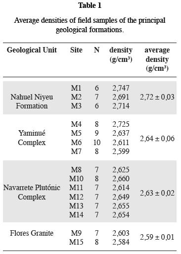
In the northeast region of NPM were surveyed 144 new gravimetric, magneto–metric, and topographic points (Fig. 1). The gravity values were obtained through use of a LaCoste & Romberg gravimeter, with a precision of ± 0.01 mGal. These gravimetric measurements were referred to IGS Net 1971 (International Gravity Standardization Net 1971; Morelli et al., 1974) and linked to the Miguelete base station, Buenos Aires Province, Argentina. The intensity values of the total magnetic field, in the area were surveyed using a proton magnetometer GEM–M19T. Daily corrections were derived from the magnetic observatory of Trelew, located some 300 km to the south. At each surveyed station, we determined the ellipsoidal height referred to WGS84 (World Geodesic System 1984), using two (2) simple frequency GPSs with sub–meter precision. In the field, GPS base equipment and other portable radio equipped GPS were available separated by a maximum of 20 km. Both sets of equipment were employed in a differential mode. We carried out density measurements through hand–sampling of the most representative lithographical outcrops in the area under study (Table 1). Each measurement recorded in this table consisted of an average of 6–10 individual samples outcropping in the same site. These sites are amply distributed in the area of interest.
Data processing of gravity
The lateral density variations in the crust may be identifying through gravimetric anomalies (Blakely, 1995). In calculating the complete Bouguer anomaly (CBA), the classic expression was employed (e.g. Hinze et al., 2005).

Where:
Go: Observed gravity
Gt: Theoretical gravity derived from the international gravity formula from 1971
FA: Free–air correction (–0.3086*h)
CB: Bouguer correction (0.1119*h)
CT: Topographic Correction
h: ellipsoidal height (meters)
For the topographical correction, two digital elevation models were utilized (DEM): 1) Local DEM with grid cell–size of 90 m, (Fig. 2a); 2) DEM regional DEM which was expanded in respect to the local DEM 167 km outwards, gridding of 250 m using 2.67 g/cm3 density values (Hinze, 2003). The method implemented combines the algorithms developed by Kane (1962) and Nagy (1966) obtained through a topographic gridding correction (Fig. 2b) which, by means of a sampling operation assigned the correction value to each gravimetric station. When compared to the topographic correction Fig (2b) and local DEM Fig (2a) we corroborated that the maximum corrections coincide with the maximum topographic gradients.
The anomaly values were gridded at a separation distance of 3 km applying the minimum curvature method (Briggs, 1974). A map of the Bouguer anomalies was prepared (Fig. 3), corresponding to the study zone.
The complete Bouguer anomaly map contains distinct gravimetric effects produced by the following: a) regional field, product of the anomalies in the lower crust and upper mantle, and b) residual field corresponding to the gravity anomalies associated to geological domains primarily located in the upper crust. To identify the residual gravity anomalies, it is essential to discount the regional gravimetric effect from the complete Bouguer anomaly map (Pacino and Introcaso, 1987; Blakely, 1995). The upward continuation method is one way to separate the effects. This consists in continuation the potential field to a determined height above the measured surface. In the continued potential field we attenuated the short wavelengths to the point which leaves the regional effect gravity field. Following this separation of anomalies method, we drew up analytical prolongation maps of the field potential at diverse heights: 25, 30, 35, and 40 km. Extracting the qualitative analysis from these maps, we opted for the upward continuation map with results taken at 35 km field potential height (Fig. 4), without existing significant differences when compared to other maps. In Fig (4), the isoanomalies grew negatively towards the NPM, the Patagonian Precordillera and Septentrional Patagonian Cordillera. These negative maxima reflect the strong Patagonian horizontal component of the gravimetric effect of the Andean root. Towards the east, the isoanomalies increase reaching the value of 0 mGal in the Colorado Basin. This increase is coherent with the positive effect which produces a decrease in the continental crust thickness towards the Atlantic Coast.
By removing the regional field from the complete Bouguer anomaly map, we obtained a Bouguer residual anomaly map, (Fig. 5).
Processing the magnetic data
The IGRF was removed from the total magnetic intensity field map to the measurement date (Blakely, 1995) obtaining the magnetic anomalies of the upper crust.
To correlate the gravimetric and magnetic signals a priori, we executed a reduction to the pole of the magnetic anomalies (Baranov, 1957). This technique enabled us to transform the magnetic intensity anomalies, by assuming only the induced field and considering that the field is anomalous to the magnetic signal situated over the body causing the anomaly as in the gravimetric field.
Relationship between gravity and magnetic fields
Following the methods used by Hagiwara (1980), the gravity potential U at a point P (x, y, z) due to an anomalous body v with the density contrast Δρ has the expression.
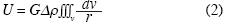
Where G is Newton's gravitational constant and r the distance between the attracted point P and a mass element Δρdv. For simplicity, Δρ is assumed to be constant.
The magnetic potential is written as

Where J is the magnetization vector assuming that the direction and magnitude of J are the same in all magnetized bodies.
Combination of (2) and (3) gives the Poisson relation:
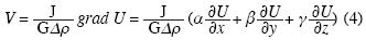
Where  , and α, Β and γ are direction cosines of J. This equation indicates that the magnetic potential can be calculated from the gravity potential. It should be noted here that, according to the convention of geomagnetism, the directions of x, y and z are taken northward, eastward and downward, respectively. Denoting the declination and the dip angle of J by D and I respectively, we have
α = cos I cos D, Β = cos I sin D, γ = sin I and that α2 + Β2 + γ2 = 1
To apply the Poisson relation Eq. (4) in the study area, we obtained the vertical gradient of the gravity map (Fig. 7) from the Bouguer residual anomaly map (Fig. 5). This map, from the Poisson relation should be equivalent to a hypothetical vertical magnetic density map. This expresses the degree of magnetization of the NPC and is compatible with the map of residual magnetic anomalies reduced at the poles (Fig. 6). Finally, the curves on profile A–A' were obtained from the vertical gravity gradient derived from the gravity and the magnetic signal reduced at the poles (Fig. 8).
The magnetization vs. density relation
To corroborate the differences in the rocks composing both plutonic complexes compute the relation  along the A–A' profile (Fig. 9), using the (Eq. 4). The curve shows negative values for the Western NPC and positive values for the Eastern NPC. This change of signals towards the east expresses that the densities of magnetization in both plutonic bodies are of opposing signals.
The lack of unity between both fields exposed in the Western NPC could be caused by a reverse remanent magnetization in the southern sector (Fig. 6) and a probable Koenigsberger factor (Q) > 1 (Rapalini et al., 2010). On the contrary, the measurements of magnetic susceptibility in the Eastern NPC indicate association with ferromagnetic rocks (Rapalini et al., 2010). This could be interpreted by normal remanent magnetization or by a factor Q <1. This would confirm the existence of significant differences between the outcropping rocks in the Western and Eastern NPC.
Complementary
calculations Signal analysis:
To determine the location of the borders between different geological units cut by profile A–A', (Fig. 10a), we calculated the horizontal derivative of gravity (Blakely, 1995) from the Bouguer residual anomaly map (Fig. 10b). Afterwards by using the vertical and horizontal gravity derivatives, we obtained the solutions of the analytic 2–D signal (Nabighian, 1972) (Fig. 10c). The principle inflections in the horizontal derivative curve Fig (10b) denote abrupt changes in the density of the rocks which argue that the basement is more superficial. In the study area, the sedimentary cover is thin, which allowed us to recognize in the field, the contacts between the different outcropping structures. To obtain the solutions of the analytic signal, it is necessary to establish the width of the mobile window and the depth of investigation. To determine the window width, we considered the wave lengths of the most important anomalies in the area. Likewise, we experimented by probing with several distances to determine the sensibility of the method discovering that at a distance of 10 km, the clusters of solutions respond well to the structures of interest. Distances greater than 10 km respond to the more regional structures, whereas this interpretation was difficult where distances were less than 10 km.
Gravity model
To quantify the relation between the gravimetric signal and the structure linked to the basement, we created a density model for the upper crust over the profile A–A', (Fig. 11).
The software implemented is based on the SAKI program, based on the Talwani method (Talwani et al., 1959) and those which utilize the algorithm proposed by Marquardt (1963).The geological information employed as initial data was primarily extracted from the work of LLambías et al. (2002) and Rapalini et al. (2008). The density values assigned to each geological unit are shown in Table I. These density values obtained indicate that the Nahuel Niyeu Formation wall rock of the Yaminué Complex and that of the NPC (LLambías et al., 2002; Rapalini et al., 2008) is the unit with greatest density (2.72 g/cm3). Both the Yaminué Complex and the NPC contain average densities similar to 2.64 g/cm3, consistent with an average granodiorite–type composition. Nevertheless, we could observe a much greater dispersion of values in the first of the complexes due to the major lithological variation.
Results
In general terms, these results manifest a correlation between the gravimetric residual anomaly map and the density of distinct outcropping units in the area of study, excepting those rocks exposed in the Yaminué Complex. The presence of maximum and minimum values of the gravimetric residual anomaly leads us to infer that the gravimetric signal obtained expresses the presence of diverse crustal levels exposed to the area under study. The Western NPC is located on a positive gravity anomaly towards the west of the NPC and has values between 5 – 10 mGal. On the contrary, the outcrops of the Eastern NPC are inserted in a region of maximum gravity anomaly value of –5 mGal.
The Bouguer residual anomaly map (Fig. 5) suggests that the western sector exposes deeper and denser crustal levels. Therefore, the maximum anomalies are located to the west of the Western NPC over the extensive outcrops of Yaminué Complex, whose deformation degree indicates crustal levels which are deeper. The deformation patterns observed in the Cabeza de Vaca Unit of the Western NPC (e.g. López de Luchi et al., 2007; Rapalini et al., 2007, 2010) are co–linear and coplanar, compared with those observed in the Yaminué Complex. These findings suggest a shared deformative history by both complexes corresponding to this unit of the shallower Western NPC structural level and a contemporary deformation with the intrusion.
The intrusion of the Eastern NPC in an area of minimal gravity field is consistent with previous shallower crustal levels which could have intruded this body without being seriously affected by the previous deforming event itself. The gravimetric data is consistent with the interpretation of those levels exposed in this intrusive being shallower that those in the Western NPC outcrops. Rapalini et al. (2010) had reported thermo–barometric data from both plutons which confirm this interpretation.
The outcrops of the Eastern NPC sector reveal positive values, whereas, the southern Western NPC sector is characterized by negative values. By comparing the magnetic anomalies reduced at the pole maps with the vertical gravity gradient (Poisson relation), we observed that both are inconsistent, the field polarization being inconsistent. This is especially notable in the Western NPC, even more than in the Eastern NPC region.
To better distinguish the differences between both signals they are illustrated along A–A' profile (Fig. 8). The lack of correlation between both fields indicates a change in the polarity of the anomalies caused by the granite bodies of the NPC.
The Bouguer residual anomaly map could be interpreted as an indicator of the presence of the two areas exposing deep structural levels of the Yaminué Complex (to the west) and in the immediate vicinity of Valcheta locality (to the east) separated by an area of deeper levels to the South Nahuel Niyeu (central sector).
The pocket of solutions of the analytical solutions of the analytical signal along the A–A' profile, are interpreted as contacts or faults which border the Yaminué Complex and NPC. These solutions reach approximate depths of 12 km. Towards the center of the low–profile riverbed of the Treneta stream, there is an abrupt change in the horizontal gradient curve (Fig. 10) giving evidence of an important fault which separates the Western and Eastern NPC blocks.
Figure 11 reveals a gravimetric model in the NW – SE direction. This fault divides the Plutonic Complex into two blocks, characterized by a significant difference in the basement depth. The west of the profile is shallower justifying the gravimetric maximum on the Yaminué Complex outcropping. In the eastern sector of the NPC Profile (density 2.63 g/cm3) the increase in depth reaches 12 km.
Conclusions
The application of the Poisson relation reveals lack of unity between the magnetic and gravimetric potential in the rocks of the NPC. This result is consistent with the change of polarity in the J/Aq relation and the Koenigsberger factor reported by other authors, which suggests a sample of reverse remanent magnetization in the western outcropping and normal remanent magnetization in the eastern outcropping. This difference in the Poisson relation between both sides of the Treneta stream would indicate that the blocks which make up the Navarrete Plutonic Complex would have had distinct periods of exhumation. This could be associated with compressive forces, as evidenced by a fault coinciding with the Treneta stream. The gravimetric model signals an elevated basement in the western sector of the Treneta River riverbed, leaving this fault solidly located by means of horizontal gradient techniques and analytic signal.
Acknowledgements
The authors would like to express their gratitude to the National Agency for Scientific and Technological Promotion for the subsidy granted PICT07 1903; as well as to CICITCA–UNSJ for their projects N° E816, N° E815, and N° E810 and to CONICET of Argentina (National Council for Scientific and Technological Promotion) whose financial support made the field work and surveys possible.
Bibliography
Baranov, V., 1957. Potential field and their transformations in applied geophysics. Gerbiinder Bonntraeger, Berlin, 121 pp. [ Links ]
Basei, M. A. S., R. Varela, A. M. Sato, JR. O. Siga and E. J. LLambías, 2002. Geocronología sobre rocas del Complejo Yaminué, Macizo Nordpatagónico, Río Negro, Argentina. XV Congreso Geológico Argentino, El Calafate. Actas en CD. [ Links ]
Blakely, R., 1995. Potential theory in gravity and magnetic applications. Cambridge University Press. [ Links ]
Briggs, I. C., 1974. Machine contouring using minimum curvature. Geophysics, 39, 1,39–8. [ Links ]
Chandler, V. W., J. S. Koski, W. J. Hinze and L. W. Braile, 1981. Analysis of multi source gravity and magnetic anomaly data set by moving–window application of Poisson's theorem. Geophysics, 46, 30–39. [ Links ]
Chernicoff, C. J. and R. Caminos, 1996. Estructura y relaciones estratigráficas de la Formación Nahuel Niyeu, Macizo Nordpatagónico oriental, Provincia de Río Negro. Revista de la Asociación Geológica Argentina, 51, 3, 201–212. [ Links ]
Croce, F., F. Lince Klinger, M. E. Gimenez, M. P. Martinez and F. Ruiz, 2009. Estimación de profundidades del Complejo plutónico Navarrete mediante procesamiento gravimétrico. Revista Geoacta, 34, 1–8. [ Links ]
Cordell, L. and P. Taylor, 1971. Investigation of magnetization and density of a North Atlantic seamount using Piosson's theorem. Geophysics, 36, 919–937. [ Links ]
Hagiwara, Y., 1980. Pseudomagnetic Anomaly Derived from Gravity Observations in Central Japan. Bulletin of Earthquake. Research Institute, 55, 27–41. [ Links ]
Hinze, W. J., 2003. Bouguer reduction density — Why 2.67?. Geophysics, 68, 5, 1559–1560. [ Links ]
Hinze, W. J., C. Aiken, J. Brozena, B. Coakley, D. Dater, G. Flanagan, R. Forsberg, T. Hildenbrand, G. R. Keller, J. Kellogg, R. Kucks, X. Li, A. Mainville, R. Morin, M. Pilkington, D. Plouff, D. Ravat, D. Roman, J. Urrutia–Fucugauchi, M. V'eronneau, M. Webring and D. Winester, 2005. New standards for reducing gravity data: The North American gravity database. Geophysics, 70, 4, 125–132. [ Links ]
Kane, M. F., 1962. A Comprehensive System of Terrain Corrections Using a Digital Computer. Geophysics, 27, 4, 455–462. [ Links ]
Lince Klinger, F., F. Croce, M. E. Gimenez and P. M. Martinez, 2008. Delimitación de cuerpos plutónicos, en el sector nororiental del macizo Norpatagónico, a partir de datos gravimétricos. XVII Congreso Geológico Argentino. Jujuy. Actas III, 1096–1097. [ Links ]
Lince Klinger, F., P. M. Martinez, M. E. Gimenez and E. A. Rapalini, 2009. Nuevas evidencias sobre el bajo espesor del Complejo Yaminué. Valcheta. Provincia de Río Negro. Actas de la XXIV Reunión Científica de la A. A. G. G. Mendoza. [ Links ]
Lince Klinger, F., P. M. Martinez, E. A. Rapalini, M. E. Gimenez, M. G. López de Luchi, F. A. Croce and F. Ruiz, 2010. Modelo gravimétrico en el borde noreste del Macizo Norpatagónico. Revista Brasilera de Geofísica, 28, 3. [ Links ] En prensa.
López de Luchi, M. G., A. E. Rapalini, R. Tomezzoli, 2007. The Late Paleozoic Navarrete Complex, NE North Patagonian Massif, Argentina: geology, chemical characterization and magnetic fabric study, Sixth Hutton Symposium on the Origin of Granites and related rocks, Stellenbosch, South Africa Abstract volume and Program Guide, 120–121. [ Links ]
López de Luchi, M. G., K. Wemmer and A. E. Rapalini, 2008. The cooling history of the North Patagonian Massif: first results for the granitoids of the Valcheta area, Río Negro, Argentina (Linares, E., Cabaleri, N. G., Do Campo, M. D., Ducós, E. I., Panarello, H. O., eds.) Book of Abstracts, VI South American Symposium on Isotope Geology, San Carlos de Bariloche, Abstracts, 33. [ Links ]
Llambías, E. J. and C. W. Rapela, 1984. Geología de los Complejos Eruptivos de La Esperanza, provincia de Río Negro. Revista de la Asociación Geológica Argentina, 39, 3–4, 220–243. [ Links ]
Llambías, E. J., R. Varela, M. Basei and A. M. Sato, 2002. Deformación y metamorfismo Neopaleozoico en aminué, Macizo Norpatagónico (40°50'S,67°40'W): su relación con la Fase Orogénica San Rafael y el arco de los Gondwánides. Actas XV Congreso Geológico Argentino, 3, 123–128. Buenos Aires. [ Links ]
Marquardt, D. W., 1963. An algorithm for least–squares estimation of non–linear parameters, J. SI AM, 11, 431–441. [ Links ]
Morelli, C., C. Gantar, T. Honkasalon, K. MCconnel, J. G. Tanner, B. Szabo, U. Uotila and C. T. Whalen, 1974. The International Standardization Net 1971 (IGSN71), IUGG–IAG Publ. Spec. 4, Int. Union of Geod. And Geophys., Paris. [ Links ]
Nabighian, M. N., 1972. The analytic signal of two–dimentional magnetic bodies with polygonal cross–secction: its properties and use for automated interpretation. Geophysics, 37, 780–786. [ Links ]
Nagy, D., 1966. The Gravitational Attraction of a Right Rectangular Prism. Geophysics, 30, 4, 362–371. [ Links ]
Pacino, M. C. and A. Introcaso, 1987. Regional anomaly determination using the upwards–continuation method. Boll. Geofis.Teor. Appl., XXIX,114, 113–122. [ Links ]
Pankhurst, R. J., C. W. Rapela, C. M. Fanning and M. Márquez, 2006. Gondwanide continental collision and the origin of Patagonia. Earth–Science Reviews, 76, 3–4, 235–257. [ Links ]
Rapalini, A. E., M. López de Luchi, R. Tomezzoli, F. Lince Klinger, M. Gimenez, P. Martinez, 2007. Magnetic fabric of the plutonic Navarrete Complex: further evidence for a Late Paleozoic collisional event in Northern Patagonia?. Actas GEOSUR, Santiago, Chile. [ Links ]
Rapalini, A. E., M. López de Luchi, F. Croce, F. Lince Klinger, R. Tomezzoli, and M. Gimenez, 2008. Estudio geofísico del Complejo Plutónico Navarrete: implicancias para la evolución tectónica de Patagonia en el Paleozoico Tardío. Actas V Simposio Argentino del Paleozoico Superior, Muse Arg. Ciencias Naturales, Bs. As., Resumenes, 34. [ Links ]
Rapalini, A. E., M. López de Luchi, C. Martinez Dopico, F. Lince Klinger, M. Gimenez, P. Martinez, 2010. Did Patagonia collide against Gondwana in the Late Paleozoic? Some insights from a multidisciplinary study of magmatic units of the North Patagonian Massif. Geológica Acta, 8, 4. En prensa. [ Links ]
Robinson, E. S., 1971. The use of Poisson's relation for the extraction of pseudototal magnetic field intensity from gravity observations, Geophysics, 36, 605–608. [ Links ]
Talwani, M., J. L. Worzel and M. Landisman, 1959. Rapid gravity computations for two dimensional bodies with application to the Mendocino Submarine Fracture zone. Journal of Geophysical Research, 64, 1, 49–58. [ Links ]

