


 nueva página del texto (beta)
 Inglés (pdf)
 Artículo en XML
 Referencias del artículo
 Enviar artículo por email
 Citado por SciELO
  Similares en
SciELO
Similares en
SciELO 
 Permalink
INTRODUCTION
Natural protected areas (NPA) are key for in situ conservation. According to Mexico’s environmental and conservation policy, mining and other extractive industries are subject to greater restrictions than activities involving renewable resource use (LGEEPA art. 47 bis). However, when certain NPAs are established in areas including important mineral deposits or where mines are in operation, ad hoc zoning and design adaptations have been implemented to favor mining interests.
Mining within NPAs has been often highlighted as one of several issues affecting protected areas in Mexico (e.g.,Bezaury-Creel & Gutiérrez Carbonell, 2009) and elsewhere in Latin America (e.g., Granizo, 2011). In recent academic literature, the confluence of mining and conservation in Mexico often emerges in studies on conflicts between local communities and mining corporations (Boni, Garibay & McCall, 2015; Tetrault, 2015); similar cases occur in other regions of Latin America (e.g., the Yasuní National Park in Ecuador; Finer, Vijay, Ponce et al. 2009). This fact not only underlines the relevance of this issue but also reveals the need to adopt a broader perspective beyond those cases made visible by the emergence of conflicts, shifting the focus on the underlying policies.
Very few approaches have addressed the scope and extent of mining in natural protected areas in Mexico. A first resource for assessing the spatial overlap between mining and natural protected areas can be found in GeoInfoMex, a geographic information site operated by the Mexican Geological Service (SGM, 2016a). This is a web-based map where the user can visualize, among mostly geological data, all natural protected areas of Mexico and superimpose layers representing mineral deposits, mines, major mining operations, etc. This information, however, is neither updated nor comprehensive (and is not downloadable), but nonetheless serves as a valuable starting point for the present work.
Another recent approach was adopted by Armendáriz et al. (2015), who estimated the overlap between areas of metallic-mining concessions and natural protected areas. This work reports that 7.9% of the total surface area of 175 FNPAs is granted to metallic mining. The fact that these areas are licensed by the federal government are indirect indicators of mining potential, but not necessarily of mining activity.
Although this information is useful, little can be inferred from it on whether or how this potential is materialized: mining licenses or concessions are needed from the earliest stages of direct mineral exploration, so a large proportion of licensed land may never be subject to mineral exploitation. In addition, there is a whole class of minerals that do not require a concession (such as sand, gravel, dimension stone, etc.) for exploitation.
A critical aspect is that such assessments do not take into account the scale and type of operation of each mine, both of which are directly related to its environmental impacts. The most pervasive and permanent environmental impacts derived from mining involve 1) changes in land cover and landforms; 2) water over-extraction; 3) soil pollution; and 4) surface and groundwater pollution. Mine size, mineral composition, and mineral extraction and beneficiation techniques are all factors that affect the types of potential impacts. For example, large-scale mines will naturally involve significant use of water and land relative to smaller-scale operations. Particularly, high-tonnage low-grade deposits will require surface or open-pit mining techniques due to the low concentrations of minerals, with impacts (land and water use, potential pollution, etc.) are more significant than those of most underground operations (Mudd, 2007). The type of minerals involved should also be considered, even in a primary assessment such as this, since different mineral types require different techniques (and chemicals) for post-extraction processing: while a metallic mineral open-pit mine may require in situ heap leaching techniques involving the use of cyanide and high volumes of water in addition to extensive land for the disposal of potentially pollutant wastes, surface mining of non-metallic minerals (such as gypsum) is far less intensive in the use of chemicals, although its impacts on landscape may still be considerable. Lower down on this spectrum is salt extraction, which may be considered as minimally disruptive. Our findings show that mining within FNPAs in Mexico covers a large variety of mines in all these aspects, ranging from artisanal sea salt and riverbed sediment extraction to large-scale open-pit metallic and non-metallic extraction.
This paper provides an overview of the mining activities currently taking place within natural protected areas managed by the federal government (FNPA) that have granted permission to conduct mining activities, aiming to highlight this as a relevant land-use policy issue. First, we focus on a general survey and characterization of the current state of mining activities within FNPAs, and then describe and discuss the ways in which mining is granted through ad-hoc zoning schemes and management programs. We aim to show that mining operations are common within FNPAs, and that the ways mining is incorporated as elements of zoning schemes and management programs are at times in conflict with conservation goals. More specifically, the questions guiding this research were to determine: 1) the spatial extent/distribution of mining activities within FNPAs in Mexico; 2) types of current mining activities within these FNPAs in terms of scale of operation, mineral type, and operation status; and 3) the role of zoning in regard to mining in NPAs.
MINING CONCESSIONS WITHIN FNPAS
The provisions that regulate mining operations within a natural protected area stem from the General Law for Ecological Balance and Environmental Protection (LGEEPA, Ley General del Equilibrio Ecológico y la Protección al Ambiente) and its regulations for natural protected areas (RANP, Reglamento de la Ley General del Equilibrio Ecológico y la Protección al Ambiente en Materia de Áreas Naturales Protegidas). These guidelines are put in practice when the zoning scheme and management program for each individual NPA area designed.
The establishment and management of natural protected areas in Mexico are mainly a federal matter. Although state and municipal NPAs do exist, they represent a minor area and are ultimately bound by federal laws and regulations. The National Commission for Natural Protected Areas (CONANP, Comisión Nacional de Áreas Naturales Protegidas) is the federal agency directly responsible for managing and establishing new natural protected areas; this agency belongs to the Secretariat for the Environment and Natural Resources (SEMARNAT, Secretaría del Medio Ambiente y Recursos Naturales). CONANP also publishes all official statistics, cartographic information, and management programs for all federal natural protected areas.
Under the current framework, mining may only be conducted in specific categories of natural protected areas. When an area is designated as an FNPA by presidential decree, it is classified under one of six categories, namely sanctuaries, national parks, natural monuments, natural resource protection areas, flora and fauna protection areas, and biosphere reserves (LGEEPA, art. 46). Only the last three categories, i.e., biosphere reserves (BR), flora and fauna protection areas (FFPA), and natural resource protection areas (NRPA), may include mining as a permitted activity in their management programs (LGEEPA, art. 46, 47 bis, 47 bis 1). There are currently 41 BRs, 39 FFPAs, and 8 NRPAs (CONANP, 2016a).
For mining to be acknowledged as a granted activity, it must be expressly stated as such in the respective management program. When an NPA is established, the decree includes only broad guidelines and general zoning (into core and buffer zones). Once the NPA is enacted, CONANP must put together a management program detailing its guiding rules and principles, as well as a detailed zoning scheme in which core and buffer zones are further divided into subzones (LGEEPA, art. 65; RANP, art. 74 and 75). For the preparation of an NPA, SEMARNAT seeks the assistance of local communities and landowners, state and municipal governments, other government agencies, and non-governmental institutions (LGEEPA, art. 65). The zoning unit where mining is allowed within an NPA is the special-use subzone. A resolution on whether or not mining is granted within a specific NPA can be issued only after the subzoning process is completed.
The granting of mining within a management program is a pre-requisite, although it does not warrant that mining operations will proceed. Although other permits must be obtained, the primary restraint of mining within an NPA is its expressed prohibition in a management program. Identifying NPAs in which mining is permited in their management programs thus provides vital information for understanding the interaction between conservation and extractive industries, and how conservation policy is defined and applied in Mexico.
MATERIALS AND METHODS
For our first objective, i.e., to survey the spatial extent/distribution and type of mining granted within FNPAs in Mexico, we defined the set of protected areas that may allow mining in their management programs considering their respective categories, namely biosphere reserves, fauna and flora protection areas, and natural resource protection areas; these were selected from a natural protected area handbook published by CONANP (2016a). We then selected those NPAs that have a management program available in the CONANP website (CONANP, 2016b). We finally selected the subset of NPAs for which mining is expressly granted in their respective management programs, as well as other relevant data regarding mining therein.
To complete the survey, we resorted to diverse sources that allowed the identification and classification of mining activities within individual FNPAs. Our starting point was the Mexican Geological Survey GeoInfoMex database (SGM, 2016a), but all mining project data reported were further supported and expanded through other sources, mainly company documents and websites, in addition to government licenses and other publications. Mining activity was classified in terms of mineral type (metallic/non-metallic), operation status (exploration, planned projects, active operations), and scale and mode of operation (open-pit/ underground, large-scale/small-scale, etc.)
For the discussion regarding special-use subzones, we based our analysis on NPA zoning schemes in vector format available through the CONANP geographic data repository (CONANP, 2016c). We applied standard statistical and spatial analyses regarding the extent of these zones, as well as their spatial relationships with geological and other environmental features relevant to the selected cases.
A SURVEY OF MINING IN FNPAS IN MEXICO
FNPAs where Mining is Granted
Our survey of FNPAs where mining is granted considered a total of 177 federal natural protected areas (CONANP, 2016a). Of these, only those designated as biosphere reserves (BR), flora and fauna protection areas (FFPA), or natural resource protection areas (NRPA) may include mining as an allowed activity in their management programs (LGEEPA, art. 47 bis 1). There are currently 41 biosphere reserves, 39 flora and fauna protection areas, and 8 natural resource protection areas. Not all of them have a management program - only 38 BRs and 26 FFPAs have this document (CONANP, 2016b). Of these, 18 BRs and 12 FFPAs expressly allow mining in their management programs and were thus considered in the survey (Table 1).
Table 1 Federal natural protected areas that allow mining in their management programs. The numbers on the left correspond to those in Figure 1.
| Name | State | Category | Mineral deposits, projects or
operations considered in the management program |
|
| 1 | Alto Golfo de California y Delta del Río Colorado | Baja California, Sonora | BR | sea salt extraction |
| 2 | Valle de los Cirios | Baja California | FFPA | high-tonnage low-grade copper-gold deposit |
| 3 | El Vizcaíno | Baja California Sur | BR | coastal salt works (large scale) gypsum mine (large-scale) copper-cobalt open-pit mine project |
| 4 | Isla San Pedro Mártir | Sonora | BR | unspecified |
| 5 | Islas del Golfo de California | Baja
California, Baja California Sur, Sonora, Sinaloa |
FFPA | gypsum mine (large scale) |
| 6 | Sierra La Laguna | Baja California Sur | BR | open-pit gold mine project |
| 7 | Janos | Chihuahua | BR | poly-metallic and manganese deposits |
| 8 | Médanos de Samalayuca | Chihuahua | FFPA | limestone and gypsum copper deposits and small mines |
| 9 | Tutuaca | Chihuahua | FFPA | open-pit and underground gold-silver mines and further exploration |
| 10 | Sierra de Álamos-Río Cuchujaqui | Sonora | FFPA | high-grade silver deposits |
| 11 | Meseta de Cacaxtla | Sinaloa | FFPA | opal deposits gold-silver deposits |
| 12 | Mapimí | Durango | BR | limestone quarries small-scale brine-wells (common salt) |
| 13 | Ocampo | Coahuila | FFPA | flagstone quarries (piedra laja) fluorite deposits |
| 14 | Cuatrociénegas | Coahuila | FFPA | sodium/magnesium sulfate brine-wells gypsum deposits |
| 15 | Sierra la Mojonera | San Luis
Potosí, Zacatecas |
FFPA | onyx (banded calcite) quarry |
| 16 | Laguna Madre y Delta del Río Bravo | Tamaulipas | FFPA | coastal salt works |
| 17 | Islas Marias | Nayarit | BR | Sea salt extraction (small scale) |
| 18 | Marismas Nacionales Nayarit | Nayarit | BR | unspecified |
| 19 | La Primavera | Jalisco | FFPA | unspecified |
| 20 | Sierra Gorda de Guanajuato | Guanajuato | BR | fluorite mine poly-metallic deposits |
| 21 | Sierra Gorda | Querétaro | BR | limestone quarries |
| 22 | Barranca de Metztitlán | Hidalgo | BR | sand and gravel extraction for local construction |
| 23 | Zicuirán-Infiernillo | Michoacán | BR | copper and iron deposits and inactive mines |
| 24 | Mariposa Monarca | Michoacán | BR | underground silver mine reactivation project |
| 25 | Sierra de Huautla | Morelos | BR | limestone quarries silver-lead deposits and inactive mines |
| 26 | Tehuacán-Cuicatlán | Oaxaca, Puebla | BR | limestone and onyx (banded calcite) quarries common salt brine-wells |
| 27 | Los Tuxtlas | Veracruz | BR | poly-metallic deposits |
| 28 | Cañón del Usumacinta | Tabasco | FFPA | inactive limestone quarry |
| 29 | Ría Celestún | Campeche, Yucatán | BR | “artisanal” coastal salt extraction |
| 30 | Ría Lagartos | Yucatán | BR | coastal salt works (large-scale) |
These 30 NPAs were first characterized regarding the prevalence of mineral deposits in terms of mineral type and size. FNPAs where mining is allowed encompass a wide variety of mineral deposit types. These fall into four major categories: 1) metallic minerals, such as gold, silver, copper, and zinc; 2) non-metallic minerals subject to concession (except common salt), such as fluorite, gypsum, and barite; 3) non-metallic minerals not subject to concession, mainly limestone, sand, and dimension and crushed stone; and 4) common salt, obtained from either coastal ponds or brine wells. Metallic mineral deposits are present in 17 of these FNPAs; non-metallic mineral deposits subject to concession, in 10; non-metallic mineral deposits not subject to concession, in 11; and common salt deposits, in 7 (Figure 1). The presence of these deposits does not imply the existence of actual mining operations, nor can the spatial extent or scale of operation be inferred from this information alone. The following subsections show the mining activities currently in operation in these 30 FNPAs in each of the categories just mentioned.
Figure 1 Mineral deposit types in FNPAs where mining is granted. Mineral deposit types included here but not in Table 1 were determined from geologic maps and other sources referred throughout the text.
Metallic Mining in FNPAs
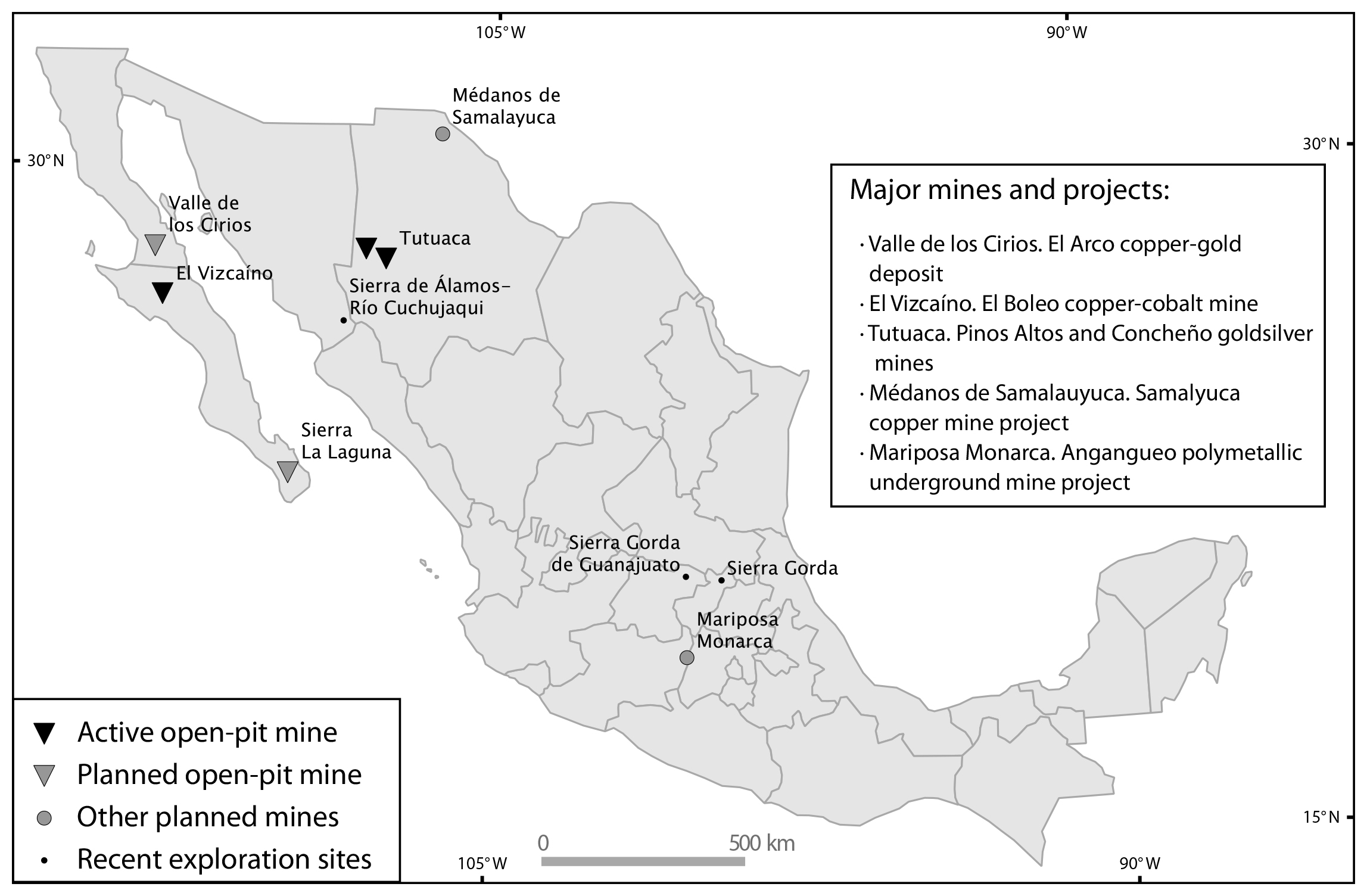
Major metallic mining operations currently take place in two FNPAs. Both are large-scale operations that involve open-pit mining techniques. In El Vizcaíno BR (established in 1988), the El Boleo project, owned by Korea Resources Corporation, is an underground and surface (strip-mining) copper-cobalt-zinc-manganese mine. It is located on the coast of the Sea of Cortez near the town of Santa Rosalía, state of South Baja California. The mine started operations in early 2015 and is currently active (KORES, 2016). It is planned to be in operation for about 20 years, with an average production rate of 7,000 tons per day. The main beneficiation process involves sulfuric acid leaching (Minera y Metalúrgica del Boleo, 2006).
The other FNPA with significant metallic mining activity is the Tutuaca FFPA (established in 1937 and reclassified in 2001), in the state of Chihuahua. Three gold-silver open-pit mines are currently active in the southern section of this area. The Canadian company Agnico-Eagle owns and operates the Pinos Altos & Creston-Mascota mines, whose production (5,000 ton/day) started operations in 2009 and 2011, respectively (Agnico-Eagle, 2016). The third mine currently in operation in this area is the Concheño mine (15,000 ton/ day), active since 2013 and presently owned by the Mexican company Minera Frisco (Minera Frisco, 2016). In all three operations, open-pit mining is the primary extraction method (the Pinos Altos and Concheño mines also include underground mining), and all involve cyanide heap leaching as part of their beneficiation processes. Besides, exploration efforts are ongoing in the area called Promontorio targeting similar high-tonnage low-grade gold-silver deposits (Azure Minerals, 2017).
The four mines mentioned above are the only major metallic mining operations currently active in FNPAs. However, other large projects are under development in other areas. In the Sierra de la Laguna BR (established in 1994), South Baja California, there is a well-defined project for a large-scale open-pit gold mine: the Los Cardones project, acquired by Invecture Group in 2013 (Vista Gold, 2013) in affiliation with the Canadian Frontera Mining Company. Public opposition to the mine (León, 2014a b) has prevented it from opening even after licenses from SEMARNAT were issued in 2014 (Leon, 2014a, b). Nonetheless, the company still includes it among its projects planned for development. The estimated production rate ranges between 11,000 and 15,000 ton/day and involves cyanide leaching as its main beneficiation process (Invecture Group, 2016a, b).
In the Valle de los Cirios FFPA (1980), in the state of Baja California, there is a copper-gold deposit known as El Arco, held in concession by the Mexican company Grupo Mexico. This is a high-tonnage low-grade deposit, i.e., its exploitation would depend primarily on open-pit methods. Though formally still in the exploration stage, its potential has been acknowledged since at least the 1980s (Terrones Lagone, 1986; Valencia-Moreno, Ochoa-Landín, Noguez-Alcántara et al, 2006), and in 2010 it was highlighted as a viable project by the Mexican government in a publication intended to attract foreign investment for the mining sector (Estrada Cortés, 2010).
Grupo Mexico also owns the comparatively smaller Angangueo project in the Mariposa Monarca BR (established in 1986). This project, originally planned to start operations in 2014 and holding most licenses since 2005 (Hernández, 2014), has also been delayed due to public opposition (Fagin, 2016). The project involves the expansion of a poly-metallic (silver, copper, lead, and zinc) underground mine with a planned production rate of 1,200 tons per day to be processed by flotation (Industrial Minera Mexico, 2005).
Another small-scale project planned for development and currently awaiting licensing is the Samalayuca Project, a copper deposit located within the Médanos de Samalayuca FFPA in the state of Chihuahua (Boily, 2013). As stated in its website, this company expected to begin a pilot mine construction in late 2016 (VVC Exploration, 2016). Again, opposition has restrained the original plans to start operation (Cortez, 2015; “Niega Semarnat permiso a mina en Samalayuca”, 2015).
Besides the cases mentioned above, we identified the following incidences of metallic mining activity within FNPAs according to licenses issued by SEMARNAT as listed in its public record database (SEMARNAT, 2016): two small-scale mercury and antimony extraction projects in the Sierra Gorda BR (state of Queretaro); two silver-gold exploration projects in the Sierra Gorda de Guanajuato BR; and one silver exploration project acknowledged in the management program for the Sierra de Álamos-Río Cuchujaqui FFPA (state of Sonora). License granting by SEMARNAT is not necessarily indicative of actual mining activity, but does point to the existence of specific metallic-mining targets within FNPAs.
In summary, three large-scale mining operations are currently active within FNPAs, all involving open-pit mining techniques, which started operations after the protected areas were established. Besides, there are four projects ready for development or pending licenses. Table 2 summarizes the major metallic mining projects within FNPAs (Figure 2).
Table 2 Major metallic mining projects in FNPAs. Reserves and production rates (tons of ore processed per day) are included as indicators of the scale of operation, as reported in the following sources: Pinos Altos & Crestón-Mascota (Agnico-Eagle, 2016); Concheño (Minera Frisco, 2016); El Boleo (Korea Resources, 2016); Los Cardones (Invecture Group, 2016a); El Arco (Valencia-Moreno et al, 2006); Angangueo (Industrial Minera Mexico, 2005); Samalayuca (VVC Exploration, 2016).
| NPA (state) | Mine/project | Metal | Status | Reserves | Production rate (tons/day) |
| Tutuaca
(Chihuahua) |
Pinos Altos &
Crestón-Mascota Concheño |
gold-silver
gold-silver |
Active since 2009
Active since 2013 |
1.5 million oz
(gold); 38 million oz (silver) unknown |
5,000
15,000 |
| El Vizcaíno (Baja California Sur) |
El Boleo | copper-cobalt | Active since 2016 | 1 million ton (copper); 40,000 ton (cobalt) |
7,000 |
| Sierra de la Laguna
(Baja California Sur) |
Los Cardones | gold | Permits pending | 1.2 million oz | 11,000 to 15,000 |
| Valle de los
Cirios (Baja California) |
El Arco | copper-gold | Permits pending | 3.6 million
ton (copper); 3.9 million oz (gold) |
- |
| Mariposa
Monarca (Michoacán) |
Angangueo | silver-zinc- copper-lead |
Permits pending | unknown | 1,200 |
| Médanos de Samalayuca (Chihuahua) |
Samalayuca | copper | Permits pending | 20,000 ton (copper) | - |
Non-Metallic Mining in FNPAs
Non-metallic minerals are subdivided into 1) minerals subject to concession, such as gypsum, fluorite, barite, etc.; 2) common salt; and 3) minerals not subject to concession, basically sand, gravel, limestone, etc. In regard to the first group, two large-scale gypsum mines are currently active within FNPAs. In the Islas del Golfo de California FFPA (established in 1963 and reclassified in 2000), Compañía Occidental Mexicana owns an open-pit gypsum mine in San Marcos island, off the coast of Santa Rosalía in South Baja California. This mine has been in operation since 1923 (SGM, 2008) and was therefore already active when the NPA was expanded in 1978 to include this and other Gulf islands. Not far from San Marcos island, on the mainland and within the El Vizcaíno BR (established in 1988), is the Punta Santa María gypsum mine. This mine has been active since 1970 (SGM, 2008) and is owned by the CAOPAS company. The combined annual production of the San Marcos and Santa María mines averaged over 3 million tons of gypsum in years 2014 and 2015, equivalent to over 55 % of the national output (SGM, 2016b). In both cases, mining activity was already active by the time the protected areas were established.
In addition to these two gypsum mines, permits (SEMARNAT, 2016) have been granted for trona (a form of hydrated sodium carbonate) extraction in the Alto Golfo y Delta del Río Colorado BR (license granted in 2010); barite extraction in the Valle de los Cirios FFPA (license granted in 2011); and fluorite exploration and rehabilitation of the processing plant in the Sierra Gorda de Guanajuato BR (licenses granted in 2013 and 2009, respectively).
Salt mining in FNPAs covers a broad range in terms of scale of operation. The Guerrero Negro salt works (in operation since 1957) in the El Vizcaíno BR, arguably the largest salt mine worldwide, is operated by a joint venture between the Mexican government and Mitsubishi Corporation (ESSA, 2016). Its annual output of over 8 million tons (SGM, 2016b) amounts to 85 % of all salt produced in the country and 3 % of world salt production (USGS, 2014). Salt is also produced industrially (although not at a scale comparable to that of Guerrero Negro) at Las Coloradas salt works (in operation since 1946) in the Ría Lagartos BR (established in 1979 and reclassified in 1999), in Yucatan, by Industria Salinera de Yucatán (Grupo Industrial Roche, 2016). Ranking third in terms of scale is Boladeña salt works (in operation since 1957) in the Laguna Madre y Delta del Río Bravo FFPA (established in 2005), with a much lower annual production of a few thousands of tons (Salinera La Boladeña, 2016). At the end of the spectrum, salt is extracted by artisanal methods from coastal ponds in the Ría Celestún BR and from brine wells in the Tehuacán-Cuicatlán BR, according to the respective management programs (CONANP, 2016b). Production rates for these sites have not been detailed in any official reports.
Regarding the last category -minerals not subject to concession (sand, gravel, limestone, etc.)- only a few known projects were identified, involving a small scale. These projects (Table 4) were identified through a public information request to SEMARNAT regarding non-metallic projects that had been recently filed for environmental authorization. The environmental impact assessments thus obtained provide relevant data regarding the kind of mining practices involved. Only seven projects were found, most of them regarding construction materials (sand, gravel, limestone, basalt, and cobblestone), operating over small areas (1 hectare to 23 hectares), and with low-to-medium production rates. Also in this category are limestone quarries in the Tehuacán-Cuicatlán BR and flagstone quarries (piedra laja) in the Ocampo FFPA, both referred to in the relevant management programs. All seven project were filed and approved after the establishment of the protected areas.
Table 3 Major non-metallic mines (minerals not subject to concession) in FNPA. Sources: Isla San Marcos and Punta Santa María (SGM, 2008, 2009); Guerrero Negro (SGM, 2016b); Las Coloradas (Grupo Industrial Roche, 2016); La Boladeña (Salinera La Boladeña, 2016).
| NPA (state) | Mine | Mineral | Status | Annual production (millions of tons) |
| Islas del Golfo de
California (Baja California, Baja California Sur, Sonora, Sinaloa) |
Isla San Marcos | gypsum | Active since 1923 | 2.5 (2007 data) |
| El Vizcaíno (Baja California Sur) | Punta Santa
María Guerrero Negro |
gypsum salt | Active since
1993 Active since 1957 |
0.7 (2007
data) 8.7 |
| Ría Lagartos (Yucatán) | Las Coloradas | salt | unknown | 0.75 |
| Laguna Madre y Delta del Río Bravo (Tamaulipas) |
La Boladeña | salt | Active since 1957 | 0.03 |
Table 4 Recently authorized non-metallic mining projects in natural protected areas in Mexico. Data were obtained from the SEMARNAT environmental authorizations online database (SEMARNAT, 2016).
| NPA (state) | Project description | Year of authorization |
| Valle de los
Cirios FFPA (Baja California) |
manual extraction of
beach cobbles (~3,500 ton/yr; area: ~23 ha) “onyx” (banded calcite) quarry (~3000 ton/month for 17 years; area: ~10 ha) |
2001 2014 |
| Sierra Gorda
BR (Querétaro) |
riverbed sediment
(sand and gravel) extraction (~4000 m3/yr; area: ~0.2
ha) limestone quarry (area: ~3 ha; ~5-year project) riverbed sediment (sand and gravel) extraction (~18,000 m3/yr; area: ~0.8 ha) |
2013 2015 2015 |
| Sierra de Huautla BR (Morelos) |
basalt quarry (140,000 m3/yr for 10 years; ~5.8 ha) | 2014 |
FNPAs with no mining
Seven of the FNPAs included in the initial set (Table 1) turned out to have neither mining operations nor mining projects within them. This group includes four FNPAs with no mining concessions: Isla San Pedro Mártir BR, Islas Marías BR, Cañón del Usumacinta FFPA, La Primavera FFPA (Armendáriz-Villegas, Covarrubuias-García, Troyo-Diéguez et al., 2015). In Marismas Nacionales Nayarit BR, Sierra la Mojonera FFPA, and Barranca de Metztitlán BR, no significant mining activity seems to exist according to the Mexican Geological Survey (SGM, 2016a), notwithstanding the existence of at least one concession in each of these protected areas.
In the cases where concessions are still held, it can be assumed that the designation of these areas as protected has discouraged mining companies from advancing or at least prioritizing their projects there. In the Islas Marias BR, mining is allowed in the management program for the unforeseeable reactivation of small-scale coastal salt ponds, although no active grant exists for this activity. In the case of the Isla San Pedro Mártir BR, the management program is somewhat vague as regards mining: it mentions guano extraction during the second half of the 19th century and allows mining in a marine area surrounding the island, without specifying the kind of mining that is expected to be carried out.
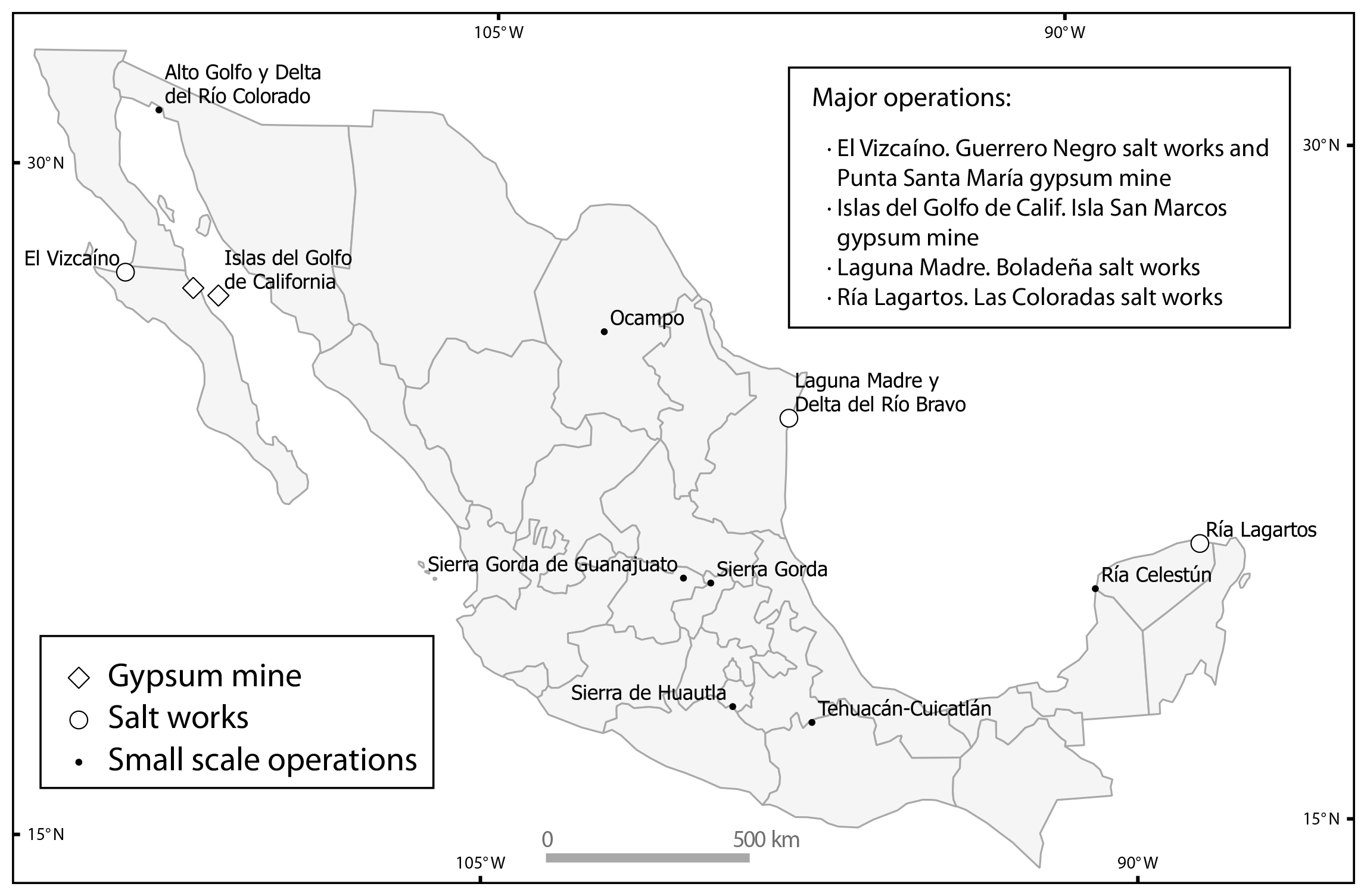
Figure 3 Major non-metallic mining operations and other smaller planned or active projects in FNPAs. See Table 3 and Table 4 for details.
Finally, the case of Barranca de Metztitlán stands out for the intention stated in the management program to ultimately discontinue all mining operations within the protected area. This was achieved by only allowing mining exploration projects for which permits were granted prior to the NPA designation.
SPECIAL-USE SUBZONES
Zones Allocated to Mining
Following UNESCO (1996), LGEEPA states that biosphere reserves and flora and fauna protection areas are to be zoned into core zones and buffer zones. These are further divided into various subzones. While core zones are subdivided into different but generally restrictive subzones for well-preserved ecosystems, buffer zones allow for a number of combinations of resources and land uses. Buffer zones are chiefly designed to allow human activities, ideally through sustainable practices. LGEEPA defines eight different subzones into which buffer zones may be subdivided. Most are intended for various forms of (sustainable) agriculture, livestock farming, forest use, etc. It also defines subzones for human settlements, public use/tourism, ecosystem recovery, and preservation (LGEEPA, art. 47 bis). A class in itself is the special-use subzone (SUSZ), where mining may be allowed.
SUSZs were first defined in federal regulations for natural protected areas in 2000 (RANP, art. 49) and then incorporated into the federal environmental law in 2005 (LGEEPA art. 47 bis). They are defined as follows:
Surfaces, generally of small extension, containing natural resources that are essential for social development, and which shall be exploited without deteriorating the ecosystem, modifying the landscape in any substantial manner, or causing an irreversible environmental impact on the related natural elements.
In these subzones, the only public or private works that may be conducted include the installation of infrastructure, the exploitation of natural resources that yield public benefits, maintain harmony with the landscape, do not cause severe ecological unbalance, and are subject to strict regulations for the sustainable use of natural resources (LGEEPA, art. 47 bis).
Although mining is not explicitly mentioned in this definition, the SUSZ is generally interpreted in management programs as the appropriate zoning unit for mining.1 Other zoning units are defined in ways that clearly state that mining of any sort shall not be conducted therein.
From the set of 30 FNPAs where mining operations are allowed, 21 do so through SUSZs (Table 5). In FNPAs established or zoned prior to the adoption of the SUSZ, mining was included as a permissible activity in other, generally much larger, zoning units such as sustainable use of natural resources subzone or other ad-hoc designations (e.g., El Vizcaíno BR, Sierra de Álamos-Río Cuchujaqui FFPA, and Sierra Gorda BR). A special case is the Ocampo FFPA which, although established after 2005, allows mining in zoning units other than the SUSZ.
Table 5 Zoning units for FNPAs where mining is permitted in management programs. The following abbreviations have been used (original Spanish in parenthesis): SUSZ: special-use subzone (subzona de aprovechamiento especial), SUNRZ: sustainable use of natural resources zone (zona de aprovechamiento sustentable de los recursos naturales), SUNRSZ: sustainable use of natural resources subzone (subzona de aprovechamiento sustentable de los recursos naturales), CUSZ: controlled-use subzone (subzona de aprovechamiento controlado), HSSZ: human settlement subzone (subzona de asentamientos humanos), MUSZ: moderate-use subzone (subzona de uso moderado), BZ: buffer zone (zona de amortiguamiento). As of 2005 (LGEEPA art. 47bis) mining may only be permitted in SUSZ. The numbers preceding NPA names refer to those in Figure 1.
| Natural protected area (state) | Year of publication of most recent decree/ management program |
Zoning unit where mining is allowed1 |
Area (hectares) where mining is allowed (% of total NPA) |
Total NPA area (hectares) |
| 1. Alto Golfo de California y Delta del Río Colorado (Baja California, Sonora) | 1993/2009 | SUSZ | 3,908 (0.4 %) | 934,756 |
| 2. Valle de los Cirios (Baja California) | 2000/2013 | SUSZ | 26,226 (1.0 %) | 2,521,988 |
| 3. El Vizcaíno (Baja California Sur) | 1988/2000 | SUNRZ | 1,163,229 (45.7 %) | 2,546,790 |
| 4. Isla San Pedro Mártir (Sonora) | 2002/2009 | SUNRSZ | 29,054 (39.9 %) | 72,911 |
| 5. Islas del Golfo de California (Baja California, Baja California Sur, Sonora, Sinaloa) | 2000/2001 | SUSZ | spatially undefined | ~300,000 |
| 6. Sierra de la Laguna (Baja California) | 1994/2003 | SUSZ | 2,209 (2.0 %) | 112,437 |
| 7. Janos (Chihuahua) | 2009/2012 | SUSZ | 1,562 (0.3 %) | 526,482 |
| 8. Médanos de Samalayuca (Chihuahua) | 2009/2013 | SUSZ | 828 (1.3 %) | 63,182 |
| 9. Tutuaca (Chihuahua) | 2001/2013 | SUSZ | 19,361 (4.4 %) | 436,986 |
| 10. Sierra de Álamos-Río Cuchujaqui (Sonora) | 1996/2015 | SUNRSZ | 72,947 (78.5 %) | 92,890 |
| 11. Meseta de Cacaxtla (Sinaloa) | 2000/2015 | SUSZ SUNRSZ | 322 (0.6 %) 2,000 (3.9 %) | 50,862 |
| 12. Mapimí (Durango) | 2000/2006 | SUSZ | 10,158 (3.0 %) | 342,388 |
| 13. Ocampo (Coahuila) | 2009/2015 | SUSZ SUNRSZ | 5,955 (1.7%) 277,962 (80.7 %) | 344,238 |
| 14. Cuatrociénegas (Coahuila) | 1994/2000 | CUSZ | 27,946 (33.1 %) | 84,327 |
| 15. Sierra la Mojonera (San Luis Potosí, Zacatecas) | 2000/2015 | SUSZ | 5 (0.1 %) | 9,272 |
| 16. Laguna Madre y Delta del Río Bravo (Tamaulipas) | 2005/2015 | SUSZ | 432 (0.1 %) | 572,809 |
| 17. Islas Marias (Nayarit) | 2000/ 2011 | SUSZ | 29 (< 0.1 %) | 641,285 |
| 18. Marismas Nacionales Nayarit (Nayarit) | 2010/2013 | SUSZ | 2,945 (2.2 %) | 133,854 |
| 19. La Primavera (Jalisco) | 2000/2001 | SUSZ | 464 (1.5 %) | 30,500 |
| 20. Sierra Gorda de Guanajuato (Guanajuato) | 2007/(proposal) | SUSZ | 8,298 (3.5 %) | 236,883 |
| 21. Sierra Gorda (Querétaro) | 1997/2000 | BZ | 358,764 (93.5 %) | 383,567 |
| 22. Barranca de Metztitlán (Hidalgo) | 2000/2003 | HSSZ | 472 (0.5 %) | 96,042 |
| 23. Zicuirán-Infiernillo (Michoacán) | 2007/2013 | SUSZ | 875 (0.3 %) | 265,118 |
| 24. Mariposa Monarca (Michoacán) | 2000/2001 | SUSZ | 57 (0.1 %) | 56,259 |
| 25. Sierra de Huautla (Morelos) | 1999/2007 | SUSZ | 1,183 (2.0 %) | 59,031 |
| 26. Tehuacán-Cuicatlán (Oaxaca, Puebla) | 1998/2012 | SUSZ | 222 (0.1 %) | 490,187 |
| 27. Los Tuxtlas (Veracruz) | 1998/2009 | SUSZ | 3,085 (2.0 %) | 155,122 |
| 28. Cañón del Usumacinta (Tabasco) | 2008/2015 | SUSZ | 22 (0.1 %) | 46,128 |
| 29. Ría Celestún (Campeche, Yucatán) | 2000/2002 | SUNRSZ | 42,131 (51.7 %) | 81,482 |
| 30. Ría Lagartos (Yucatán) | 1999/2000 | MUSZ | 2,461 (4.08 %) | 60,348 |
Surely, the aim of zoning schemes that allow mining in large zones or subzones other than SUSZs was not to license it across the entirety of these vast areas. These cases may be understood as resulting from what at the time were poorly defined zoning guidelines and criteria, and are no consistent with the more explicit terms of the special-use subzone. The same is not true for SUSZs. As the definition clearly states, SUSZs aim to restrict mining to small low-impact areas. In the following discussion, we review the ways SUSZs are applied in zoning schemes, contrasting with their definition and objectives.
Small-Extent Areas
The first noticeable aspect in the definition of SUSZs is that they shall “generally be generally small in extension.” The requirement of a small extension for SUSZs seemingly aims at limiting environmental impacts by relating size to the magnitude of impact. However, no standard for size is offered and no true relationship between area and impact can be established without considering mineral type, mining techniques, and local environmental factors. The above lays the foundations for the following general observations.
A first approximation regarding SUSZ size is to gauge its area relative to total NPA area. From the data in Table 5, the average FNPA area classified as SUSZ is 1.3%, ranging from 0.004% to 4.41%. Of course, the actual SUSZ size depends on the total extension of the protected area: while 4.4 % of the area of the Tutuaca FFPA zoned as SUSZ corresponds to 193 km², 1% of the much larger Valle de los Cirios FFPA area amounts to 226 km². A more focused approach consists in examining individual polygons designated as SUSZ. The 20 FNPAs with SUSZs include a total of 76 individual polygons. The size of individual SUSZ polygons is extremely variable, ranging from 1 hectare to 26,226 hectares, with a mean value of 1,154 hectares and a median of 103 hectares.
The disparity in size indeed reflects the variety of mining types and scales described in the previous section, but also indicates a very flexible understanding of how small these zones should be. Particularly, the size of a given SUSZ seems to fulfill the requirements of a mining project or the extension of a mining license, rather than addressing the need to limit the impacts on landscape and ecosystems. Small zones are established for mines or deposits that are intrinsically small, while large ones are established for larger operations or projects. The following examples illustrate this relationship.
The smallest SUSZs are found in the Tehuacán-Cuicatlán BR. These one-to-two-hectare areas were established in order to allow small-scale salt extraction from brine wells. In this case, not only is the extension undoubtedly small, but also the related impacts are low and well-contained within the zone limits (water is pumped and evaporated in small terraced ponds; salt is collected by shovel).
Other SUSZs on the small side of the spectrum (below the median of 103 ha) include similar low-impact operations, generally involving non-metallic minerals: limestone quarries also in the Tehaucán-Cuicatlán BR (2 ha and 22 ha); flagstone quarries in the Ocampo FFPA (92 ha); basalt and limestone quarries in the Sierra de Huautla BR (15 ha), and coastal salt ponds in the Alto Golfo de California y Delta del Río Colorado FFPA (66 ha).
Other cases of small SUSZs involve metallic mining, most notably the Mariposa Monarca BR. In this area, the buffer zone is conspicuously dotted by ten special-use subzones with circular or semicircular areas ranging from 2 ha to 6.7 ha (Figure 4). These subzones were defined for the reactivation of the Angangueo silver mines. These SUSZs are located in areas required for mine access, mineral waste disposal, and mineral processing. Impacts from the mine, however, will not be constrained to these polygons. The actual mine extends well beyond the SUSZs, as it follows the vein-shaped deposits. In addition, considering that the mine will require continuous groundwater extraction as it progresses deeper down into the ground, water systems may also be affected. The two aquifers located within the SUSZ, Ciudad Hidalgo-Tuxpan (to the west) and Itxtlahuaca-Atlacomulco (to the east) are already overexploited (CONAGUA, 2015a, 2015b).
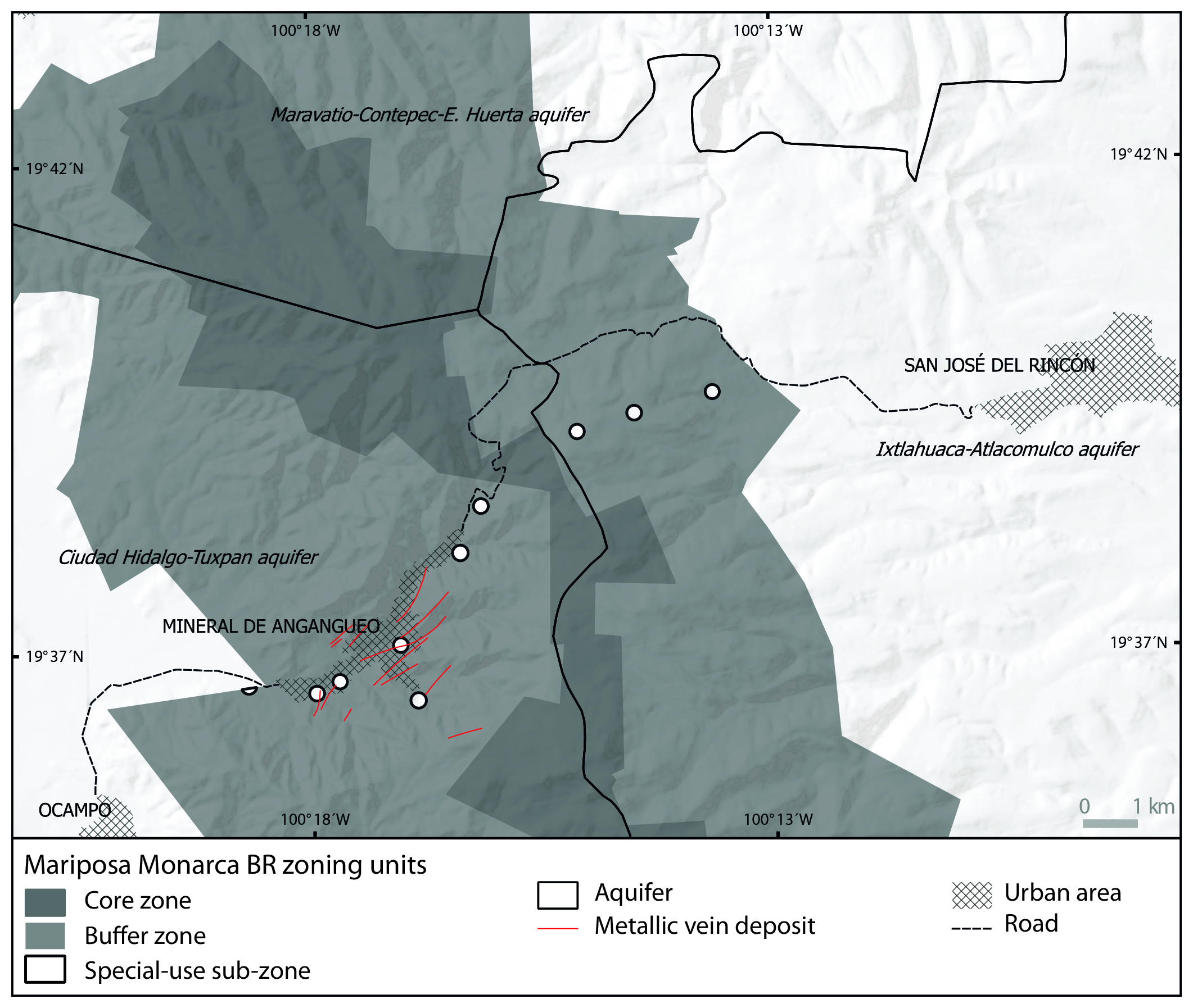
Figure 4 The Mariposa Monarca BR allows mining in 10 small special-use subzones with areas ranging from 2 to 6.7 hectares. The targeted metallic vein deposits exceed the limits of these subzones. Also impact to groundwater systems (aquifers) may exceed these small-scale limits. With additional data from SGM (1995) and CONAGUA (2010).
The Angangueo silver project in the Mariposa Monarca BR highlights an inherent issue in the way SUSZs are implemented for mining operations, namely that they are defined on the land surface, while the mine itself and the area affected by mining operations may extend beyond these limits. Similar situations can be expected in other SUSZs designated for underground mining operations.
In the opposite end of the spectrum, the prevalence of SUSZs of large and extremely large extension makes it clear that these are established according to project requirements rather than environmental factors. Two of the largest active mining operations within FNPAs, the Concheño mine and the Pinos Altos mine complex in the Tutuaca FFPA, are located within some of the largest SUSZs. The Tutuaca FFPA includes a total of four SUSZ polygons: Santa María de Moris (100 ha), Concheño (842 ha), Pinos Altos (7,317 ha), and Promontorio (11,102 ha), accounting for a total of 19,361 ha. Two of these, Concheño and Pinos Altos, host the operations mentioned above while the largest SUSZ, Promontorio, is currently subject to exploration.
Other relevant cases of large SUSZs are the Sierra de la Laguna BR (1,852 ha polygon for the Cardones open-pit gold-mine project which would cover over 469 ha within the protected area; Desarrollos Zapal, 2013) and Valle de los Cirios, with the largest SUSZ of all, a single 26,226 ha polygon defined for the future exploitation of the well-known El Arco copper-gold deposit and the exploration of other nearby mineralized areas.
Impacts Within and Beyond SUSZs
Ultimately, SUSZs should be evaluated in terms of their effectiveness to limit or constrain environmental impacts, thus contributing to conservation. From the definition, resource exploitation within a SUSZ shall be carried out “without deteriorating the ecosystem, modifying the landscape in any substantial manner, or causing irreversible environmental impacts on the natural elements they are part of.” The examples presented below illustrate how SUSZs are not always achieving these goals. Although the impact assessment of individual cases lies beyond the scope of this study, we address in general terms the role of the impact related to SUSZs.
Most relevant in this respect are the open-pit mines and projects within FNPAs, whose impacts will necessarily be irreversible, especially in terms of changes of land cover and modification of landforms, as well as regarding the potential interference with water systems and higher pollution risks (Tutuaca FFPA, Sierra de la Laguna BR, and Valle de los Cirios FFPA). Also, the example of the Mariposa Monarca BR mentioned above illustrates how impacts may not be confined within the SUSZ.
This leads to the question of the goals that SUSZs are actually expected to achieve in terms of conservation. On one side, and closer to the definition, SUSZs can be viewed as “conservation-compatible sites”: areas where mining may be conducted but only in ways that are compatible with conservation (no “irreversible environmental impacts,” ecosystem deterioration, etc.). Indeed, the cases of low-impact and/or small-extent mining cited above conform with this interpretation. The same cannot be said for cases involving large-scale open-pit operations and projects, which fit a rather different way of understanding how SUSZs are used.
In an alternative interpretation, SUSZs can be understood as “contained-impact zones” or “sacrifice zones.” In this interpretation, SUSZs are established to contain both reversible and irreversible impacts, and thus safeguard the rest of the protected area. Under this interpretation, impacts within a SUSZ are not expected to be significantly different from impacts in unprotected areas. This is what occurs in the large-scale mines and projects described above. If this is the case, not much differentiates SUSZs from unprotected land beyond an NPA, rendering both “non-conservation exclaves.” Perhaps some justification for this use of SUSZs may be found in their very name, where the modifier special is used in place of the ubiquitous sustainable when qualifying activities and resource use in all other zoning units.
Between both interpretations, the first appears to be more aligned with conservation goals. However, both are interpretations; therefore, a full understanding of the reasoning behind each zoning scheme can only be adequately assessed after closer inspection of each particular case.
CLOSING REMARKS
Mining exists in many forms throughout the Mexican FNPA system. Mining activities vary widely in terms of mineral type, extraction methods, and operation scale. Indeed, some forms of mining currently carried out within FNPAs may not pose a significant threat to the environment and may be considered compatible with conservation. On the other hand, large-scale operations within FNPAs are clearly in conflict with conservation due to the extensiveness and irreversibility of their impacts, most notably open-pit mines of either metallic (gold-silver, copper) or non-metallic (gypsum, salt) minerals. The impacts of mining within a particular NPA, however, should also be assessed in relation to the conservation values in the proximity to the mining operation. Looking ahead, we suggest conducting case-by-case research in the most notable cases presented here, aiming to identify mining-related impacts in opposition to the specific environmental elements and conservation values of an NPA.
Zoning and management programs are the principal instruments through which mining is allowed within NPAs. Once mining is allowed through favorable zoning schemes and management programs, the applicable regulatory safeguards (chiefly environmental impact assessments) are virtually identical to those applied to unprotected land. In some FNPAs including special-use subzones, highly disruptive mining is currently in operation with impacts that challenge the stated purpose of SUSZs. Furthermore, these zones do not always take into account subsurface processes and impacts, while others seem to be delimited by mining requirements rather than environmental factors. The reassessment of zoning schemes and management programs could greatly contribute to implementing stricter regulations for mining in NPAs.
There is a large set of FNPAs, not considered in this study, that lack a management program and detailed zoning. These cases represent an undefined stance regarding the permissibility of mining in NPAs. Another set of potentially relevant cases not covered here is that of illegal mining within NPAs. This, however, is the result of either negligent oversight or corruption and does not strictly derive from land-use and conservation policies.
Currently, the Mexican environmental policies regarding mining rely heavily on a case-by-case assessment (mainly through environmental impact assessments). However, for NPAs, the categorical prohibition of some types of mining is possible. By its very nature, open-pit extraction and some forms of superficial mine-waste deposits are in apparent conflict with current legislation due to the irreversible nature and magnitude of their impacts. Similarly, operations that directly interact with groundwater may be subjected to greater scrutiny, as the extent of their impacts may extend beyond zone limits.
This work provides a broad view of the current state of the interaction of mining with conservation in Mexico. Further site-based studies are needed to gain a deeper understanding of this issue, , not only to better gauge the environmental impacts of mining or the effectiveness of a particular protected area, but also to understand the social, political, and economic stressors that lie at the heart of this interaction.

