


Servicios Personalizados
Revista
Articulo
 texto en
  Inglés (pdf)
 Artículo en XML
 Referencias del artículo
 Enviar artículo por email
Indicadores
-
 Citado por SciELO
 -
 Accesos
Links relacionados
-
 Similares en
SciELO
Similares en
SciELO
Compartir

 Permalink
Revista mexicana de ciencias agrícolas
versión impresa ISSN 2007-0934
Rev. Mex. Cienc. Agríc vol.7 no.4 Texcoco may./jun. 2016
Articles
Spatial distribution of thrips in avocado in Coatepec Harinas, State of Mexico
1 Ciencias Agropecuarias y Recursos Naturales Facultad de Ciencias Agrícolas- Universidad Autónoma del Estado de México. Toluca, México. A. P. 5020. (irita_3@ hotmail.com).
2 Facultad de Ciencias Agrícolas-Universidad Autónoma del Estado de México. Toluca, México. A. P. 5020. (mrubia@uaemex.mx).
3 Facultad de Geografía-Universidad Autónoma del Estado de México. Toluca, México. A. P. 5020. (xantonion@uaemex.mx; sakua_02@hotmail.com).
The avocado is one of the perennial crops of major economic importance in Mexico, like any other crop, affected by pests and diseases that cause economic and environmental damage. One of the major insect that attacks the crop is Frankliniella occidentalis, these injured avocado leaves and fruit as a result of feeding in the layers of cells of the epidermis, creating areas or pale brown. The lesions may be caused entry points of pathogenic microorganisms. In fruits, the insects come to cause scars or marks, reducing its market value, can cause birth defects in fruit by causing alterations in the newly formed shell fruits, flowers inhibit fertilization and cause them to fall. The objective was to determine the spatial distribution of populations of thrips and mapping the density of three plots four hectares located in the municipality of Coatepec Harinas through the application of geostatistical analysis. The results showed that populations of thrips are grouped into aggregation centers and conform to spherical models mostly. In addition to this, it was determined the area infested by the insect, which will accurately direct control measures in the areas with the largest number of insects through density maps.
Keywords: Frankliniella occidentalis; areas of infestation; avocado; Coatepec Harinas; geostatistical analysis
El aguacate es uno de los cultivos perennes de mayor importancia económica en México, como cualquier otro cultivo, se ve afectado por plagas y enfermedades que causan daños económicos y ecológicos. Uno de los principales insectos que ataca el cultivo es Frankliniella occidentalis, estos lesionan hojas y frutos de aguacate como resultado de su alimentación en las capas de células de la epidermis, creando áreas pálidas o cafés. Las lesiones originadas pueden ser puntos de entrada de microorganismos patógenos. En los frutos, estos insectos llegan a causar cicatrices o marcas, reduciendo su valor en el mercado, pueden producir malformaciones en la fruta al provocar alteraciones en la cáscara de frutos recién formados, inhiben la fecundación de flores y provocan su caída. El objetivo fue determinar la distribución espacial de las poblaciones de trips y la elaboración de mapas de densidad de tres parcelas de cuatro hectáreas ubicadas en el municipio de Coatepec Harinas mediante la aplicación del análisis geoestadístico. Los resultados mostraron que las poblaciones de trips se agrupan en centros de agregación y se ajustan a modelos esféricos en su mayoría. Adicional a ello, se pudo determinar la superficie infestada por el insecto, lo que permitirá dirigir certeramente las medidas de control en las áreas con mayor número de insectos a través de los mapas de densidad.
Palabras clave: Frankliniella occidentalis; aguacate; análisis geoestadístico; áreas de infestación; Coatepec Harinas
Introduction
Traditionally, plant quarantine programs have interpreted the possible impacts that the distribution of an exotic pest could have in a country, based on qualitative and intuitive decisions, making a simplification of the system. In this sense, the use of tools derived from remote sensing and Geographic Information Systems (SIG) can provide efficient elements for risk analysis on the potential of exotic and quarantine pests distribution to countries that assess the import of a given plant product (Dahlsten et al., 1989; LeVeen, 1989). Thus, models of species distribution, understood as cartographic representations of the suitability of an environment to sustain the presence of a species (depending on environmental variables), can become a tool for decision making in potential scenarios invasion.
Several empirical development of insects, particularly phenological models degrees/day, models have been used to predict events development of populations of insects and other poikilothermic organisms (Higley et al., 1986; Milonas et al., 2001). In this regard, studies on the pattern of insect f light is to establish systems alerted and represent a useful tool for conducting phytosanitary actions in a timely manner, facilitating prognosis and prevention (Savopoulou et al., 1996). That is why studies are required to determine the spatial distribution of populations of thrips and thus to implement measures targeted control, this will contribute to reducing losses avocado production.
The avocado (Persea americana Mill.) Is the fourth largest in the world tropical fruit. World production of avocado is estimated at 4.2 million tons. Mexico is the largest producer of avocados in the world, with an average annual production of 1 467 837.35 t in 168 113.64 has obtained a yield of 10.18 t ha-1 (SIAP, 2013). The State of Mexico has 6 671.00 hectares planted (SIAP, 2013). This presents fruit as any crop pests and diseases, for avocado one of the main damage is caused by insects and the largest group is the order belonging to Hemiptera (Moreno et al., 2010). The order of the Thysanoptera, cause damage to prefer feeding on soft tissues such as leaf buds, flowers, young leaves and developing fruits (Castañeda and Johansen, 2011).
Thrips injure avocado leaves and fruits as a result of their diet in the cell layers of the epidermis, creating pale areas or cafes, caused injuries can be entry points for pathogens.
In the fruits of cv. Hass, these insects come to cause scars or marks, reducing its market value. They can cause birth defects in fruit by causing alterations in the newly formed shell fruits, flowers inhibit fertilization and cause them to fall. The reported worldwide species associated with these damages are: Heliothrips haemorrohidalis, Selenothrips rubrocinctus, Scirtothrips persea, S. aceri, Frankliniella spp. and Liothrips perseae. F. occidentalis has presented maximum abundances in periods of vegetative growth, flowering and fruit set, in the period ranging from early January until the onset of rains; in conditions not appropriate these insects staying in weeds (De Villiers and Van den Berg, 1987; Fisher, 1989; Mc Murtry et al., 1991; Coria, 1993; Childers, 1997; Bender, 1998).
Thrips control has been carried out with application of insecticides and weed removal (Coria, 1993; Mendez et al., 1999). Knowledge of the distribution of thrips is indispensable for the development of integrated management programs, due to the importance of this pest, therefore, the objectives were to determine the spatial distribution of adult F. occidentalis in the cultivation of avocado in Coatepec Harinas and map the spatial distribution using spatial statistics, in particular geostatistics it provides a direct measure of spatial dependence, taking into account the two-dimensional nature of the distribution of organisms through its exact location space and display maps (Ramirez and Porcayo, 2010).
Materials and methods
The municipality of Coatepec Harinas is located between parallels 18° 48' and 19° 05' north latitude, meridians 99° 43' and 99° 54' with an altitude of 1 600 and 3 900 meters; the study area consisted of three plots four hectares each. Using the method of quadrants (20 m x 20 m), took 40 of them at random, within each quadrant three trees were selected for sampling, thus having a total of 120 trees ten years old per plot. Biweekly counts of thrips were carried out by placing 12 waste cup trap to catch and count reference thrips adults taking the cardinal points of the tree. Each tree was georeferenced with a model view browser eTrex Vista HC x 2007. The vessels used were plastic yellow color No. 8, 10 cm high, 4.5 cm diameter and base diameter 7.5 cm top edge; this according to the tests made by (Gonzalez et al., 1998). To place the glasses were asked a metal hook at the base, spreading over them shortening for thrips will stick around the outside of the glass, to make observations a magnifying glass 20 x was used, the sampling they started from July 3, 2014 to December 18, 2014.
Geostatistical analysis
The estimation of experimental semivariograms the data collected was performed; the variogram is calculated by the following formula: (Journel and Huijbregts, 1978; and Srivastava Isaak, 1989).
Where: γ* (h) is the experimental semivariogram value for the distance interval h; N (h) is the number of pairs of sample points separated by the distance h interval; z (xi) is the value of the variable of interest in sampling point xi, and z (xi + h) is the value of the variable of interest in the sample point xi + h. Any mathematical function can be used for a model of semivariogram always be positive and definite (Armstrong and Jabin 1981). To carry out the experimental semivariogram for each sampling the Variowin 2.2 program was used. (USA Software for analyzing spatial data in 2D. Primavara. Verlag, New York)
Theoretical models commonly used to fit the experimental semivariogram are the spherical, exponential, Gaussian, the log, the pure nugget effect, the hole effect and monomic according Samper and Carrera (1996), Trematerra and Sciarretta (2002). The model parameters to validate (C0, nugget effect, C, and plateau, range or scope) are modified to obtain adequate statistical cross-validation.
The values of cross-validation are:
To average estimation errors (MEE):
Where: z*(xi) is the estimated value of the variable of interest at the point xi; z (xi) is the measured value of the variable of interest at the point xi and n is the number of sample points used in the interpolation. The MEE should not be significantly different from 0 (t test), in which case indicate that the semivariogram model allows the calculation of unbiased estimators.
b) Mean square error (ECM):
A variogram model is considered adequate if, as a practical rule, the statistical value is close to zero (Hevesi et al., 1992).
c) Dimensionless mean square error (ECMA):
Where: σk is the standard deviation of the expected error in estimating the kriging. The validity of the model is satisfied if ECMA is between the values s 1±2 (2/N) 0.5.
Level of spatial dependence
It was calculated in order to determine the strength of the relationship between sampling data. This value is obtained by dividing the nugget effect between the lower edge, expressed as a percentage. Less than 25% is considered high, between 26 and 75% moderate and greater than 76% is considered low (Cambardella et al., 1994, López et al., 2002).
Mapping: mapping was performed by interpolating values through ordinary kriging that allows unbiased estimate of values associated with points that were not sampled all this based on the provisions of Samper and Carrera (1996). And finally, the surface infested estimates that are represented in the form of maps for each study plot in different sampling dates belonging to the summer- autumn 2014 cycle of F. occidentalis, using the program Surfer 9 (Surface Mapping System, Golden Software Inc. 809, 14th Street. Golden, Colorado 80401-1866. USA).
The calculations were performed infested area based on density maps after validating the semivariograms by kriging.
Results and discussion
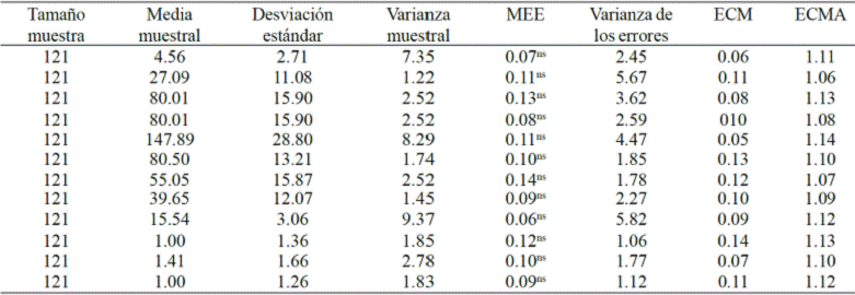
With the obtained data modeling populations of thrips and their representation it was made by population density maps. For semivariograms, most to a gaussian model was adjusted in the first plot, except for sampling one, five, seven, eight and twelve. (Table 1). For all samples, the nugget effect was zero, this value reflects the scale of sampling used was correct and that the sampling error was almost nil. The spatial dependence calculated for all semivariograms was high (Table 1, 2 and 3). The semivariograms were properly validated to be within acceptable ranges (Table 5).
Table 1 Parameters of theoretical models adjusted to the semivariogram of F. occidentalis, by sampling date in Coatepec Harinas, State of Mexico, summer-autumn 2014 (plot 1).
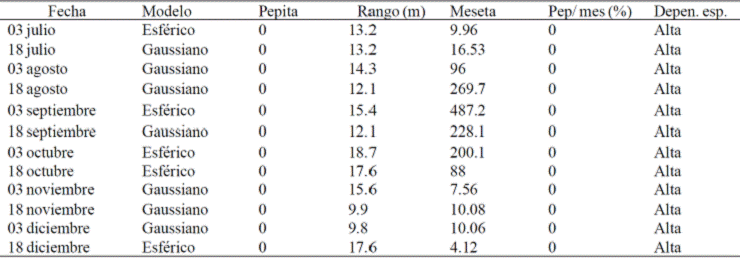
Table 2 Parameters of theoretical models adjusted to the semivariogram of F. occidentalis, by sampling date in Coatepec Harinas, State of Mexico, summer-autumn 2014 (plot 2).
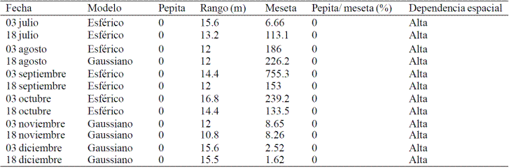
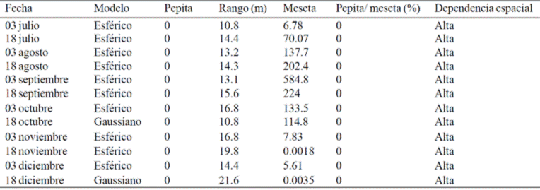
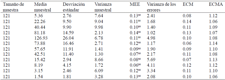
Table 3 Parameters of theoretical models adjusted to the semivariogram of F. occidentalis, by sampling date in Coatepec Harinas, State of Mexico, summer-autumn 2014 (plot 3).
In the phase of structural analysis of the data, the "variogram" function was chosen to characterize the spatial continuity. The variograms were built subsequently adjusted to theoretical models.
Regarding the plot two we can see that the models that were adjusted semivariograms are mostly spherical. The range for the sampling of the plot two ranges between 10.8 and 16.8 m, this data is indicative of the maximum distance that a relationship exists between the data. These data are reflected in the density maps (Figure 2), they can be seen that as many of these insects are in the months of July, August and September, which coincides with the f lowering "crazy" that It presented in these same months, reducing significantly from October to December due to the decrease in temperature (Table 4, Figure 1).
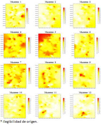

Table 4 Values of statisticians semivariograms obtained cross-sampling validation of F. occidentalis, by quadrants in the municipality of Coatepec Harinas, State of Mexico (plot 1).
MEE= media de los errores de estimación (MEE); ECM= error cuadrático medio (ECM); ECMA= error cuadrático medio adimensional (ECMA).
In the case of the plot three, the tilt range between 10.8 and 21.6, the semivariograms adjusted to spherical model and only two of them to the gaussian model (Table 3), all with high spatial dependence and nugget effect zero. Cross-validation for the three plots and the value of allowable values reflects nugget effect, which corroborates the efficiency of sampling scale and minimal sampling error (Tables 4, 5, 6).
Table 5 Values statisticians semivariograms obtained cross-sampling validation of F. occidentalis, by quadrants in the municipality of Coatepec Harinas, State of Mexico (plot 2).
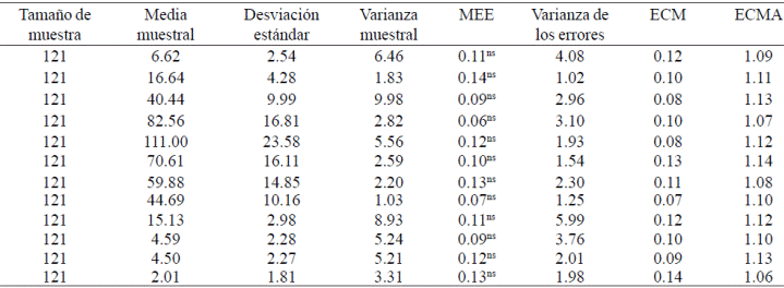
Table 6 Values statisticians semivariograms obtained cross-sampling validation of F. occidentalis, by quadrants in the municipality of Coatepec Harinas, State of Mexico (plot 3).
The statistical parameters of the cross-validation (Tables 4, 5 and 6) allowed validation of experimental semivariograms adjusting to theoretical models, semivariograms of the plot 1 to gaussian model were adjusted almost mostly, but not for the first half of july, september, october and two fortnights the second half of december where adjusted to a spherical model. (Figures 1, 2, 3; Tables 1, 2 and 3) and the plot two was set mostly by the spherical model, the second half of august and the months of november and december a gaussian model model with a structure spatial aggregate (Tables 1, 2 and 3).
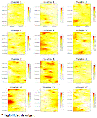
Plot for three most fit a spherical model only two gaussian for the second fortnight of october-december (Tables 1, 2 and 3). In the three plots of sampling aggregate spatial structures F. occidentalis in the study area as seen in Figures 1, 2, 3. This is also consistent with reports showing Solares et al. (2011) who observed a spatial distribution of thrips, type added at different sampling dates. Figure 1 shows the trend distribution of thrips in different sampling dates, for example, for the case of sampling one, two, three, six, ten are located on the right side of the plots to plot four infestation is given to the banks of the plot and in all other cases are located in the central part of the plot and left. The aggregation centers located within the plot two located on the right and central part of the plot in most sampling dates except for 1, 9, 10 and 12 which are located on the left side and sampling 8 which it is located across the board, mainly on the banks of the plot (Figure 2). On the plot three location of thrips on the left side of the plot most density maps (Figure 3) was evident, although in the case of sample 1 and 11 as many thrips was found in the right side of the map and sampling 7 and 8 were placed in the central part of the plot.
Based on the parameters of theoretical models adjusted to semivariograms a large majority of spherical models they are presented, indicating that within the plots there are areas with higher incidence of thrips, which follows in aggregation centers that are located in specific locations (Figures 1, 2, 3) this is largely due to agricultural management which gives the producer. For all models adjusted one nugget zero effect occurred, this value is indicative that the sampling scale used was correct and the sampling error was minimum which means that 100% of the variation of the distribution of F. occidentalis, is explained by the spatial structure established in semivariograms for each sample, this is consistent with those reported by Rossi et al. (1992). As plateau values varied in the three study plots, plot one of 487.2 to 4.12, plot two 755.3 1.62 and plot three of 584.8 to 0.0018 (Table 1, 2 and 3) possibly response types aggregation in the three study plots.
In all models were validated successfully established aggregation maps (Figures 1, 2, 3) of pest incidence allowing viewing. The maps obtained from infested sampling quadrants showed that populations of thrips were located in centers of aggregation surface, indicating that the distribution of the pest, is located at specific points or foci of incidence distributed in the study area. This is consistent with those reported by (Jimenez et al., 2013). For density maps, the red shows the geographical areas in which the largest number of recorded thrips was determined; unlike the white color which is an indication that there are no areas thrips. In plots 1, 2 and 3 (Figures 1, 2, 3) centers targeted aggregation observed.
As shown in Table 7, in the case of the plot one the largest area infested was 92% and 93% in the second half of august and early september; in the case of the plot two the maximum percentage of infestation was reached in the second half of august with 96% of the infested area. In the case of the plot 3, the most infested surface can be observed in the first half of September. While the lower surface with presence of thrips was given in the plot one sampling carried out on 18 december, as low temperatures naturally reduced thrips populations.

Conclusions
With the application of geostatistical techniques it was possible to determine the distribution of insect F. occidentalis in the cultivation of avocado, as these insects are centers scattered aggregation within crop orchards, a situation that was verified in the three study plots in the municipality of Coatepec Harinas, State of Mexico. It is noteworthy that the results show that there was a high spatial dependence between the data and the sampling error was minimal. The highest percentage of infestation was found in the plot two during the month of august with 96% infestation.
Literatura citada
Armstrong, M. and Jabin, R. 1981. Variogram models must be positive definite. Mathematical Geology. 13(5):455-459. [ Links ]
Bender, G. 1998. Avocado thrips in San Diego Country. Subtropical Fruit News. 6(2):14. [ Links ]
Cambardella, C.; Moorman, T.; Novak, J.; Parkin, T.; Karlen, D.; Turco, R. and Konopka, A. 1994. Field scale variability of soil properties in central Iowa soils. Soil. Sci. Soc. Am. J. 58(5):1501-1511. [ Links ]
Castañeda, E. L. y Johanssen, R. M. 2011. Trips asociados al aguacate en el Estado de México. In: Actas del VII Congreso mundial del aguacate. Cairns, Australia. Sociedad internacional de la palta. 1130-1150 pp. [ Links ]
Childers, C. C. 1997. Feeding and oviposition injures to plants. In: Lewis, T. (Ed.). Thrips as crops pests. Cab International. USA. 505-537 pp. [ Links ]
Coria, A.V.M. 1993. Principales plagas del aguacate en Michoacán. Folleto para productores Núm. 19. SAGAR. INIFAP. Mexico. 20 p. [ Links ]
Dahlsten, D.; Garcia, R. and Lorraine, H. 1989. Eradication as a pest management tool: concepts and contexts. In: Dahlsten, D. and Garcia, R. (Eds.). Eradication of exotic pests. Analysis with case histories. Yale University Press. New Haven, Connecticut, USA. 3-15 pp. [ Links ]
De Villers, E. A. and Van Den Berg, M. A. 1987. Avocado insects of South Africa. Afr. Avocado Growers ́Assoc Yrb. 10:75-79. [ Links ]
Fisher, J. B. 1989. Structure and development of surface deformations on avocado fruits. HortSci. 24(5):841-844. [ Links ]
González, H.; Sosa, C. M.; González, M. y Valle de la Paz, A. R. 1998. Selección del color de trampas adhesivas para muestreo de trips en el cultivo del aguacate (Persea americana Mill.). In: Avances de investigación, 1997. Instituto de Fitosanidad, Colegio de Postgraduados. Montecillo, México. 209-210 pp. [ Links ]
Hevesi, J.; Istok, J. and Flint, A. 1992. Precipitation estimation in mountainous terrain using multivariate geostatistics, part I, structural analysis. J. Appl. Meteorol. 31(7):661-676. [ Links ]
Higley, L.; Pedigo, L. and Ostlie, K. 1986. “DEGDAY: a program for calculating degree-days, and assumptions behind the degree- day approach”. Environ. Enthomol. 15(5):999-1016. [ Links ]
Isaaks, E. H. and Srivastava, R. M. 1989. An introduction to applied geostatistics. 1° ed. Oxford Univ. Press. New York, USA. 35-38 pp. [ Links ]
Jiménez, C. R. A.; Ramírez, D. J. F.; Sánchez, P. J. R.; Salgado, S. M. L. y Laguna, A. 2013. Modelización espacial de Frankliniella occidentalis (Thysanoptera: Thripidae) en tomate de cáscara por medio de técnicas geoestadísticas. Rev. Colomb. Entomol. 39(2):183-192. [ Links ]
Journel, A. G. and Huijbregts, Ch. J. 1978. Mining geostatistics. Second ed. Academic Press. Londres, Reino Unido. 600 p. [ Links ]
Le Veen, E. P. 1989. Economic evaluation of eradication programs. In: Dahlsten, D. and Garcia, R. (Eds.). Eradication of exotic pests. Analysis with case histories. Yale University Press. New Haven, Connecticut, USA. 41-56 pp. [ Links ]
López, G. F.; Jurado, E. M.; Atenciano, S.; García, F. A.; Sánchez, M. and García, T. L. 2002. Spatial variability of agricultural soil parameters in southern Spain. Plant Soil. 246(1):97-105. [ Links ]
Mc Murtry, J. A.; Johnson, H. G. and Newberger, S. J. 1991. Imported parasite of greenhouse thrips established on California avocado. California Agriculture. 45(6):31-32. [ Links ]
Méndez, R. A.; González, H. H.; González, R. M. y Valle, P. A. R. 1999. Trips en tres huertos comerciales de aguacate en Michoacán. In: Memorias XXXIV Congreso Nacional de Entomología. Sociedad Mexicana de Entomología A. C. Aguascalientes, México. 368-371 pp. [ Links ]
Milonas, P.; Savopoulou-Soultani, M. and Stavridis, D. 2001. Day-degree models for predicting the generation time and fight activity of local populations of Lobesia botrana (Den. y Schiff.) (Lep., Tortricidae) in Greece. J. Appl. Entomol. 125(9-10):515-518. [ Links ]
Moreno, S.; Rocha, A.; Alvarado, M. A.; Salgado, M. G. y Pinson, E. P. 2010. Aguacate variedades, cultivo y producción en Nuevo León. Primera ed. Universidad Autónoma de Nuevo León. México. México. 148 p. [ Links ]
Ramírez, D. J. F. y Porcayo, E. 2010. Estudio comparativo de la distribución espacial del muérdago enano (Arceuthobium sp.) en la ladera norte del parque nacional nevado de Toluca, México, utilizando el método de SADIE. Madera y Bosques 34(1):93-111. [ Links ]
Rossi, R.; Mulla, J.; Journel, G. and Franz, H. 1992. Geostatical tools for modeling and interpreting ecological spatial dependence. Ecol.l Monographs. 62(2):277-314. [ Links ]
Samper, F. J. y Carrera, J. 1996. Geoestadística: aplicaciones a la hidrología subterránea. Segunda (Ed.). Centro Internacional de Métodos en Ingeniería. Barcelona, España. 484 p. [ Links ]
Savopoulou S. M.; Milonas, P. and Skoulakis, G. 1996. Development and life-fertility tables for Lobesia botrana (Den. y Schiff.) (Lepidotera: Tortricidae) larvae. J. Econ. Entomol. 92(1):551- 556. [ Links ]
SIAP. 2013. Anuario estadístico de la producción agrícola. http://www.siap.gob.mx (consultado octubre, 2014). [ Links ]
Solares, V.; Ramírez, J. F. y Sánchez, R. 2011. Distribución espacial de trips (Insecta: Thysanoptera) en el cultivo de aguacate (Persea americana Mill.) Boletín del Museo de Entomología de la Universidad del Valle. 12(2):1-12. [ Links ]
Trematerra, P. and Sciarretta, A. 2002. Spatial distribution of some beetles infesting a feed mill with spatio-temporal dynamics of Oryzaephilus surinamensis, Tribolium castaneum and Tribolium confusum. J. Stored Prod. Res. 40(4): 363-377. [ Links ]
Received: January 2016; Accepted: May 2016
 Este es un artículo publicado en acceso abierto bajo una licencia Creative Commons
